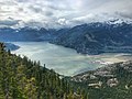
The Sea-to-Sky Corridor, often referred to as the Corridor or the Sea to Sky Country, is a region in British Columbia spreading from Horseshoe Bay through...
9 KB (495 words) - 00:08, 21 October 2022

Parapet Peak (Garibaldi Provincial Park) (category Sea-to-Sky Corridor)
into the headwaters of the Pitt River, whereas the northern slope drains to Cheakamus Lake via Isosceles Creek. Topographic relief is significant as the...
5 KB (399 words) - 19:12, 29 June 2023
Horseshoe Bay to Pemberton Sea-to-Sky Corridor, the region around the Sea-to-Sky Highway which includes Whistler Sea to Sky University, a university in Squamish...
735 bytes (141 words) - 17:33, 15 September 2020
The Sea to Sky Trail is a 180 km (110 mi) multi-use recreational trail in the Sea-to-Sky Corridor of British Columbia, Canada. The trail begins in the...
7 KB (598 words) - 02:47, 30 April 2024

Wedgemount Lake (category Sea-to-Sky Corridor)
Volcanic Belt Garibaldi Provincial Park Wikimedia Commons has media related to Wedgemount Lake. BC Parks: Garibaldi Provincial Park LiveTrails: Wedgemount...
2 KB (90 words) - 11:35, 5 November 2023

Cheakamus Lake (category Sea-to-Sky Corridor)
Cheakamus Lake is a lake in Garibaldi Provincial Park on the southeastern outskirts of the resort municipality of Whistler, British Columbia. It has an...
2 KB (105 words) - 08:47, 5 November 2023

Quest University (redirect from Sea to Sky University)
originally created as the Sea to Sky University in May 2002, when the Legislative Assembly of British Columbia passed the Sea to Sky University Act. One of...
27 KB (2,714 words) - 20:15, 31 January 2024
Watts Point (category Sea-to-Sky Corridor)
Watts Point is a point in southwestern British Columbia, Canada, located on the eastern side of Howe Sound northwest of Britannia Beach. Watts Point volcanic...
429 bytes (52 words) - 01:22, 7 February 2024
Stawamus Lake (category Sea-to-Sky Corridor)
Stawamus is a lake in the North Shore Mountains of British Columbia, Canada, which forms the head of the Stawamus River. List of lakes of British Columbia...
3 KB (39 words) - 11:05, 5 November 2023
Squamish Airport (category Sea-to-Sky Corridor)
Olympics. Canada Flight Supplement. Effective 0901Z 16 July 2020 to 0901Z 10 September 2020. Wikimedia Commons has media related to Squamish Airfield. v t e...
2 KB (124 words) - 23:16, 21 January 2022

In-SHUCK-ch Mountain (category Sea-to-Sky Corridor)
mountain is pronounced In-SHUCK-ch, meaning "split like a crutch", which refers to the split gap of the summit area. The people of the In-SHUCK-ch Nation took...
5 KB (480 words) - 00:46, 7 March 2024
Cheekye River (category Sea-to-Sky Corridor)
This article related to a river in British Columbia, Canada is a stub. You can help Wikipedia by expanding it....
633 bytes (55 words) - 17:05, 10 April 2024
Woodfibre, British Columbia (category Sea-to-Sky Corridor)
name until 1959, when the company name was changed to Rayonier Canada, Ltd. Rayonier continued to operate the mill until 1980, when the company exited...
5 KB (572 words) - 19:53, 13 February 2024

Evans Lake (British Columbia) (category Sea-to-Sky Corridor)
Rivers in British Columbia, Canada. The 604-acre (2.44 km2) site has been home to youth camps since 1959. For decades Evans Lake was used primarily by the Junior...
2 KB (131 words) - 23:34, 6 February 2024
Mamquam River (category Sea-to-Sky Corridor)
9 km to its confluence with its second named tributary, Martin Creek. At the mouth of Martin Creek, the river turns southwest for about 5.4 km to the mouth...
4 KB (321 words) - 04:04, 2 November 2023

Mount Neal (category Sea-to-Sky Corridor)
Precipitation runoff and glacial meltwater from this mountain's slopes drains to the Lillooet River via Ure, Kakila, and Chaos creeks. Mount Neal is more notable...
5 KB (440 words) - 01:22, 7 March 2024

Outlier Peak (category Sea-to-Sky Corridor)
drains into headwaters of the Cheakamus River, whereas the other slopes drain to the Lillooet River via Billygoat Creek. Outlier Peak is more notable for its...
5 KB (384 words) - 04:09, 8 March 2024

Sloquet Hot Springs (category Sea-to-Sky Corridor)
the time before European and Canadia settlers arrive. The Xa'xtsa continue to use the thermal springs for their traditional ceremonies. The hot spring emerges...
7 KB (346 words) - 01:31, 24 December 2023

Mount Cook (British Columbia) (category Sea-to-Sky Corridor)
northeast of Whistler, and its nearest higher peak is Mount Weart, 1.2 km (1 mi) to the southeast. The Armchair Glacier is set between Cook and Weart, and the...
4 KB (344 words) - 08:52, 8 March 2024

Alexander Falls (category Sea-to-Sky Corridor)
area of the Sea to Sky Country of southwestern British Columbia, Canada. The falls are located just below a bridge on the access road to Callaghan Lake...
2 KB (139 words) - 23:05, 6 February 2024

Ipsoot Mountain (category Sea-to-Sky Corridor)
mountain was named by the first ascent party, and "ipsoot" means "hidden", or "to hide" in Chinook Jargon, as this peak is indeed hidden from view in adjacent...
5 KB (414 words) - 07:39, 9 March 2024

Carcajou Peak (category Sea-to-Sky Corridor)
drains into headwaters of the Cheakamus River, whereas the north slope drains to the Lillooet River via Billygoat Creek. Carcajou Peak is more notable for...
5 KB (400 words) - 04:17, 8 March 2024

Guard Mountain (category Sea-to-Sky Corridor)
where they are forced upward by the range (Orographic lift), causing them to drop their moisture in the form of rain or snowfall. As a result, the Coast...
5 KB (369 words) - 23:14, 28 June 2023
Brandywine Creek (British Columbia) (category Sea-to-Sky Corridor)
This article related to a river in the Coast of British Columbia, Canada is a stub. You can help Wikipedia by expanding it....
2 KB (201 words) - 04:09, 2 November 2023
Jim Haberl Hut (category Sea-to-Sky Corridor)
Canada Jim Haberl Hut at bivouac.com Air Reserve partnership announcement to build the hut Jim Haberl accident article at mountainzone.com Westwide Avalanche...
2 KB (244 words) - 19:42, 4 July 2023

Rainbow Mountain (British Columbia) (category Sea-to-Sky Corridor)
Pacific Ranges of British Columbia, Canada. Located in the middle of the Sea to Sky Country, the mountain is just 9 km (5.6 mi) northwest of the resort town...
3 KB (225 words) - 02:40, 4 March 2024

Slhanay (category Sea-to-Sky Corridor)
successfully applied, probably due in large part to local tradition and an inability to get such an alternative name to "stick". This was remedied in 2009 when...
3 KB (234 words) - 01:13, 7 February 2024

Ossa Mountain (category Sea-to-Sky Corridor)
upon which the Aloadaes are said to have attempted to pile Mount Pelion on top of Mount Ossa in their attempt to scale Olympus, home of the Greek gods...
5 KB (401 words) - 14:40, 29 October 2023

Whirlwind Peak (category Sea-to-Sky Corridor)
Overlord Mountain, and the nearest higher neighbor is Refuse Pinnacle, 0.94 km to the east-northeast. Precipitation runoff from the peak drains into tributaries...
5 KB (407 words) - 02:05, 7 March 2024

Area code 604 (category Sea-to-Sky Corridor)
area comprises the Lower Mainland, Sunshine Coast, Howe Sound / Sea to Sky Corridor, Fraser Valley and the lower Fraser Canyon regions. The major city...
12 KB (1,672 words) - 18:04, 9 July 2023