
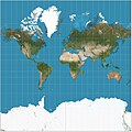
The Universal Transverse Mercator (UTM) is a map projection system for assigning coordinates to locations on the surface of the Earth. Like the traditional...
18 KB (2,852 words) - 18:12, 30 March 2025

by a particular map projection. Each projected coordinate system, such as "Universal Transverse Mercator WGS 84 Zone 26N," is defined by a choice of map...
21 KB (2,805 words) - 11:47, 25 December 2024

mathematics of coordinate systems and analytic geometry to geographic space. A particular SRS specification (for example, "Universal Transverse Mercator WGS 84...
15 KB (1,570 words) - 12:19, 7 May 2025
modified transverse Mercator (MTM) coordinate system is a metric grid-based method of specifying locations, similar to the Universal Transverse Mercator coordinate...
471 bytes (50 words) - 13:52, 3 October 2019
the actual year of release. Public Land Survey System Universal Transverse Mercator coordinate system Doyle, David R. (January 2004). "NGS Geodetic Toolkit...
7 KB (965 words) - 15:06, 26 February 2024
national grid systems around the world use the transverse Mercator, as does the Universal Transverse Mercator coordinate system. An oblique Mercator projection...
49 KB (6,860 words) - 13:34, 7 May 2025

mapping systems around the world, including the Universal Transverse Mercator. When paired with a suitable geodetic datum, the transverse Mercator delivers...
40 KB (4,647 words) - 19:20, 21 April 2025
derived from the Universal Transverse Mercator (UTM) grid system and the Universal Polar Stereographic (UPS) grid system, but uses a different labeling convention...
15 KB (2,140 words) - 08:57, 12 November 2024
Transverse Mercator projection has many implementations. Louis Krüger in 1912 developed one of his two implementations that expressed as a power series...
25 KB (4,902 words) - 15:08, 22 November 2024

Irish Transverse Mercator (ITM) is the geographic coordinate system for Ireland. It was implemented jointly by the Ordnance Survey Ireland (OSi) and the...
7 KB (698 words) - 03:33, 9 March 2025
Ordnance Survey National Grid (redirect from British national grid reference system)
The Irish Transverse Mercator (ITM) coordinate reference system was adopted in 2001 and is now the preferred coordinate reference system across Ireland...
19 KB (2,175 words) - 10:16, 2 May 2025
Natural Area Code (redirect from Universal Address)
System Universal Transverse Mercator coordinate system Quadtree Geohash https://www.researchgate.net/publication/389945471_Natural_Area_Coding_System...
4 KB (451 words) - 11:01, 19 March 2025

The universal polar stereographic (UPS) coordinate system is used in conjunction with the universal transverse Mercator (UTM) coordinate system to locate...
4 KB (499 words) - 18:09, 11 June 2024

Yisra'el Ha-Ḥadasha) is the new geographic coordinate system for Israel. The name is derived from the transverse Mercator projection it uses and the fact that...
5 KB (447 words) - 08:31, 24 April 2025
a zipped KML file Latitude Longitude Universal Transverse Mercator coordinate system (UTM) World Geodetic System GPS and Positioning Services FAQ, Q1...
6 KB (615 words) - 22:40, 28 February 2025
far-off figures using such a projection. The Universal Transverse Mercator coordinate system and the Lambert system in France are projections that support the...
11 KB (1,211 words) - 00:36, 1 September 2024
medications Map Grid of Australia, a mapping system based on the Universal Transverse Mercator coordinate system Mga (river) in Leningrad Oblast, Russia Mga...
3 KB (379 words) - 00:19, 27 February 2025
Universal testing machine, a machine used to test the tensile and compressive stresses in materials Universal Transverse Mercator coordinate system,...
2 KB (280 words) - 01:14, 25 April 2025
system Universal polar stereographic coordinate system Universal Transverse Mercator coordinate system Geographical distance Roger Foster; Dan Mullaney. "Basic...
34 KB (5,207 words) - 08:18, 10 August 2024
a developable surface. 360 video projection List of national coordinate reference systems Snake Projection Snyder, John P. (1993). Flattening the Earth:...
32 KB (772 words) - 04:49, 5 May 2025
{B^{2}+E^{2}}}} World files describing a map on the Universal Transverse Mercator coordinate system (UTM) use these conventions: D and B are usually 0...
9 KB (1,248 words) - 14:06, 8 March 2025

Geohash (category Geographic coordinate systems)
aka. "plus codes", Google Maps) QRA locator (1959) Universal Transverse Mercator coordinate system verbal-id what3words (2013, proprietary) WhatFreeWords...
26 KB (2,703 words) - 05:23, 21 December 2024
text encoding of geographic coordinates Universal Transverse Mercator coordinate system – Map projection system "Incorporation". Companies House. 5 March...
28 KB (2,639 words) - 08:33, 12 May 2025
National Grid. At the same time as GDA94 was defined, a Universal Transverse Mercator coordinate system called the Map Grid of Australia 1994 (MGA94) was also...
4 KB (396 words) - 17:09, 19 January 2025
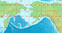
Bering Sea with latitude and longitude zones of the Universal Transverse Mercator coordinate system Bering Sea Coordinates 58°0′N 178°0′W / 58.000°N...
24 KB (2,344 words) - 11:20, 11 February 2025

United States Geological Survey (redirect from National Water Information System)
Land Survey System, and cartesian coordinates in both the State Plane Coordinate System and the Universal Transverse Mercator coordinate system. Other specialty...
35 KB (3,595 words) - 08:13, 29 April 2025
the following parameters for the projection: Jordan Transverse Mercator Geographic Coordinate System: GCS_International_1924 Datum: D:International_1924...
2 KB (275 words) - 00:38, 5 November 2024
Mapcode (category Geographic coordinate systems)
geographic coordinates Universal Transverse Mercator coordinate system – Map projection system What3words – Proprietary geocoding system "Should Mapcodes Replace...
7 KB (961 words) - 18:21, 22 January 2025
Northern Ireland jointly implemented a new coordinate system for Ireland called Irish Transverse Mercator, or ITM, a location-specific optimisation of...
7 KB (754 words) - 22:01, 25 March 2025
Address geocoding (category Geographic information systems)
Reference System is the geocoordinate standard used by NATO militaries for locating points on Earth. Universal Transverse Mercator coordinate system is a map...
29 KB (3,771 words) - 03:10, 11 March 2025