
Madagascar is a large island in the Indian Ocean off the eastern coast of Southern Africa, east of Mozambique. It has a total area of 587,040 square kilometres...
30 KB (2,866 words) - 20:13, 9 April 2024

Antananarivo (redirect from Capital of Madagascar)
(pronounced [tana]), is the capital and largest city of Madagascar. The administrative area of the city, known as Antananarivo-Renivohitra ("Antananarivo-Mother...
87 KB (9,022 words) - 19:34, 3 June 2024
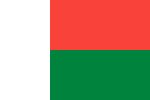
Madagascar, officially the Republic of Madagascar, is an island country comprising the island of Madagascar and numerous smaller peripheral islands. Lying...
224 KB (21,017 words) - 20:55, 6 June 2024
Madagascar may also refer to: Geography of Madagascar Madagascar Plate Madagascar (1994 film), a Cuban film by Fernando Pérez Madagascar (franchise), a film franchise...
2 KB (265 words) - 23:38, 17 March 2024
of Madagascar ISO country codes: MG, MDG, 450 ISO region codes: See ISO 3166-2:MG Internet country code top-level domain: .mg Geography of Madagascar...
15 KB (863 words) - 13:15, 30 October 2023

Tsingy de Bemaraha Strict Nature Reserve (redirect from Tsingy (Madagascar))
western coast of Madagascar in Melaky Region. The area was listed as a UNESCO World Heritage Site in 1990 due to the unique geography, preserved mangrove...
5 KB (283 words) - 07:17, 18 April 2024

Tsiribihina in the Menabe region of western Madagascar. Its striking landscape draws travelers from around the world, making it one of the most visited locations...
7 KB (699 words) - 02:11, 18 March 2024

Madagascar elects on the national level a head of state – the president – and a legislature. The president is elected for a five-year term by the people...
3 KB (249 words) - 13:10, 9 April 2024
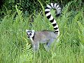
composition of Madagascar's wildlife reflects the fact that the island has been isolated for about 88 million years. The prehistoric breakup of the supercontinent...
31 KB (2,938 words) - 01:52, 14 May 2024
Time in Madagascar is given by a single time zone, officially denoted as East Africa Time (EAT; UTC+03:00). Madagascar does not observe daylight saving...
2 KB (181 words) - 21:00, 4 June 2024

and habitat loss, and soil loss. It has been noticed that Madagascar has lost 80 or 90% of its "original" or "pre-human" forest cover, but this claim...
32 KB (3,455 words) - 14:27, 5 April 2024
The East Madagascar Current is an oceanic flow feature near Madagascar. It flows southward from 20°S on the east side of Madagascar to the southern limit...
2 KB (244 words) - 07:19, 11 April 2022

This is a list of renamed places in Madagascar. For most of these places the French name is still commonly used, including in administrative papers & nameplates...
2 KB (95 words) - 04:05, 23 February 2023

Tsingy de Bemaraha National Park (category Geography of Madagascar)
National Park is a national park located in northwest Madagascar. It is mainly within the boundaries of Antsalova District, with a small part in the northeast...
5 KB (375 words) - 07:16, 18 April 2024
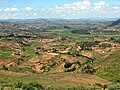
are a mountainous biogeographical region in central Madagascar. They include the contiguous part of the island's interior above 800 m (2,600 ft) elevation...
4 KB (490 words) - 03:22, 20 November 2023

Southern Africa (redirect from Geography of Southern Africa)
Lesotho, Madagascar, Malawi, Mauritius, Mozambique, Namibia, South Africa, Zambia, and Zimbabwe. In cultural geography, the island country of Madagascar is...
37 KB (3,943 words) - 14:01, 10 May 2024

Mauritia (microcontinent) (category Geography of Madagascar)
was a Precambrian microcontinent that was situated between India and Madagascar until their separation about 70 million years ago. Being initially attached...
6 KB (529 words) - 13:00, 17 May 2024

of Imerina are hills of historical significance to the Merina people of Madagascar. Located throughout Imerina, the central area of the highlands of Madagascar...
14 KB (1,320 words) - 22:21, 11 March 2024

of Madagascar. It is an overseas region of France. The total area of the island is 2,512 km2, of which 10 km2 is water. The island has a coastline of...
3 KB (220 words) - 03:46, 20 April 2024
coordinates) Transport in Madagascar List of roads in Madagascar Rail transport in Madagascar Geography of Madagascar List of rivers of Madagascar Wikimedia Commons...
12 KB (577 words) - 18:46, 13 February 2024

provided as an overview of and topical guide to geography: Geography – study of Earth and its people. an academic discipline – a body of knowledge given to...
86 KB (7,707 words) - 12:34, 6 June 2024
Fenambosy Chevron (category Geography of Madagascar)
Fenambosy Chevron is one of four chevron-shaped land features on the southwest coast of Madagascar, near the tip of Madagascar, 180 meters (590 ft) high...
2 KB (276 words) - 07:42, 12 April 2024

Mayotte is an island of volcanic origin in the northernmost Mozambique Channel, about one-half of the way from northern Madagascar to northern Mozambique...
3 KB (237 words) - 07:41, 15 April 2024
a list of major cities in Madagascar with population (1993 census and 2018 census), region, and former province. These are listed in order of their 2018...
15 KB (343 words) - 14:15, 5 April 2024

Canal des Pangalanes (category Geography of Madagascar)
grey-colored slime. Madagascar portal Geography portal Transport portal Lists of canals Le Canal des Pangales circulable Lonely Planet Madagascar, Emilie Filou...
6 KB (611 words) - 14:33, 13 February 2024
Andasibe-Mantadia National Park (category Geography of Madagascar)
about 150 km east of Antananarivo, consisting principally of primary growth forest in Alaotra-Mangoro Region in eastern Madagascar. The park's elevation...
7 KB (691 words) - 07:16, 18 April 2024

of-Nigeria-41_fig1_341527659 "Monsoon - meteorology". Encyclopaedia Britannica. Umar, Abubakar. "GEOGRAPHY OF NIGERIA". "Climate |...
56 KB (3,750 words) - 11:22, 26 May 2024
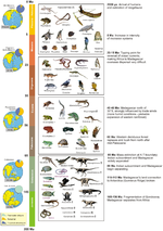
The fauna of Madagascar is a part of the wildlife of Madagascar. Madagascar has been an isolated island for about 70 million years, breaking away from...
35 KB (3,529 words) - 14:52, 22 May 2024

Ismailia 27°00′N 30°00′E / 27.000°N 30.000°E / 27.000; 30.000 The geography of Egypt relates to two regions: North Africa and West Asia. Egypt has coastlines...
20 KB (2,827 words) - 09:16, 4 June 2024

Glorioso Islands (redirect from Geography of the Glorioso Islands)
by Comoros, Madagascar and formerly by Seychelles. They are geographically part of the Comoro Islands between the French overseas region of Mayotte and...
8 KB (757 words) - 17:22, 26 April 2024