
A digital elevation model (DEM) or digital surface model (DSM) is a 3D computer graphics representation of elevation data to represent terrain or overlaying...
31 KB (3,352 words) - 04:25, 21 February 2025

Advanced Spaceborne Thermal Emission and Reflection Radiometer (redirect from ASTER Global Digital Elevation Model)
after 1 April 2008 has been marked as unusable. The ASTER Global Digital Elevation Model (GDEM) is available at no charge to users worldwide via electronic...
13 KB (1,082 words) - 21:33, 9 February 2025

The elevation of a geographic location is its height above or below a fixed reference point, most commonly a reference geoid, a mathematical model of the...
6 KB (561 words) - 17:58, 4 May 2025
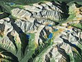
The Reference Elevation Model of Antarctica (REMA) is a digital elevation model (DEM) that covers almost the entire continent of Antarctica at a resolution...
4 KB (516 words) - 05:26, 31 March 2025
DTED (redirect from Digital Terrain Elevation Data)
Digital Terrain Elevation Data) is a standard of digital datasets which consists of a matrix of terrain elevation values, i.e., a Digital Elevation Model...
3 KB (280 words) - 00:48, 2 October 2024

Topography (section Digital elevation modeling)
Satellite RADAR mapping is one of the major techniques of generating Digital Elevation Models (see below). Similar techniques are applied in bathymetric surveys...
17 KB (1,988 words) - 19:00, 7 May 2025

bathymetric models in shallow water. The main constituents of airborne lidar include digital elevation models (DEM) and digital surface models (DSM). The...
128 KB (14,548 words) - 02:56, 24 April 2025
USGS DEM (category Digital elevation models)
the United States Geological Survey for storing a raster-based digital elevation model. It is an open standard, and is used throughout the world. It has...
7 KB (577 words) - 05:26, 10 December 2023

often called a digital elevation model (DEM), which can be further used to produce digital surface models (DSM) or digital terrain models (DTM). An advantage...
5 KB (620 words) - 22:45, 20 March 2024

Geographic information system (section Data modeling)
The digital elevation model, consisting of surface elevations recorded on a 30-meter horizontal grid, shows high elevations as white and low elevation as...
101 KB (13,199 words) - 22:48, 8 April 2025

widespread use. Computerized methods for watershed delineation use digital elevation models (DEMs), datasets that represent the height of the Earth's land...
30 KB (3,165 words) - 18:17, 19 April 2025

relief model, sometimes also denoted as global topography model or composite model, combines digital elevation model (DEM) data over land with digital bathymetry...
8 KB (1,001 words) - 03:31, 26 April 2025

the area between so scale may not be uniform across the image. A digital elevation model (DEM) is required to create an accurate orthophoto as distortions...
6 KB (607 words) - 22:04, 3 May 2025

mainly as Discrete Global Grid in secondary elevation modeling. Each pixel stores values, such as surface elevation data, for display in 3D computer graphics...
6 KB (624 words) - 12:16, 4 April 2024

Shuttle Radar Topography Mission (category Digital elevation models)
that obtained digital elevation models on a near-global scale from 56°S to 60°N,: 4820 to generate the most complete high-resolution digital topographic...
21 KB (2,113 words) - 11:06, 26 April 2025
Landforms by Object-Based Image Analysis and Spectral Parameters of Digital Elevation Model". IEEE Transactions on Geoscience and Remote Sensing: 1–17. doi:10...
4 KB (405 words) - 20:10, 13 July 2023
Raster Product Format) USGS DEM – The USGS' Digital Elevation Model GTOPO30 – Large complete Earth elevation model at 30 arc seconds, delivered in the USGS...
23 KB (2,996 words) - 09:53, 2 April 2025
Raised-relief map (redirect from Topographical relief model)
a raised-relief map using a 3D printer, Digital Elevation Models (DEM) are rendered into a 3D computer model, which can then be sent to a 3D printer....
13 KB (1,663 words) - 21:06, 4 April 2025
particularly important in geostatistics, where it is used to create a digital elevation model from a set of points on the Earth's surface (for example, spot...
6 KB (758 words) - 20:41, 17 February 2025

Terrain (section Digital terrain model)
specific landforms. A digital elevation model (DEM) or digital surface model (DSM) is a 3D computer graphics representation of elevation data to represent...
14 KB (1,586 words) - 03:40, 26 April 2025
3D terrain model is adopted as the carrier for the demands in many correlative fields. Based on the regular grid DEM (Digital Elevation Model) in DRGS,...
2 KB (276 words) - 08:09, 27 April 2025

Andreas (2004). "Combining satellite multispectral image data and a digital elevation model for mapping debris-covered glaciers". Remote Sensing of Environment...
23 KB (2,946 words) - 02:11, 30 November 2024
800 km north of Giza. In 2003, a new calculation based on a global digital elevation model obtained from satellite measurements, ETOPO2, whose data points...
8 KB (873 words) - 04:11, 2 May 2025
GTOPO30 (category Digital elevation models)
GTOPO30 is a digital elevation model for the world, developed by United States Geological Survey (USGS). It has a 30-arc second resolution (approximately...
6 KB (128 words) - 21:28, 14 September 2023
spatial data. It is particularly suited to handling Digital Elevation Models (DEMs) and other surface models. It is written in Java and runs on Windows, Mac...
2 KB (202 words) - 15:47, 9 January 2024

conducted a topographical analysis of Yonaguni Island using a digital elevation model and geological field investigations of the strata, rocks, and microtopography...
12 KB (1,269 words) - 21:59, 11 January 2025
software package allows the creation of orthophoto mosaics and digital elevation model (DEM). Some services the company offers include: Orthophotos are...
15 KB (1,739 words) - 16:06, 8 January 2024
Ramer–Douglas–Peucker algorithm (category Digital signal processing)
through the application of an iterative method. The running time for digital elevation model generalization using the three-dimensional variant of the algorithm...
12 KB (1,189 words) - 03:53, 14 March 2025

valleys, etc.) are called oronyms. Landforms may be extracted from a digital elevation model (DEM) using some automated techniques where the data has been gathered...
9 KB (1,046 words) - 21:40, 12 May 2025

vector source for topography data, often rasterized as a (raster) digital elevation model. Display list Spatial anti-aliasing Michael F. Worboys (30 October...
8 KB (838 words) - 16:10, 28 April 2025