
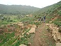
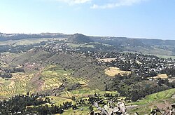
Addi Azmera is a tabia or municipality in the Dogu'a Tembien district of the Tigray Region of Ethiopia. The name refers to good spring rains (“azmera”)...
26 KB (2,343 words) - 00:24, 25 May 2025
Addi Azmera Hurura River, in tabia Addi Azmera May Ayni River, in tabia Addi Azmera Afedena River, in tabia Addi Azmera Shimbula River, in tabia Addi...
81 KB (10,139 words) - 10:59, 8 June 2025

Addi Walka is a tabia or municipality in the Dogu'a Tembien district of the Tigray Region of Ethiopia. The tabia centre is in Kelkele village, located...
14 KB (1,052 words) - 18:41, 12 November 2023
Ayninbirkekin (redirect from Addi Werat)
River, in tabia Addi Azmera Afedena River, in tabia Addi Azmera, which takes its source in Ra'isot May Ayni River, in tabia Addi Azmera, which takes also...
30 KB (2,747 words) - 08:14, 24 May 2025

Emni Ankelalu (redirect from Addi Ateroman)
river baseflow in the downstream areas, which largely belong to tabias Addi Azmera and Debre Nazret. The lower villages of Emni Ankelalu will see their...
19 KB (1,595 words) - 19:07, 27 May 2025

Simret (redirect from Addi Shinqur)
Addi across the Mennewe valley in the northeast of the tabia. There are regular bus services to these towns. Further, a rural access road links Addi Shinqur...
21 KB (1,923 words) - 22:46, 24 May 2025
Walta (Dogu'a Tembien) (redirect from Addi Ferti)
the local people. The main springs in the tabia are: Kalena in Addi Ferti May Shafa in Addi Ferti May Ayni in Da’erere May Tselot near Giba River In this...
24 KB (2,163 words) - 16:46, 25 May 2025
Selam (Dogu'a Tembien) (redirect from Addi Werho)
Tembien district of the Tigray Region of Ethiopia. The tabia centre is in Addi Werho village, located approximately 3 km to the northeast of the woreda...
26 KB (2,159 words) - 20:07, 3 June 2025

Mahbere Sillasie (redirect from Addi Geza'iti)
for the local people. The main springs in the tabia are: Addi Geza'iti May Zeleqo in Guderbo Addi Anefti in May Mereb In this area with rains that last only...
21 KB (1,846 words) - 19:35, 26 May 2025
Seret (Dogu'a Tembien) (redirect from Addi Mishahan)
main other populated places are: May Weyni Addi Mishahan Mezegat Duwele Mashih May Ch’iwara Haddush Addi (shared with Mika'el Abiy) The latter two villages...
20 KB (1,825 words) - 15:34, 25 May 2025

Addilal (redirect from Addi Gedged)
three olive trees ("Mi'iraf Janhoy" at 1940 metres above sea level in Addi Azmera), across Addilal, and further up towards Ekli Imba the peak of the Medayq...
20 KB (1,765 words) - 21:58, 26 May 2025

Haddinnet (redirect from Addi Hamushenay)
Tembien district of the Tigray Region of Ethiopia. The tabia centre is in Addi Idaga village, located approximately 6.5 km to the northeast of the woreda...
23 KB (1,732 words) - 22:41, 23 May 2025

Amanit (redirect from Addi Lihtsi)
Dogu'a Tembien district of the Tigray Region of Ethiopia. The tabia centre is Addi Qeshofo village, located approximately 15 km to the southeast of the woreda...
23 KB (2,051 words) - 08:10, 24 May 2025

Debre Nazret (redirect from Addi Reget)
and at the west by Addi Keshofo River. The highest peak is Imba Bete Gyergis (2390 m a.s.l.) and the lowest place the junction of Addi Keshofo and Giba...
24 KB (2,113 words) - 00:18, 24 May 2025

Menachek (redirect from Addi Bayro)
Millash district of the Tigray Region of Ethiopia. The tabia centre is in Addi Bayro village (also called "Debre Birhan"). Until January 2020 it belonged...
16 KB (1,300 words) - 22:34, 15 October 2023

• location Mesenqoy in Addi Azmera municipality • elevation 2,312 m (7,585 ft) Mouth Hurura River • location Tukhul in Addi Azmera municipality • coordinates...
8 KB (711 words) - 23:33, 22 November 2024

Lim'at (redirect from Addi Gerahti)
more primary schools across the tabia. The main other populated places are: Addi Gerahti Hahawti Agerbi’a Adawro Ksad Adawro The tabia holds several exclosures...
21 KB (1,740 words) - 13:19, 25 May 2025

Arebay (redirect from Addi Amdey)
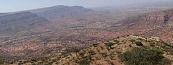
tabia occupies a high position around the Arebay peaks Ekli Imba, Medayq and Addi Shumbolo. The highest peak is 2799 m a.s.l. and the lowest place at the northeast...
16 KB (1,221 words) - 16:36, 3 December 2023

Aregen (redirect from Addi Gotet)
Tembien district of the Tigray Region of Ethiopia. The tabia centre is in Addi Gotet village, located approximately 11 km (6.8 mi) to the west-southwest...
17 KB (1,402 words) - 05:33, 15 September 2023
Hagere Selam (Degua Tembien) (redirect from Addi Selam)
(Tigrinya: ሃገረ ሰላም) is a town in northern Ethiopia. Located on the Mekelle-Abiy Addi regional road, it is located at an elevation of 2650 metres above sea level...
10 KB (873 words) - 11:05, 23 June 2024

Tembien. The highest peak is T'afa (2580 m a.s.l.) and the lowest place Addi Welo (1990 m a.s.l.). From the higher to the lower locations, the following...
16 KB (1,264 words) - 05:23, 26 May 2025
• elevation 2,298 m (7,539 ft) Mouth Afedena River • location Near Afedena in Addi Azmera municipality • coordinates 13°38′49″N 39°18′11″E / 13.647°N 39.303°E...
7 KB (632 words) - 02:12, 23 January 2025

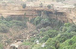
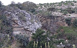
Sesemat exclosure Sesemat exclosure Location Addi Azmera municipality, in Dogu’a Tembien district, Ethiopia Nearest city Hagere Selam Coordinates 13°37′48″N...
5 KB (433 words) - 15:55, 20 June 2024

Afedena exclosure Afedena exclosure Location Addi Azmera municipality, in Dogu’a Tembien district, Ethiopia Nearest city Hagere Selam Coordinates 13°40′08″N...
5 KB (381 words) - 16:43, 4 August 2023

Gebreyohannes at Kerene The main road from Mekelle via Hagere Selam to Abiy Addi runs through the eastern part of the tabia. There are regular bus services...
19 KB (1,549 words) - 09:54, 25 May 2025

transported it up to there. The main road Mekelle – Hagere Selam – Abiy Addi runs at the north and west of the tabia.[citation needed] Almost all children...
15 KB (972 words) - 16:36, 24 May 2025

exclosures are managed by the Ethiotrees project in Inda Sillasie municipality: Addi Meles, near the village of Migichi (64.84 ha) Ch'elaqo, near the homonymous...
24 KB (2,240 words) - 22:11, 23 May 2025

the village of Togogwa (196 ha) Tukhul, near the village of Tukhul, in Addi Azmera municipality (36 ha) Ziban Dake, near the village of Didiben (300 ha)...
9 KB (785 words) - 22:21, 30 January 2025
as follows: Giba River, with tributaries: Ruba Bich’i River, in tabia Addi Azmera Imba Wahti River, draining the eastern part of Mizane Birhan Rubaksa...
23 KB (2,034 words) - 03:50, 27 May 2025

• elevation 2,475 m (8,120 ft) Mouth Giba River • location Tahtay Qarano in Addi Azmera municipality • coordinates 13°34′52″N 39°22′16″E / 13.581°N 39.371°E...
9 KB (773 words) - 23:16, 22 November 2024