Townsville road network is a group of roads that provide access to the urban areas of Townsville in Queensland, Australia, and enable travel between the...
28 KB (2,361 words) - 08:55, 6 May 2024

Flinders Highway, Queensland (redirect from Julia Creek–Kynuna Road)
Network (formerly Auslink). Flinders Highway is a state-controlled national road. It is defined in five sections, as follows: Number 14A, Townsville to...
19 KB (1,272 words) - 00:30, 5 May 2024
10L – Ayr to Townsville 10M – Townsville to Ingham 10N – Ingham to Innisfail 10P – Innisfail to Cairns The following state-controlled roads intersect with...
40 KB (3,348 words) - 15:45, 4 April 2024

Townsville Airport (IATA: TSV, ICAO: YBTL) is a major Australian regional airport that services the city of Townsville, Queensland. The airport is also...
24 KB (2,417 words) - 22:21, 27 May 2024

Spec Road and Little Crystal Creek Bridge, Crystal Creek, are situated in north Queensland, 61 kilometres (38 mi) north of Townsville. Mount Spec Road stretches...
29 KB (4,111 words) - 19:45, 2 August 2023
Townsville Shopping Centre (formally Stockland Townsville) is centrally located in Aitkenvale within the urban area of Townsville, Queensland, Australia...
4 KB (417 words) - 02:47, 18 January 2024

Bruce Highway (category WikiProject Australian Roads articles with a junction list using templates)
to Ayr 10L – Ayr to Townsville 10M – Townsville to Ingham 10N – Ingham to Innisfail 10P – Innisfail to Cairns State-controlled roads that intersect with...
101 KB (5,398 words) - 13:50, 10 May 2024
Mackay road network is a group of roads that provide access to the urban areas of Mackay in Queensland, Australia, and enable travel between the communities...
8 KB (686 words) - 01:49, 10 February 2024
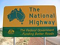
National Highway (Australia) (section Urban components of the national land transport (road) network)
National Land Transport Network) is a system of roads connecting all mainland states and territories of Australia, and is the major network of highways and motorways...
37 KB (2,677 words) - 05:59, 11 January 2024

Townsville Showground is a heritage-listed showground at 72-104 Ingham Road, West End, City of Townsville, Queensland, Australia. It was added to the...
49 KB (7,119 words) - 15:36, 18 January 2024
Gladstone road network is a group of roads that provide access to the urban areas of Gladstone in Queensland, Australia, and enable travel between the...
3 KB (267 words) - 00:03, 5 March 2024
Cairns road network is a group of roads that provide access to the urban areas of Cairns in Queensland, Australia, and enable travel between the communities...
6 KB (528 words) - 21:15, 5 April 2024
Haigslea–Amberley Road Rosewood–Marburg Road Laidley–Plainland Road Forest Hill–Fernvale Road Gatton–Esk Road Gatton–Helidon Road Toowoomba Second Range...
23 KB (1,932 words) - 00:40, 22 January 2024
Crossing Road Kalbar Connection Road Boonah–Fassifern Road Lake Moogerah Road New England Highway Freestone Road Warwick–Yangan Road Warwick–Allora Road Warwick–Killarney...
22 KB (1,802 words) - 22:38, 9 February 2024
("for of such is the kingdom of heaven"); motto of the Cathedral School, Townsville. tanquam ex ungue leonem we know the lion by his claw Said in 1697 by...
2 KB (3,600 words) - 12:56, 18 May 2024
the airline. In 2012, it announced a direct service between Darwin and Townsville, the first Australian airline to offer a non-stop connection between these...
17 KB (1,239 words) - 23:52, 27 May 2024
Marlborough–Sarina Road is a state-controlled district road (number 512) rated as a local road of regional significance (LRRS). It runs from the Bruce...
18 KB (1,471 words) - 05:56, 19 December 2023

Townsville railway station is located on the North Coast line in Queensland, Australia. It serves the city of Townsville. The station has one platform...
4 KB (184 words) - 09:01, 19 November 2023
any state-controlled roads. Australian Roads portal Queensland portal List of numbered roads in Queensland The State Road Network of Queensland (PDF) (Map)...
12 KB (1,052 words) - 01:05, 22 January 2024

Queensland Museum (redirect from Queensland Museum Network)
North Ipswich in Ipswich, East Toowoomba in Toowoomba, and in Townsville City in Townsville. The museum is funded by the Queensland Government. The Queensland...
18 KB (1,566 words) - 04:44, 15 May 2024

the largest outside Brisbane being the Gold Coast, the Sunshine Coast, Townsville, Cairns, Ipswich, and Toowoomba. 28.9% of the state's population were...
121 KB (10,455 words) - 13:40, 26 May 2024
Redcliffe Peninsula road network is a group of roads that provide access to the Redcliffe Peninsula in Queensland, Australia, and enable travel between...
12 KB (1,137 words) - 18:45, 23 April 2024

North Coast railway line, Queensland (redirect from Townsville-Ayr railway line)
Queensland including Nambour, Bundaberg, Gladstone, Rockhampton, Mackay and Townsville. The line though the centre of Rockhampton runs down the middle of Denison...
59 KB (7,352 words) - 03:37, 10 May 2024

Dawson Highway (redirect from Dawson Developmental Road)
upgrade the Townsville to Roma corridor, including sections of the Gregory, Carnarvon and Dawson Highways and surrounding state and council roads, at an estimated...
20 KB (1,305 words) - 02:29, 29 April 2024
numbered roads in Queensland Google (23 June 2023). "Monkland to Tin Can Bay" (Map). Google Maps. Google. Retrieved 23 June 2023. The State Road Network of...
14 KB (1,179 words) - 23:06, 28 March 2024
Gin Road is a state-controlled district road (number 176) in the Bundaberg region of Queensland, Australia. It runs from Bundaberg–Bargara Road (Quay...
12 KB (1,025 words) - 06:36, 14 December 2023
dependent on road transport. There are more than 300 airports with paved runways. Passenger rail transport includes widespread commuter networks in the major...
32 KB (2,838 words) - 01:20, 5 June 2024
Mackay, Rockhamption/Yeppoon, Sunshine Coast Hinterland, Toowoomba, Townsville, Warwick and Whitsundays. Originally, each regional centre had a large...
28 KB (2,574 words) - 10:08, 21 April 2024
D'Aguilar Highway (redirect from Caboolture Connection Road)
the original on 26 January 2017. Retrieved 8 January 2012. The State Road Network of Queensland (PDF) (Map). Queensland Government ©State of Queensland...
22 KB (1,114 words) - 05:42, 20 January 2024

Rail transport in Queensland (redirect from Queensland railway network)
gauge network in the world, consists of: the North Coast Line (NCL) extending 1,680 kilometres (1,040 mi) from Brisbane to Rockhampton, Townsville and Cairns...
38 KB (3,757 words) - 08:22, 24 January 2024