
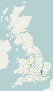
The A149 is commonly known as "The Coast Road" to local residents and tourists, as this road runs along the North Norfolk coast from King's Lynn to Great...
22 KB (3,156 words) - 20:32, 29 January 2024
London Underground station. At its northern end, the A10 meets the A47 and A149 roads south-west of King's Lynn town centre. The route passes through or around...
33 KB (1,834 words) - 10:37, 14 April 2024
River Ant on the A149 road, near Stalham in Norfolk, England within The Broads National Park. Due to height restrictions under the road bridge it is the...
2 KB (136 words) - 20:50, 4 February 2024

the Norfolk Broads, about 15 miles (24 km) north-east of Norwich on the A149 road. For the purposes of local government, it falls within the district of...
4 KB (373 words) - 16:37, 20 July 2023

to the A149 south of Cromer. It is of primary status for the entirety of its route. It is approximately 56 miles (90 km) in length. The road starts as...
11 KB (1,032 words) - 15:56, 16 April 2022

Sheringham (section Roads)
town of Muzillac in the region of Morbihan, Brittany, France. A1082 road A149 road "Town population 2011". Retrieved 25 August 2015. Ordnance Survey (2002)...
26 KB (2,991 words) - 18:49, 21 May 2024

west, and the A149 road to the south. The site is maintained by the National Trust. Free access is possible from the adjoining A149 road or the Norfolk...
6 KB (675 words) - 12:56, 10 February 2024

route being renumbered as the A1064 (Acle to Caister-on-Sea) and part of the A149 (Caister to Great Yarmouth). Another change also dates from 1935. The A47...
39 KB (4,545 words) - 04:24, 14 May 2024
List of A roads in zone 1 in Great Britain beginning north of the River Thames, east of the A1 (roads beginning with 1). "Old Stoke Bridge, Ipswich"....
99 KB (79 words) - 14:43, 23 May 2024
It is situated 12 mi (19 km) north-east of the city of Norwich on the A149 road, and within the Broads National Park. The village is known for its medieval...
8 KB (941 words) - 19:21, 25 April 2023

approximately 3 mi (4.8 km) south-south-east of Cromer. It is located next to the A149 road close to its junction with the A 140. Northrepps Aerodrome opened in October...
4 KB (354 words) - 22:13, 29 September 2022

disused. No major repairs were carried out until 1953–1954, after a new A149 road with a lay-by and kiosk had been built, which cut across the lavender...
17 KB (2,078 words) - 06:02, 14 February 2024

Thurne and Bastwick is at the south end of the bridge which carries the A149 road over that river to the village of Potter Heigham. The civil parish has...
5 KB (454 words) - 20:31, 3 April 2024

called Grove Road and for much of the distance after crossing Roman Road it forms the eastern boundary of Mile End Park. Where the road passes under the...
7 KB (690 words) - 02:46, 24 March 2024

The A11 is a major trunk road in England. It originally ran roughly north east from London to Norwich, Norfolk. It now consists of a short section in Inner...
21 KB (2,166 words) - 21:48, 20 May 2024

B roads are numbered routes in Great Britain of lesser importance than A roads. See the article Great Britain road numbering scheme for the rationale behind...
86 KB (29 words) - 15:49, 17 March 2024
village is Worstead, and is around 3 miles away from North Walsham. The A149 road runs immediately by (but not through) the hamlet, which has been by-passed...
1 KB (70 words) - 17:54, 1 July 2021

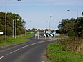
carries the A149 road, with around 7 feet (2.1 m) of headroom, making it only passable by small pleasure craft. During excavations for a new road in 1976...
21 KB (2,522 words) - 12:37, 27 November 2021
English A road entirely in the county of Norfolk. It runs from a junction with the A148 King's Lynn to Cromer Road to a roundabout on the A149 in the North...
4 KB (460 words) - 22:09, 27 March 2024

with about 92,000 visitors annually. Titchwell Marsh is next to the A149 road and buses stop outside the reserve. The main track to the beach is a public...
35 KB (3,834 words) - 16:46, 18 January 2024

houses along the A149 road linking King's Lynn and Hunstanton. The site of the abandoned village is in fields west of the main road, marked by the ruin...
8 KB (985 words) - 08:53, 27 March 2024

civil parish in the English county of Norfolk. It is situated on the A149 road, adjacent to Rollesby Broad and Ormesby Broad, about 12 km (7.5 mi) north-west...
3 KB (243 words) - 02:44, 17 May 2021

also known as the Southend Arterial Road, is a major road in Essex, England. It was constructed as a new arterial road project in the 1920s, linking Romford...
9 KB (1,110 words) - 16:14, 23 October 2023

village over an area of 1,255 acres (5.08 km2). The village straddles the A149 road that links King's Lynn to Great Yarmouth. The community is bordered to...
13 KB (1,768 words) - 21:16, 29 April 2024

Russian federal highways (redirect from Road in Russia)
R298 and R22 in 2018 A-148: Route M27 to Krasnaya Polyana; redesignated as A149 A-153: Nytva - Kudymkar; former R344, absorbed into the R243 in 2023 A-154:...
33 KB (2,028 words) - 16:50, 4 March 2024

its southern end, the canal starts at Wayford Bridge, which carries the A149 road. It heads north-westwards, and soon reaches the junction with Dilham Dyke...
38 KB (4,945 words) - 08:09, 11 February 2022

Broad to its south-east), about 16 miles north-east of Norwich on the A149 road, adjacent to the slightly larger market town of Stalham. Sutton has a...
3 KB (187 words) - 11:42, 1 February 2021

major road in North Yorkshire, and the unitary authority of Middlesbrough, England. It runs from Ingleby Arncliffe to Middlesbrough. The road derives...
5 KB (544 words) - 01:31, 22 September 2023

The A16 road is a principal road of Lincolnshire in the East Midlands region of England, connecting the port of Grimsby and Peterborough, where it meets...
17 KB (1,051 words) - 11:12, 8 September 2023

marshes. Burnham Deepdale's parish church, St Mary's, is adjacent to the A149 road which runs through the village. It is one of 129 surviving round-tower...
6 KB (706 words) - 18:26, 4 January 2024