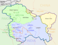
The Actual Ground Position Line (AGPL) divides current positions of Indian and Pakistani military posts and troops along the entire 110 kilometres (68 mi)...
27 KB (2,900 words) - 19:33, 6 March 2025

Pakistani side of the Saltoro Range, which generally follows the Actual Ground Position Line (AGPL). The Saltoro Range, of which western slopes are held by...
11 KB (980 words) - 12:57, 14 February 2025
The Line of Actual Control (LAC), in the context of the Sino-Indian border dispute, is a notional demarcation line that separates Indian-controlled territory...
52 KB (4,972 words) - 03:34, 24 May 2025

which western slopes are held by Pakistan and separated by the Actual Ground Position Line (AGPL) the higher peaks and passes are held by India all of which...
9 KB (752 words) - 10:44, 17 February 2025
India-Pakistan cease fire line in Kashmir known as the Line of Control (LoC). The India–Pakistan AGPL (Actual Ground Position Line), begins from the NJ9842...
10 KB (1,069 words) - 13:27, 31 December 2024

interior to Siachen, a glacier, helipad and battleground near the Actual Ground Position Line between India and Pakistan. Thoise is nearly 16 km from Hundar...
8 KB (646 words) - 16:48, 18 July 2024
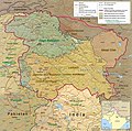
brigade) of XIV Corps of Indian Army which protects 110 km long Actual Ground Position Line (AGPL) with at least 108 forward military outposts and artillery...
14 KB (1,465 words) - 20:06, 19 February 2025
battleground and a disputed territory between India and Pakistan. The Actual Ground Position Line (AGPL) divides the region held by India and Pakistan in the disputed...
6 KB (459 words) - 17:33, 20 February 2025
Karakoram range. It is located west of the Siachen Glacier near the Actual Ground Position Line between India and Pakistan. Ghent Kangri was first climbed on...
4 KB (285 words) - 14:35, 16 October 2024
which western slopes are held by Pakistan and separated by the Actual Ground Position Line (AGPL) the higher peaks and passes are held by India all of which...
6 KB (496 words) - 14:57, 10 May 2025
Army operation that aimed to capture a high point along the Actual Ground Position Line (AGPL) on the Siachen Glacier in June 1987. Prior to this operation...
23 KB (2,956 words) - 23:03, 1 May 2025
ascent. List of Ultras of the Western Himalayas Siachen conflict Actual Ground Position Line Indira Col Sia La Ghent Kangri Saltoro Kangri Bilafond La Chumik...
4 KB (344 words) - 08:09, 7 January 2025
media related to Line of Control. India–Pakistan relations Transport between India and Pakistan Actual Ground Position Line – the line of separation near...
54 KB (4,467 words) - 02:06, 7 May 2025

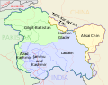
Indira Col Borders Actual Ground Position Line (AGPL) India–Pakistan International Border (IB) Line of Control (LoC) Line of Actual Control (LAC) Sir Creek...
19 KB (2,036 words) - 08:58, 8 May 2025
Chumik Kangri Borders Actual Ground Position Line (AGPL) India–Pakistan International Border {IB) Line of Control {LoC) Line of Actual Control (LAC) Sir Creek...
6 KB (418 words) - 05:06, 19 December 2024

Operation Safed Sagar (section Ground operations)
ends at LAC Borders Actual Ground Position Line (AGPL) India–Pakistan International Border (IB) Line of Control (LoC) Line of Actual Control (LAC) Sir Creek...
7 KB (743 words) - 22:57, 1 May 2025
1963 through the Sino-Pakistan Agreement, and a border based on actual ground positions was recognized as the international border by China and Pakistan...
20 KB (2,040 words) - 18:49, 17 February 2025

located in the remote reaches of the Karakoram. It lies on the Actual Ground Position Line, dividing Indian-controlled territory in the Siachen region from...
7 KB (674 words) - 23:31, 31 January 2025
which western slopes are held by Pakistan and separated by the Actual Ground Position Line (AGPL) the higher peaks and passes are held by India all of which...
10 KB (973 words) - 20:01, 15 February 2025
the tripoint of India, Pakistan, and China. The India-Pakistan Actual Ground Position Line (AGPL) in the Siachen area ends near the pass. It is possible...
15 KB (1,402 words) - 10:34, 26 April 2025

administered by Pakistan as part of Gilgit-Baltistan since 1947 (see Durand Line). India co-hosts the joint ceremonies with the neighbouring nations at the...
28 KB (1,107 words) - 19:38, 20 May 2025
North and East and Line Of Control (LOC) and The India–Pakistan AGPL Actual Ground Position Line. That divides current positions of Indian and Pakistani...
4 KB (202 words) - 09:34, 19 May 2025
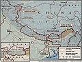
Hodgson Baltoro Glacier Saltoro Kangri Sia La Bilafond La Gyong La Actual Ground Position Line 2016 Siachen Glacier avalanche Siachen Muztagh From map: "THE...
44 KB (4,182 words) - 12:38, 12 May 2025
Siachen conflict (section Ground situation)
their respective posts is being increasingly referred to as the Actual Ground Position Line (AGPL). Despite the high cost India maintains presence, as Pakistani...
73 KB (6,952 words) - 15:08, 16 May 2025
AGPL may refer to: Actual Ground Position Line, the current line dividing Indian and Pakistani forces in the Siachen Glacier GNU Affero General Public...
287 bytes (72 words) - 16:51, 26 February 2024

disputed sections, listed from north to south: Actual Ground Position Line (AGPL) - separates the current positions of Indian and Pakistani military posts and...
21 KB (1,845 words) - 16:44, 28 May 2025

Bahadur Post near the Chulung Glacier in the southern part of Actual Ground Position Line in Siachen. Pakistani forces attempted to capture India's Bahadur...
15 KB (1,503 words) - 23:07, 23 April 2025
after India and Pakistan declared a ceasefire along the Line of Control Actual Ground Position Line in November 2003. Ten soldiers died under snow after...
7 KB (529 words) - 14:02, 27 January 2025
of the pass near Indira Col in the Siachen Muztagh, where the Actual Ground Position Line between Indian and Pakistani forces meets the border with China...
10 KB (906 words) - 07:53, 21 March 2025
Borders Line of Actual Control Line of Control Actual Ground Position Line Other Curious BRO roadsigns...
7 KB (710 words) - 21:29, 4 January 2025