The Army Geospatial Center (AGC) (formerly Topographic Engineering Center (TEC), part of the ERDC) is a Major Subordinate Command of the United States...
16 KB (1,293 words) - 04:47, 28 April 2025

The Army Geospatial Information Center (Portuguese: Centro de Informação Geoespacial do Exército; CIGeoE) is the military geographical, cartographical...
4 KB (271 words) - 15:31, 1 November 2024

Laboratory (ITL) Geospatial Research Laboratory (GRL) formerly the Topographic Engineering Center U.S. Army Forces Command (FORSCOM) U.S. Army Futures Command...
8 KB (778 words) - 02:18, 4 May 2025

the Defence Geospatial Intelligence Fusion Centre (DGIFC) USA: National Geospatial-Intelligence Agency (NGA) USA: Army Geospatial Center (AGC) USA: National...
20 KB (2,162 words) - 17:23, 28 May 2025
TerraGo (section US Army Geospatial Center)
Reader. The US Army Geospatial Center distributes a wide variety of products, including USGS topos, and a variety of National Geospatial-Intelligence Agency...
4 KB (361 words) - 00:47, 15 April 2025

The National Geospatial-Intelligence Agency (NGA) is a combat support agency within the United States Department of Defense whose primary mission is collecting...
52 KB (4,448 words) - 05:29, 19 May 2025

field offices. Army Geospatial Center (AGC) — provides geospatial information, standards, systems, support, and services across the Army and the Department...
108 KB (10,047 words) - 14:03, 28 May 2025
in its first eight years. The Topographic Engineering Center became the Army Geospatial Center (AGC) and started reporting directly to the Corps of Engineers...
6 KB (406 words) - 06:24, 14 April 2025

Afghanistan: An Annotated Bibliography."[dead link] US Army Corps of Engineers, Army Geospatial Center. Hansen, Roger D. "Karez (Qanats) of Turpan, China"...
88 KB (11,291 words) - 09:34, 28 May 2025
spatial awareness, and controlling drones. On October 14, 2014, U.S. Army Geospatial Center recommended AFRL's Android Team Awareness Kit (ATAK), over the world-leader...
21 KB (2,000 words) - 15:47, 14 May 2025
former public bodies in th UK Topographic Engineering Center, former name of the US Army Geospatial Center Treaty establishing the European Community Transitional...
3 KB (337 words) - 16:26, 15 May 2025

Geology, Geography and Earth Science. Alexandria, VA: US Army Corps of Engineers, Army Geospatial Center. Yemen country profile. Library of Congress Federal...
15 KB (2,004 words) - 07:29, 21 December 2024

37:100–109; https://doi.org/10.1111/gto.12350 US Army, Corps of Engineers Army Geospatial Center webpage on the crisis of Mount Merapi, with data, citations...
49 KB (4,998 words) - 15:25, 23 May 2025
a financial company Army Geospatial Center, part of the US Army Corps of Engineers Adjutant General's Corps, in the British Army A retired US Navy hull...
2 KB (270 words) - 05:42, 1 October 2024

Archived 11 January 2020 at the Wayback Machine. US Army Corps of Engineers, Army Geospatial Center. July 2010. Heinl, Robert (1996). Written in Blood:...
270 KB (25,075 words) - 06:20, 29 May 2025
which was redesignated as the National Geospatial-Intelligence Agency (NGA) in 2003. The major task of the Army Map Service was the compilation, publication...
16 KB (2,092 words) - 14:23, 27 March 2025
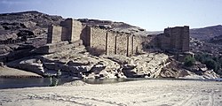
Geology, Geography and Earth Science. Alexandria, VA: US Army Corps of Engineers, Army Geospatial Center. Wikimedia Commons has media related to Ma'rib Dam...
19 KB (2,297 words) - 12:30, 19 April 2025

and is the Army's premier provider of intelligence products. Army Geospatial Intelligence Battalion (AGB) Located in the National Geospatial-Intelligence...
22 KB (1,612 words) - 12:17, 29 May 2025

Geology, Geography and Earth Science. Alexandria, VA: US Army Corps of Engineers, Army Geospatial Center. Page 41. IEA Key World Energy Statistics Statistics...
9 KB (518 words) - 04:53, 5 January 2025

Development Laboratories, Topographic Engineering Center (now known as the Army Geospatial Center), United States Army Corps of Engineers, in Alexandria, VA. Includes...
32 KB (3,162 words) - 11:58, 30 May 2025

United States Army Geospatial Intelligence Battalion (GEOINT Battalion or AGB), previously known as the 3rd Military Intelligence Center, is a military...
12 KB (829 words) - 00:36, 27 September 2023

Yemen's Geology, Geography, and Earth Science, Alexandria, VA: Army Geospatial Center, U.S. Army Corps of Engineers Robert D. Burrowes (2010). Historical Dictionary...
23 KB (1,939 words) - 04:01, 22 March 2025

Battalion, Fort Sam Houston, Texas Army Forces, Honduras (Joint Task Force Bravo), Soto Cano Air Base, Honduras Geospatial Planning Cell, 512th Engineer Detachment...
17 KB (1,475 words) - 07:18, 14 April 2025
Nett Warrior (category Wikipedia articles incorporating text from the United States Army)
fielded by the U.S. Army Rangers and members of the 10th Mountain Division. On 14 October 2014, the U.S. Army Geospatial Center recommended AFRL's Android...
9 KB (1,269 words) - 00:27, 15 April 2025
The Geospatial Research Laboratory (GRL) is a component of the Engineer Research and Development Center (ERDC), a US Army Corps of Engineers (USACE) laboratory...
6 KB (446 words) - 17:04, 13 April 2025

Collectors (19 weeks), Geospatial Intelligence Imagery Analyst (22 weeks), UAS Operators (23 weeks), and Special Agents with United States Army Counterintelligence...
7 KB (383 words) - 17:29, 13 April 2025
Resources, ESRI Press, 2002 Spatial Hydrology GIS Lounge ArcNews Online US Army Geospatial Center — For information on OCONUS surface water and groundwater....
8 KB (896 words) - 06:30, 14 April 2025

profession. IGRAC International Groundwater Resources Assessment Centre US Army Geospatial Center — For information on OCONUS surface water and groundwater....
62 KB (8,006 words) - 01:55, 26 May 2025

Fort Belvoir (category United States Army posts)
National Geospatial-Intelligence Agency. Fort Belvoir is home to the Virginia National Guard's 29th Infantry Division (Light) and elements of ten Army Major...
18 KB (1,754 words) - 04:27, 24 May 2025
(Enroute) - VFR Supplement United States (PDF). St. Louis, Missouri: National Geospatial-Intelligence Agency. 2018. Archived (PDF) from the original on 2021-04-20...
16 KB (330 words) - 23:47, 21 February 2025