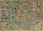
Carta marina et descriptio septemtrionalium terrarum (Latin for Marine map and description of the Northern lands; commonly abbreviated Carta marina) is...
8 KB (743 words) - 04:16, 19 January 2024

kraken, various sea-monsters were illustrated on his famous map, the Carta marina (1539). Modern writers have since tried to interpret various sea creatures...
110 KB (10,931 words) - 05:53, 25 September 2024

Waldseemüller's Carta marina navigatoria (1522), revised by Laurentius Fries, has the morsus moved to the Davis Strait. Bishop Olaus Magnus's Carta Marina map of...
10 KB (1,110 words) - 13:55, 6 July 2024
Works by Olaus Magnus in digital library Polona Carta Marina James Bell Ford Library, Minnesota Carta Marina satellite images The Plymouth Marine Laboratory...
9 KB (894 words) - 13:08, 31 July 2024

at the Library of Congress Carta Marina of 1516, Speaker: Chet Van Duzer Video from the Library of Congress Carta Marina of 1516, digital copy at the...
15 KB (1,842 words) - 01:08, 8 June 2024

Moskstraumen into his detailed report on the Nordic countries and their map, Carta Marina (1539). He attributed the whirlpool to divine forces and mentioned that...
12 KB (1,243 words) - 09:53, 5 September 2024

any physical similarities to the pig. The creatures appeared in the Carta marina, and were depicted in accompanying wood carvings, as fantastical beasts...
4 KB (378 words) - 17:43, 18 September 2024
The maelstrom off Norway as illustrated by Olaus Magnus on the Carta Marina, 1539....
24 KB (2,902 words) - 18:35, 22 September 2024

Saami, and morse in French. Olaus Magnus, who depicted the walrus in the Carta Marina in 1539, first referred to the walrus as the ros marus, probably a Latinization...
70 KB (7,501 words) - 21:16, 25 September 2024
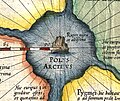
Part of the Carta marina of 1539 by Olaus Magnus, depicting the location of magnetic north vaguely conceived as "Insula Magnetu[m]" (Latin for "Island...
2 KB (227 words) - 15:30, 6 May 2024

cartographer Olaus Magnus located Bjarmaland in the Kola Peninsula in his Carta marina et descriptio septentrionalium terrarum (1539), while Swedish humanist...
12 KB (1,388 words) - 16:57, 12 September 2024

Mauro map (c. 1450), the Erdapfel (c. 1490, &Martin Waldseemüller's Carta marina (1516). A detail from "Map of the Holy Land with Armenia" from the Chronica...
169 KB (16,086 words) - 14:17, 26 September 2024

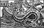
Plate c. 1544 depicting various sea monsters; compiled from the Carta marina....
14 KB (1,459 words) - 16:25, 26 September 2024
Carta marina showing Finnish economy, with the captions Hic fabricantur naves and Hic fabricantur bombarde abbreviated...
61 KB (7,051 words) - 22:20, 26 September 2024
serpents and other various marine monsters on his illustrated map, the Carta marina. In his 1555 work History of the Northern Peoples, Olaus gives the following...
21 KB (2,295 words) - 16:03, 7 September 2024
June 14, 2021. Casarosa, Enrico [@sketchcrawl] (June 26, 2021). "The Carta Marina inspired our map ... We called the island in our movie Isola del Mare...
110 KB (9,398 words) - 05:53, 23 September 2024
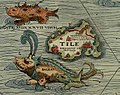
Thule On the Ocean location Thule as Tile on the Carta marina of 1539 by Olaus Magnus, where it is shown located to the northwest of the Orkney islands...
40 KB (5,164 words) - 17:20, 26 August 2024

fishing otter. One of the motifs of Magnus's 1539 map of Scandinavia, Carta marina, is an otter fetching a fish for its master, who is ready with a knife...
10 KB (1,206 words) - 23:18, 6 April 2024

Danish). Copenhagen: Politikens Forlag. p. 138. ISBN 87-567-1143-3. Carta Marina features the coat of arms. Stål, Harry (1976), Ortnamn och ortnamnsforskning...
14 KB (1,402 words) - 03:15, 1 September 2024

Coat of arms of Muscovy on the Carta marina (1539)...
42 KB (4,480 words) - 07:11, 21 September 2024

Possibly the earliest depictions of a polar bear on a map is the Swedish Carta marina of 1539, which has a white bear on Iceland or "Islandia". A 1544 map...
95 KB (12,404 words) - 23:26, 3 September 2024
Mustsåår in 1530. Olaus Magnus spelled it as Mostesar in his 1539 map, Carta Marina, where the castle appeared separately as "Korsholm". In 1606–1611, it...
14 KB (1,117 words) - 11:59, 31 May 2024

currents. The first reasonably reliable map of northern Europe, the Carta marina of 1539, represents the Norwegian Sea as coastal waters and shows nothing...
49 KB (6,094 words) - 12:33, 17 September 2024

Birkarls trading as depicted on the Carta Marina (1539)...
14 KB (1,393 words) - 14:28, 19 September 2024
Magician The Maine Maite Perroni Manowar Maraaya Marcelo Falcão Marco Carta Marina and the Diamonds Mark Ronson (2003-2007) Marshmello (Via Spinnin' Records)...
25 KB (2,501 words) - 08:19, 20 September 2024

rebranded as Swedbank. Europe in 1097 Europe in 1430 Europe in 1470 Carta marina of the Baltic Sea region (1539) In the Patrician series of trading simulation...
179 KB (13,115 words) - 10:18, 26 September 2024


16th century, in particular: The Olaus Magnus map of the North, the Carta marina The Caerte van Oostland of Cornelis Anthoniszoon Claudius Clavus-type...
18 KB (2,384 words) - 04:27, 22 August 2024

A coastal area of Ostrobothnia featuring in Olaus Magnus' 1539 map, Carta marina....
10 KB (1,206 words) - 02:33, 8 July 2024

Žaltys and the Holy Fire are depicted in Olaus Magnus' Carta Marina, above the inscription LITVANIE PARS...
2 KB (166 words) - 15:41, 4 September 2023