
question Replaceable? no Fair useFair use of copyrighted material in the context of The Burning Shore//en.wikipedia.org/wiki/File:TheBurningShore.jpgtrue...
(244 × 370 (38 KB)) - 05:38, 30 October 2016

Creative Commons Attribution-Share Alike 4.0 truetrue English Men burning a boat on the shores of Zanzibar object has role: photographer author name string:...
(3,024 × 3,024 (2.58 MB)) - 17:23, 16 September 2020

dogg 740×615×8 (87375 bytes) Caption: [[Battle of Midway]], June 1942. Burning oil tanks on Sand Island, Midway, following the Japanese air attack delivered...
(2,100 × 1,650 (1.14 MB)) - 13:13, 5 November 2023

Pogradec.jpg File:031 2015 12 29 Wiki Loves Earth 2016.jpg File:Белоглав лешояд - 3.jpg File:Phandar Valley Wonder Valley.jpg File:The burning mountain...
(1,239 × 1,752 (26.39 MB)) - 15:38, 1 January 2024

Pogradec.jpg File:031 2015 12 29 Wiki Loves Earth 2016.jpg File:Белоглав лешояд - 3.jpg File:Phandar Valley Wonder Valley.jpg File:The burning mountain...
(1,239 × 1,752 (3.5 MB)) - 15:38, 1 January 2024

English Tanker SS R. P. Resor burns off the shore of New Jersey after it was sunk by U-578...
(2,932 × 1,940 (1.98 MB)) - 12:11, 7 May 2022

Spectroradiometer (MODIS) on board NASA’s Aqua satellite captured fires burning in British Columbia, Canada and western Montana, USA. determination method:...
(1,897 × 1,473 (414 KB)) - 22:28, 9 January 2024

File:CK12 Earth Science.pdf (matches file content)
http://upload.wikimedia.org/wikipedia/commons/thumb/9/91/Brujula.jpg/800px-Brujula.jpg, , License: GNU Free Documentation) Figure 2: A compass rose...
(1,275 × 1,650 (130.11 MB)) - 14:19, 18 January 2024

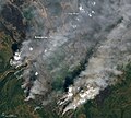
English Fire burning near Enterprise and Hay River, Northwest Territories...
(2,202 × 1,835 (2.19 MB)) - 07:21, 12 September 2023
English Fire burning near Enterprise and Hay River, Northwest Territories (Captioned)...
(720 × 650 (410 KB)) - 07:21, 12 September 2023

0falsefalse English A tinted lithograph of Mount Egmont from the North Shore of Cooke's Strait, from the drawing by Charles Heaphy (1820-1881), 1841...
(1,024 × 739 (895 KB)) - 09:42, 7 April 2024

Spectroradiometer (MODIS) on board NASA’s Terra satellite acquired a true-color image fires burning in the Gironde department of France. determination method: SHA-1...
(2,409 × 2,085 (568 KB)) - 23:08, 13 May 2023

works of this file: Ninety-Three advertisement 1.jpg Ninety-Three advertisement 2.jpg Ninety-Three advertisement 3.jpg Ninety-Three advertisement 4.jpg...
(1,894 × 2,887 (9.29 MB)) - 06:07, 27 March 2022

Derivative works of this file: The Mystery of the Sea (5).jpg...
(1,872 × 2,872 (14.99 MB)) - 10:11, 26 September 2021

https://creativecommons.org/publicdomain/mark/1.0/PDMCreative Commons Public Domain Mark 1.0falsefalse English Azerbaijani ساسانی.jpg...
(1,166 × 1,645 (27.92 MB)) - 04:42, 27 August 2022

Shot in Chennai (Tamilnadu, India) 11 kms off sea-shore ; Latitude- 13°02'29" N ; Longitude - 80°13'60" E ; Elevation from sea level – 13 m. I, the copyright...
(2,560 × 1,920 (986 KB)) - 07:46, 7 September 2020
Shot in Chennai (Tamilnadu, India) 11 kms off sea-shore ; Latitude- 13°02'29" N ; Longitude - 80°13'60" E ; Elevation from sea level – 13 m. I, the copyright...
(2,560 × 1,920 (1.27 MB)) - 07:46, 7 September 2020

Shot in Chennai (Tamilnadu, India) 13 kms off sea-shore ; Latitude- 12°59'02" N ; Longitude- 80°14'50" E ; Elevation from sea level – 13 m. I, the copyright...
(2,560 × 1,920 (1.22 MB)) - 07:46, 7 September 2020

Shot in Chennai (Tamilnadu, India) 11 kms off sea-shore ; Latitude- 13°02'29" N ; Longitude - 80°13'60" E ; Elevation from sea level – 13 m. I, the copyright...
(384 × 384 (17 KB)) - 07:46, 7 September 2020

Shot in Chennai (Tamilnadu, India) 4.5 kms off sea-shore ; Latitude-13°02'20" N ; Longitude- 80°13'43" E ; Elevation from sea level - 6.7 m I, the copyright...
(1,920 × 2,560 (1.54 MB)) - 07:27, 7 September 2020

Shot in Chennai (Tamilnadu, India) 11 kms off sea-shore ; Latitude- 13°02'29" N ; Longitude - 80°13'60" E ; Elevation from sea level – 13 m. I, the copyright...
(1,920 × 2,560 (1.41 MB)) - 07:46, 7 September 2020

Shot in Chennai (Tamilnadu, India) 4.5 kms off sea-shore ; Latitude-13°02'20" N ; Longitude- 80°13'43" E ; Elevation from sea level – 6.7 m. I, the copyright...
(480 × 390 (30 KB)) - 09:01, 29 April 2023

Shot in Chennai (Tamilnadu, India) 11 kms off sea-shore ; Latitude- 13°02'29" N ; Longitude - 80°13'60" E ; Elevation from sea level – 13 m. I, the copyright...
(2,560 × 1,920 (1.35 MB)) - 07:46, 7 September 2020

Shot in Chennai (Tamilnadu, India) 4.5 kms off sea-shore ; Latitude-13°02'20" N ; Longitude- 80°13'43" E ; Elevation from sea level - 6.7 m I, the copyright...
(275 × 272 (46 KB)) - 09:01, 29 April 2023

Shot in Chennai (Tamilnadu, India) 4.5 kms off sea-shore ; Latitude-13°02'20" N ; Longitude- 80°13'43" E ; Elevation from sea level – 6.7 m. I, the copyright...
(426 × 494 (36 KB)) - 09:01, 29 April 2023

Shot in Chennai (Tamilnadu, India) 4.5 kms off sea-shore ; Latitude-13°02'20" N ; Longitude- 80°13'43" E ; Elevation from sea level - 6.7 m I, the copyright...
(932 × 771 (262 KB)) - 09:18, 29 April 2023

Shot in Chennai (Tamilnadu, India) 4.5 kms off sea-shore ; Latitude-13°02'20" N ; Longitude- 80°13'43" E ; Elevation from sea level - 6.7 m I, the copyright...
(384 × 340 (16 KB)) - 07:27, 7 September 2020

Shot in Chennai (Tamilnadu, India) 4.5 kms off sea-shore ; Latitude-13°02'20" N ; Longitude- 80°13'43" E ; Elevation from sea level – 6.7 m. I, the copyright...
(1,920 × 2,560 (1.61 MB)) - 07:27, 7 September 2020

File:Small boat and swarm defense a gap study (IA smallboatndswarm109453912).pdf (matches file content)
machine gun (from http://en.wikipedia.org/wiki/Image:Twin_M2HB_machine_gun.jpg) ............20 AR-VAST conceptual image showing synthetic tracers and FIAC...
(1,275 × 1,650 (1.96 MB)) - 09:48, 4 October 2020

File:The two paths (IA twopaths00dalt).pdf (matches file content)
jbBf M is ?( / N«s«agR ^11 fl lj M r<\ j^f'— &• wkh[ BB& I Jpg’ £:? ;> 1 . f | W?A Hw ft g.£$fe flj| »& 1 J B®/ mi i I , ...
(1,316 × 2,037 (10.35 MB)) - 04:33, 24 July 2020