
The Front Range Urban Corridor is an oblong region of urban population located along the eastern face of the Southern Rocky Mountains, encompassing 18...
25 KB (1,064 words) - 23:21, 18 July 2025

Wyoming south to Pueblo, Colorado. This urban corridor benefits from the weather-moderating effect of the Front Range mountains, which help block prevailing...
20 KB (1,959 words) - 09:50, 11 July 2025
Fort Smith metropolitan area (parts of Arkansas and Oklahoma) Front Range Urban Corridor (parts of Colorado and Wyoming) Greater Grand Forks (part of Minnesota...
54 KB (3,845 words) - 16:19, 2 August 2025
Colorado (section Front Range)
is the capital, the most populous city, and the center of the Front Range Urban Corridor. Colorado Springs is the second-most populous city of the state...
214 KB (18,836 words) - 17:20, 28 July 2025

Denver–Aurora–Lakewood, CO Metropolitan Statistical Area and the Front Range Urban Corridor. The city is named for the Greenwood Ranch. The area was developed...
20 KB (1,499 words) - 02:07, 3 August 2025
the Colorado Springs, CO Metropolitan Statistical Area and the Front Range Urban Corridor. In 1968, officials in Green Mountain Falls conducted a resurvey...
10 KB (774 words) - 01:49, 8 July 2025

part of the Greeley, CO Metropolitan Statistical Area and the Front Range Urban Corridor. Initially named McKissick for the mine owner, Frederick was renamed...
14 KB (1,186 words) - 01:48, 8 July 2025

Denver–Aurora–Lakewood, CO Metropolitan Statistical Area and the Front Range Urban Corridor. It is located in the valley of Clear Creek west of Denver, on...
12 KB (913 words) - 01:47, 8 July 2025

Denver–Aurora–Lakewood, CO Metropolitan Statistical Area and the Front Range Urban Corridor. Englewood is located immediately south of Denver in the South...
29 KB (2,351 words) - 08:25, 27 July 2025

Southern Rocky Mountain Front Front Range Urban Corridor Southeast Wyoming North Central Colorado Urban Area South Central Colorado Urban Area Northern New...
24 KB (852 words) - 20:09, 18 July 2025

of the Fort Collins, CO Metropolitan Statistical Area and the Front Range Urban Corridor. A popular summer resort and the location of the headquarters...
42 KB (3,867 words) - 07:45, 19 July 2025
Denver–Aurora–Lakewood, CO Metropolitan Statistical Area and the Front Range Urban Corridor. The Westminster Municipal Center is located 9 miles (14 km) north-northwest...
30 KB (2,266 words) - 19:47, 24 July 2025

part of the Denver-Aurora, CO Combined Statistical Area and the Front Range Urban Corridor. Erie is located just west of Interstate 25, with easy access...
16 KB (1,496 words) - 01:47, 8 July 2025

part of the Denver-Aurora, CO Combined Statistical Area and the Front Range Urban Corridor. The Coal Creek, Colorado Territory, post office operated from...
18 KB (626 words) - 23:01, 23 July 2025

Douglas County, Colorado (category Front Range Urban Corridor)
Colorado Outline of Colorado Douglas County search and rescue Front Range Urban Corridor "Annual Estimates of the Resident Population for Counties: April...
26 KB (2,094 words) - 18:08, 4 August 2025

Denver, Douglas, and Jefferson. The Denver region is part of the Front Range Urban Corridor and its metropolitan planning organization is the Denver Regional...
22 KB (1,375 words) - 13:10, 31 July 2025

part of the Greeley, CO Metropolitan Statistical Area and the Front Range Urban Corridor. Grover is located at 40°52′6″N 104°13′34″W / 40.86833°N 104...
10 KB (688 words) - 01:49, 8 July 2025

part of the Greeley, CO Metropolitan Statistical Area and the Front Range Urban Corridor. The town is named after Benjamin Harrison Eaton, a pioneer of...
14 KB (1,184 words) - 01:46, 8 July 2025

Denver–Aurora–Lakewood, CO Metropolitan Statistical Area and the Front Range Urban Corridor. The town is bordered by the cities of Aurora and Centennial....
11 KB (697 words) - 01:48, 8 July 2025

Arvada, Colorado (category Front Range Urban Corridor)
Denver–Aurora–Lakewood, CO Metropolitan Statistical Area and the Front Range Urban Corridor. The Olde Town Arvada historic district is 7 miles (11 km) northwest...
31 KB (2,085 words) - 18:26, 26 July 2025
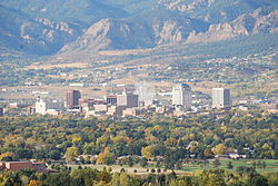
residents in 2020, and the second-most prominent city of the Front Range Urban Corridor. It is located in east-central Colorado on Fountain Creek, 70...
140 KB (10,934 words) - 22:56, 3 August 2025

of the Greeley, Colorado Metropolitan Statistical Area and the Front Range Urban Corridor. The city was named for Lieutenant Lancaster Lupton, who built...
13 KB (1,042 words) - 01:48, 8 July 2025

part of the Greeley, CO Metropolitan Statistical Area and the Front Range Urban Corridor. The town was named for Jacob Firestone, a landowner. The town...
13 KB (953 words) - 15:54, 31 July 2025

part of the Greeley, CO Metropolitan Statistical Area and the Front Range Urban Corridor. The city name's is an amalgamation of the names of Daisy Baum...
12 KB (806 words) - 21:02, 20 July 2025
Interstate 25 (redirect from I-25 corridor)
The I-25 corridor is mainly rural, especially in Wyoming, excluding the Albuquerque metropolitan area and the Front Range urban corridor from Pueblo...
21 KB (1,962 words) - 17:19, 27 July 2025

part of the Greeley, CO Metropolitan Statistical Area and the Front Range Urban Corridor. It is surrounded by the cities of Greeley and Evans, Colorado...
13 KB (678 words) - 04:36, 29 July 2025

serving metropolitan Denver, Colorado, as well as the greater Front Range Urban Corridor. At 33,531 acres (52.4 sq mi; 135.7 km2), it is the largest airport...
113 KB (7,369 words) - 01:13, 2 August 2025

re-establishing a passenger rail connection spanning Colorado's Front Range Urban Corridor via the Front Range Passenger Rail Project. In 2024, the project was granted...
30 KB (2,587 words) - 00:24, 29 June 2025
Gilpin County, Colorado (category Front Range Urban Corridor)
Colorado List of statistical areas in Colorado Outline of Colorado Front Range Urban Corridor "State & County QuickFacts". United States Census Bureau. Retrieved...
12 KB (768 words) - 17:54, 20 July 2025

Weld County, Colorado Colorado metropolitan areas Front Range Urban Corridor North Central Colorado Urban Area Denver-Aurora-Boulder, CO Combined Statistical...
13 KB (419 words) - 01:51, 8 July 2025