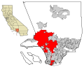
A geocode is a code that represents a geographic entity (location or object). It is a unique identifier of the entity, to distinguish it from others in...
36 KB (3,245 words) - 05:27, 9 July 2025
Address geocoding, or simply geocoding, is the process of taking a text-based description of a location, such as an address or the name of a place, and...
29 KB (3,768 words) - 01:25, 21 July 2025
opposite of forward geocoding (often referred to as address geocoding or simply "geocoding"), hence the term reverse. Reverse geocoding permits the identification...
6 KB (853 words) - 16:24, 2 June 2025
ISO 3166-2 (redirect from ISO geocode)
states and dependent territories List of terms for administrative divisions Geocode "ISO 3166-2". International Organization for Standardization (ISO). "Country...
51 KB (678 words) - 14:15, 5 July 2025

International Territorial Level (ITL) is a geocode standard for referencing the subdivisions of the United Kingdom for statistical purposes, used by the...
36 KB (1,272 words) - 19:33, 4 March 2025
What3words (category Geocodes)
What3words (stylized as what3words) is a proprietary geocode system designed to identify any location on the surface of Earth with a resolution of approximately...
29 KB (2,677 words) - 00:29, 5 June 2025

Geohash (category Geocodes)
Geohash is a public domain geocode system invented in 2008 by Gustavo Niemeyer which encodes a geographic location into a short string of letters and...
26 KB (2,703 words) - 07:07, 2 August 2025
the Interior, OCLC 20706997. Geocode coords estimated based on description in National Register nomination form. Geocode coords estimated based on description...
46 KB (460 words) - 18:04, 25 May 2025

for the French nomenclature d'unités territoriales statistiques) is a geocode standard for referencing the administrative divisions of countries for...
31 KB (183 words) - 05:26, 27 June 2025
Geotagged photograph (redirect from Geocoded Photo)
entry of tags such as city, postal code or a street address. Geocoding and reverse geocoding can be used to convert between locations and addresses. Manual...
13 KB (1,524 words) - 04:16, 19 October 2024
Maidenhead Locator System (category Geocodes)
The Maidenhead Locator System (a.k.a. QTH Locator and IARU Locator) is a geocode system used by amateur radio operators to succinctly describe their geographic...
16 KB (1,933 words) - 23:59, 7 June 2025

Discrete global grid (redirect from List of geodesic-geocoding systems)
this context, it is common also to use a specific DGG as foundation for geocoding standardization. In the context of a spatial index, a DGG can assign unique...
43 KB (3,199 words) - 03:26, 5 May 2025
a succinct and precise identifier of buildings in Singapore, akin to a geocode. For example, in Google Maps and Citymapper, the user can conveniently...
7 KB (627 words) - 14:25, 3 April 2025

International Territorial Level (ITL) is a geocode standard for referencing the subdivisions of the United Kingdom for statistical purposes, used by the...
5 KB (469 words) - 19:37, 17 July 2024

Postal addresses in the Republic of Ireland (redirect from Irish Geocodes)
A postal address in Ireland is a place of delivery defined by Irish Standard (IS) EN 14142-1:2011 ("Postal services. Address databases") and serviced by...
52 KB (4,751 words) - 12:00, 22 June 2025
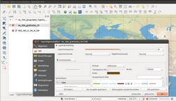
in Python or C++ extend QGIS's capabilities. Plugins can geocode using the Google Geocoding API, perform geoprocessing functions similar to those of the...
10 KB (915 words) - 06:23, 17 July 2025

analysis, simply as Regions. International Territorial Level (ITL) is a geocode standard for referencing the subdivisions of the United Kingdom for statistical...
34 KB (2,856 words) - 08:21, 22 July 2025
Ayutthaya Province, Thailand, differed only by the Thai spelling and the geocode Amphoe Bang Sai (1404) (บางไทร) Amphoe Bang Sai (1413) (บางซ้าย) This disambiguation...
328 bytes (70 words) - 03:11, 17 June 2023
position expressed in latitude and longitude is also a relative location. Geocode – Code that represents a geographic entity (location or object) Geographical...
3 KB (380 words) - 19:36, 21 July 2025
Geocoder (Ruby) is a geocoding library for Ruby. Geocoding helps to enhance webpages by presenting location relevant information to the user. When used...
7 KB (696 words) - 13:38, 3 January 2025
Natural Area Code (category Geocodes)
also called Universal Address, is a geocode generated by the Natural Area Coding System - a public domain geocode system for identifying an area (also...
4 KB (428 words) - 03:54, 13 June 2025
Computer-aided dispatch (section CAD using geocoding)
boundaries define the ideal zone or how centroids should be weighted. Geocoding is a translation system allowing addresses to be converted to X- and Y-coordinates...
23 KB (3,265 words) - 21:38, 2 July 2025
which can be viewed by clicking the number. Geocode coordinates derived from NRHP nomination form. Geocode coordinates derived from NRHP nomination form...
133 KB (342 words) - 14:59, 29 July 2025

based on the Nomenclature of Territorial Units for Statistics (NUTS), a geocode standard for statistical purposes. The standard, adopted in 2003, is developed...
265 KB (24,284 words) - 17:32, 28 July 2025

The Nomenclature of Territorial Units for Statistics (NUTS) is a geocode standard for referencing the subdivisions of Ukraine for statistical purposes...
10 KB (135 words) - 15:59, 18 February 2025

Ireland uses the Nomenclature of Territorial Units for Statistics (NUTS) geocode standard for referencing country subdivisions for statistical purposes...
8 KB (536 words) - 00:32, 23 December 2024

is given on the basis of International Territorial Level, which is the geocode standard used by the United Kingdom for statistical purposes. The figures...
20 KB (289 words) - 12:21, 12 December 2024
automatically. Geographies can be grouped to create custom territories or custom geocoding used to extend existing geographic roles in the product. Tableau Software...
22 KB (1,821 words) - 17:22, 31 July 2025
Open Location Code (category Geocodes)
The Open Location Code (OLC) is a geocode based on a system of regular grids for identifying an area anywhere on the Earth. It was developed at Google's...
13 KB (1,352 words) - 03:14, 19 July 2025
IATA airport code (category Geocodes)
station code, or simply a location identifier, is a unique three-letter geocode designating many airports, cities (with one or more airports) and metropolitan...
55 KB (5,236 words) - 09:46, 24 July 2025