Geodetic coordinates are a type of curvilinear orthogonal coordinate system used in geodesy based on a reference ellipsoid. They include geodetic latitude...
7 KB (891 words) - 04:47, 4 June 2025

locations on Earth by means of either geodetic coordinates (and related vertical coordinates) or geocentric coordinates. Datums are crucial to any technology...
32 KB (3,377 words) - 03:19, 15 May 2025

the needed world system to which geodetic data could be referred and compatibility established between the coordinates of widely separated sites of interest...
24 KB (2,842 words) - 01:22, 28 June 2025

local geodetic coordinate system, local vertical, local horizontal coordinates (LVLH), or topocentric coordinates. It consists of three coordinates: one...
6 KB (717 words) - 14:11, 13 February 2025

conversion: format change of geographic coordinates, conversion of coordinate systems, or transformation to different geodetic datums. Geographic coordinate conversion...
35 KB (5,221 words) - 16:23, 4 July 2025

Latitude (redirect from Geodetic Latitude)
way: the geodetic, geocentric and parametric latitudes are used in geodetic coordinates, spherical polar coordinates and ellipsoidal coordinates respectively...
47 KB (6,166 words) - 19:36, 23 June 2025

Geographic coordinate system (redirect from Geographic coordinates)
A geographic coordinate system (GCS) is a spherical or geodetic coordinate system for measuring and communicating positions directly on Earth as latitude...
23 KB (2,529 words) - 14:36, 11 July 2025

R − R0; it is not to be confused for the geodetic altitude. Conversions between ECEF and geodetic coordinates (latitude and longitude) are discussed at...
9 KB (912 words) - 16:39, 14 December 2024

Earth ellipsoid (section Geodetic coordinates)
are used as a preferred surface on which geodetic network computations are performed and point coordinates such as latitude, longitude, and elevation...
24 KB (2,826 words) - 18:03, 25 May 2025
EPSG Geodetic Parameter Dataset (also EPSG registry) is a public registry of geodetic datums, spatial reference systems, Earth ellipsoids, coordinate transformations...
5 KB (444 words) - 20:42, 28 January 2025

The Struve Geodetic Arc is a chain of survey triangulations stretching from Hammerfest in Norway to the Black Sea, through ten countries and over 2,820...
12 KB (1,367 words) - 10:41, 17 March 2025
Geographical distance (redirect from Geodetic distance)
by geographical coordinates in terms of latitude and longitude. This distance is an element in solving the second (inverse) geodetic problem. Calculating...
28 KB (4,126 words) - 03:39, 19 June 2025

Universal Transverse Mercator coordinate system (redirect from UTM coordinates)
Universal Transverse Mercator (UTM) is a map projection system for assigning coordinates to locations on the surface of the Earth. Like the traditional method...
18 KB (2,858 words) - 13:14, 29 May 2025

Projected coordinate system (redirect from Grid coordinates)
projection is used to convert geodetic coordinates to plane coordinates on a map; it projects the datum ellipsoidal coordinates and height onto a flat surface...
21 KB (2,805 words) - 00:44, 11 June 2025

Prime meridian (Greenwich) (category Coordinates on Wikidata)
discrepancy is that the difference between geodetic coordinates and astronomically determined coordinates everywhere remains a localized gravity effect...
17 KB (1,857 words) - 09:15, 19 June 2025

Satellite geodesy (redirect from Space geodetic techniques)
deformations, coordinates and velocities of SLR stations, and other substantial geodetic data. Satellite laser ranging is a proven geodetic technique with...
21 KB (2,338 words) - 10:15, 25 November 2024
The Geodetic Reference System 1980 (GRS80) consists of a global reference ellipsoid and a normal gravity model. The GRS80 gravity model has been followed...
7 KB (1,078 words) - 12:07, 24 August 2024
other surface is involved in geodetic measurement: the geoid. In geodetic surveying, the computation of the geodetic coordinates of points is commonly performed...
25 KB (2,946 words) - 21:41, 7 May 2025

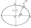
Spherical coordinate system (redirect from Spherical coordinates)
three-dimensional space by using a distance and two angles as its three coordinates. These are the radial distance r along the line connecting the point...
43 KB (6,355 words) - 20:55, 14 April 2025
HGRS87 specifies a non-geocentric datum that is tied to the coordinates of the key geodetic station at the Dionysos Satellite Observatory (DSO) northeast...
7 KB (827 words) - 10:33, 27 October 2024
usual Cartesian coordinates, 13 others are tabulated below. Curvilinear coordinates Geodetic coordinates Orthogonal basis Skew coordinates Tensor Vector...
30 KB (3,273 words) - 16:42, 12 July 2025

Planetary coordinate system (redirect from Planetographic coordinates)
twin satellites. Reference ellipsoids are also useful for defining geodetic coordinates and mapping other planetary bodies including planets, their satellites...
20 KB (2,182 words) - 23:08, 6 July 2025
also known as MGRS-New, which is used for WGS84 and some other modern geodetic datums, the letter for the first row – just north of the equator – is A...
17 KB (2,278 words) - 03:52, 28 June 2025

Azimuth (redirect from Geodetic bearing)
theodolite whose axis is perpendicular to the surface of the spheroid; geodetic azimuth (or geodesic azimuth) is the angle between north and the ellipsoidal...
14 KB (1,768 words) - 08:17, 23 June 2025
Spatial reference system (redirect from Cartographic coordinates)
reference framework for measuring geographic coordinates (latitude and longitude). Examples include the World Geodetic System and the 1927 and 1983 North American...
15 KB (1,570 words) - 12:19, 7 May 2025
values of the coordinates only make sense when a coordinate reference system (CRS) is specified. The default CRS is the World Geodetic System 1984 (WGS-84)...
15 KB (1,944 words) - 12:22, 20 May 2025

real world coordinates of those points on the ground, the map is then said to be "in control". Having a base map and other data in geodetic control means...
7 KB (718 words) - 14:11, 14 May 2024

List of the highest major summits of the United States (category Lists of coordinates)
section's coordinates using OpenStreetMap Download coordinates as: KML GPX (all coordinates) GPX (primary coordinates) GPX (secondary coordinates) A total...
166 KB (13,957 words) - 15:59, 1 July 2025

Adjustment of the North American Datum of 1988. It superseded the National Geodetic Vertical Datum of 1929 (NGVD 29), previously known as the Sea Level Datum...
7 KB (730 words) - 01:21, 16 June 2025