Geological mapping of Georgia is the creation of geological maps—special-purpose maps made to show geological features—of the State of Georgia in the United...
31 KB (4,081 words) - 17:06, 1 April 2025

The U.S. state of Georgia is commonly divided into four geologic regions that influence the location of the state's four traditional physiographic regions...
15 KB (1,824 words) - 00:59, 24 May 2025

Kentucky and Georgia, are extensively mapped geologically. Geology portal Cross section (geology) Cartography Digital geological mapping Geology Gravity map...
12 KB (1,563 words) - 19:41, 1 April 2025

oldest city in the U.S. state of Georgia and the county seat of Chatham County. Established in 1733 on the Savannah River, the city of Savannah became the...
113 KB (9,385 words) - 10:14, 27 May 2025

region of the U.S. state of Georgia. As of the 2020 census, the population was 39,973. The county seat is Chatsworth. Murray County is part of the Dalton...
33 KB (2,959 words) - 23:32, 28 March 2025

of the General Assembly of the State of Georgia. Clark & Hines, State Printers. 1907. p. 484. Adam Andrzejewski (August 14, 2018). "Mapping The U.S....
13 KB (541 words) - 23:51, 28 March 2025

Taylor County is a county located in the west central portion of the U.S. state of Georgia. As of the 2020 census, the population was 7,816. The county seat...
16 KB (1,101 words) - 16:53, 26 April 2025
The University of Georgia (UGA or Georgia) is a public land-grant research university with its main campus in Athens, Georgia, United States. Chartered...
225 KB (23,811 words) - 21:26, 13 May 2025

County is in the US state of Georgia. As of the 2020 census the population was 266,620. The county seat is Canton. The county Board of Commissioners is...
39 KB (2,835 words) - 22:50, 17 May 2025

part of the U.S. state of Georgia. As of the 2020 United States census, the population was 2,848, making it the fourth-least populous county in Georgia. The...
21 KB (1,588 words) - 14:37, 17 May 2025

Evans County is a county in the southeastern portion of the U.S. state of Georgia. As of the 2020 census, the population was 10,774. The county seat is...
55 KB (4,478 words) - 23:59, 20 February 2025

ACF River Basin (category Landforms of Georgia (U.S. state))
Retrieved February 14, 2007. "Georgia Soil and Water Conservation Commission Interactive Mapping Experience". Georgia Soil and Water Conservation Commission...
20 KB (594 words) - 16:53, 13 April 2025
State of Alabama and Part of Georgia – Coalfields and Producing Districts (Map). Scale 1:1,000,000. Washington D.C. U.S. Geological Survey. 1919 "BGS Report...
18 KB (1,538 words) - 17:30, 24 May 2025
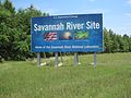
Savannah River Site (category Economy of Augusta, Georgia)
the Savannah River Plant, is a U.S. Department of Energy (DOE) reservation in the United States, located in the state of South Carolina on land in Aiken...
182 KB (20,575 words) - 19:23, 27 May 2025

Point Roberts, Washington (category Peninsulas of Washington (state))
ship of Vancouver's expedition. The two parties made contact and agreed to share information and work together in mapping the Strait of Georgia. Point...
49 KB (4,838 words) - 05:36, 21 May 2025
a rural area east of the city of Chattanooga, and it is near Ooltewah, Collegedale, and north Georgia to the south. It is part of the Chattanooga, TN–GA...
8 KB (361 words) - 19:47, 3 January 2025
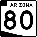
were once part of U.S. Route 80, which traveled through Arizona between San Diego, California and Savannah, Georgia, starting in 1926. The US 80 designation...
15 KB (1,571 words) - 01:32, 25 March 2025

The geography of Evans County describes a county in the state of Georgia in the Southeastern United States in North America. According to the 2010 census...
13 KB (1,184 words) - 19:15, 27 May 2025

the St. Marys River into Georgia north of Boulogne and south of Folkston. US 1 was designated through Florida when the U.S. Numbered Highway System was...
108 KB (6,465 words) - 05:04, 2 April 2025
Robert D. Hatcher (category Presidents of the Geological Society of America)
Viele, G. W. (1990). The U. S. Appalachian and Ouachita Orogens. The geology of North America, volume F-2. Geological Society of America. ISBN 0813752094...
23 KB (2,645 words) - 16:23, 23 May 2025
Oregon (redirect from Oregon (U.S. state))
is a state in the Pacific Northwest region of the United States. It is a part of the Western U.S., with the Columbia River delineating much of Oregon's...
196 KB (16,660 words) - 14:24, 26 May 2025

portion of the U.S. state of Georgia. As of the 2020 census, the population was 156,010. The legal county seat is Appling, but the de facto seat of county...
37 KB (3,619 words) - 22:44, 20 May 2025

National Geospatial-Intelligence Agency (redirect from U.S. Defense Mapping Agency)
climate change. The eighth and current director of the agency is Vice Admiral Frank D. Whitworth III. U.S. mapping and charting efforts remained relatively unchanged...
52 KB (4,448 words) - 05:29, 19 May 2025
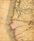
continents of Africa, Asia, Europe, South America, or the Pacific. In 1846, Tanner published A New Universal Atlas. Geologic map of Georgia Tanner, Henry...
4 KB (501 words) - 00:39, 16 October 2024

Colorado River (redirect from Geological history of the Colorado River)
System. U.S. Geological Survey. 2023. Retrieved August 11, 2024. "Colorado River". Geographic Names Information System. United States Geological Survey...
246 KB (23,468 words) - 02:46, 27 May 2025

Information System. United States Geological Survey, United States Department of the Interior. Retrieved 19 April 2012. U.S. Geological Survey Geographic Names...
74 KB (7,511 words) - 11:32, 19 April 2025

New Jersey (redirect from New Jersey (U.S. state))
New Jersey is the fifth-smallest state in land area. As of the 2024 U.S. census estimate, it had a population of 9.5 million, its highest ever and the...
282 KB (23,860 words) - 03:07, 21 May 2025

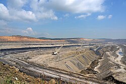
Gold mining in the United States (section Georgia)
Principal Gold-Producing Districts of the United States, U.S. Geological Survey, Professional Paper 610, p.231. US Geological Survey: Carolina Slate Belt Gold...
37 KB (4,626 words) - 02:48, 5 February 2025

United States Census Bureau (redirect from U. S. Census Office)
U.S. Census Bureau is part of the U.S. Department of Commerce and its director is appointed by the president of the United States. Currently, Ron S....
50 KB (4,496 words) - 22:08, 29 May 2025

detailed, large-scale mapping: the U.S. Geological Survey and U.S. Coast and Geodetic Survey (now the National Geodetic Survey, a part of the National Oceanic...
143 KB (17,675 words) - 14:00, 3 May 2025