
The Global Area Reference System (GARS) is a standardized geospatial reference system developed by the National Geospatial-Intelligence Agency (NGA) for...
3 KB (470 words) - 12:54, 13 December 2022
scheme. There are other geographic naming systems of this alphanumeric kind: Global Area Reference System (GARS) has been adopted by the National...
15 KB (2,136 words) - 19:17, 1 June 2025

developed for global military operations, replaced by the current Global Area Reference System (GARS). Open Location Code or "Plus Codes", developed by Google...
23 KB (2,540 words) - 22:18, 14 May 2025
of 17,000 feet over GJPJ3716. List of geodesic-geocoding systems Global Area Reference System (GARS) Maximum elevation figure correlated to each GEOREF...
7 KB (897 words) - 13:26, 4 November 2024
A spatial reference system (SRS) or coordinate reference system (CRS) is a framework used to precisely measure locations on the surface of Earth as coordinates...
15 KB (1,570 words) - 12:19, 7 May 2025
Wide Area Augmentation System (WAAS) is an air navigation aid developed by the Federal Aviation Administration to augment the Global Positioning System (GPS)...
42 KB (4,012 words) - 16:26, 17 March 2025

Geodetic datum (redirect from Geodetic reference system)
geodetic system (also: geodetic reference datum, geodetic reference system, or geodetic reference frame, or terrestrial reference frame) is a global datum...
32 KB (3,377 words) - 03:19, 15 May 2025
The Global Positioning System (GPS) is a satellite-based hyperbolic navigation system owned by the United States Space Force and operated by Mission Delta...
184 KB (19,110 words) - 08:39, 20 June 2025
the database management systems developed by the Oracle Corporation, the System Global Area (SGA) forms the part of the system memory (RAM) shared by all...
4 KB (415 words) - 04:23, 21 July 2018

Satellite navigation (redirect from Global Navigation Satellite System)
satnav system is a system that uses satellites to provide autonomous geopositioning. A satellite navigation system with global coverage is termed global navigation...
45 KB (4,560 words) - 11:19, 28 May 2025
Address geocoding (category Geographic information systems)
World Geographic Reference System (GEOREF), developed for global military operations, replaced by the current Global Area Reference System (GARS). Open Location...
29 KB (3,771 words) - 10:07, 24 May 2025
The Irish grid reference system is a system of geographic grid references used for paper mapping in Ireland (both Northern Ireland and the Republic of...
7 KB (754 words) - 22:01, 25 March 2025

Linear referencing, also called linear reference system or linear referencing system (LRS), is a method of spatial referencing over linear or curvilinear...
10 KB (1,210 words) - 21:32, 23 February 2025

coordinate system – also called a projected coordinate reference system, planar coordinate system, or grid reference system – is a type of spatial reference system...
21 KB (2,805 words) - 00:44, 11 June 2025
Force systems agreed remarkably well for the NAD, ED and TD areas, they were consolidated and became WGS 60. Improvements to the global system included...
24 KB (2,842 words) - 03:41, 26 April 2025
The global language system is the "ingenious pattern of connections between language groups". Dutch sociologist Abram de Swaan developed this theory in...
29 KB (3,905 words) - 20:18, 14 June 2025

Differential GPS (redirect from Differential Global Positioning System)
Differential Global Positioning Systems (DGPSs) supplement and enhance the positional data available from global navigation satellite systems (GNSSs). A...
26 KB (2,943 words) - 22:01, 14 April 2025
equal area cells that both partition the entire Earth at multiple levels of granularity and provide a global spatial reference frame. The system must also...
43 KB (3,199 words) - 03:26, 5 May 2025

GSM (redirect from Global system for mobile communications)
The Global System for Mobile Communications (GSM) is a family of standards to describe the protocols for second-generation (2G) digital cellular networks...
40 KB (4,609 words) - 01:32, 19 June 2025
approximate the geoid, or modeling a region with a best-fit reference ellipsoid. For surveys of small areas, a planar (flat) model of Earth's surface suffices...
25 KB (2,946 words) - 21:41, 7 May 2025

Real-time kinematic positioning (redirect from Virtual reference station)
providing up to centimetre-level accuracy (see DGPS). With reference to GPS in particular, the system is commonly referred to as carrier-phase enhancement,...
12 KB (1,344 words) - 00:31, 11 June 2025

GSM-R (redirect from Global System for Mobile Communication – Railway)
GSM-R, Global System for Mobile Communications – Railway or GSM-Railway is an international wireless communications standard for railway communication...
41 KB (3,958 words) - 16:58, 23 April 2025
The Global Climate Observing System (GCOS) was established in 1992 as an outcome of the Second World Climate Conference, to ensure that the observations...
18 KB (1,912 words) - 02:15, 8 June 2025
Ordnance Survey National Grid (redirect from British national grid reference system)
Survey National Grid reference system (OSGB), also known as British National Grid (BNG), is a system of geographic grid references, distinct from latitude...
19 KB (2,175 words) - 10:16, 2 May 2025

Vertical datum (redirect from Vertical reference system)
horizontal datum, such as NOAA's planned gravimetric and Global Navigation Satellite Systems (GNSS)-based Datum of 2022 set to be released that year by...
11 KB (1,529 words) - 10:36, 3 February 2025
The Global Earth Observation System of Systems (GEOSS) was built by the Group on Earth Observations (GEO) on the basis of a 10-Year Implementation Plan...
20 KB (1,984 words) - 23:29, 17 September 2024

Mercator/Universal Polar Stereographic (UTM/UPS) coordinate system, which is a global (or universal) system of grid-based maps. The transverse Mercator projection...
18 KB (2,858 words) - 13:14, 29 May 2025
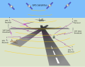
The local-area augmentation system (LAAS) is an all-weather aircraft landing system based on real-time differential correction of the GPS signal. Local...
12 KB (1,416 words) - 16:11, 17 March 2025

Geoid (redirect from Reference geoid)
exerts greater gravitational force than the surrounding areas. The geoid in turn serves as a reference coordinate surface for various vertical coordinates...
29 KB (3,445 words) - 01:09, 2 June 2025

The error analysis for the Global Positioning System is important for understanding how GPS works, and for knowing what magnitude of error should be expected...
37 KB (5,054 words) - 16:12, 15 June 2025