being a shaded hachure map; an example of such a map is the Dufour Map of Switzerland. Emil von Sydow designed maps with coloured hachures: green for lowlands...
6 KB (676 words) - 18:43, 7 October 2023

Publications in 1980. This showed the relief by using hachures. Library of Congress, Geography and Maps: General Collections Archived 16 September 2017 at...
20 KB (2,043 words) - 19:20, 2 May 2024
Terrain cartography (redirect from Relief-Shaded Elevation Map)
profiles. Some viewers are able to see the effect more easily than others. Hachures, first standardized by the Austrian topographer Johann Georg Lehmann in...
25 KB (2,863 words) - 17:47, 7 May 2024

Contour line (redirect from Contour map)
Schiehallion experiment. In 1791, a map of France by J. L. Dupain-Triel used contour lines at 20-metre intervals, hachures, spot-heights and a vertical section...
36 KB (4,352 words) - 20:55, 31 May 2024

of methods to visualise the bottom topography. Early methods included hachure maps, and were generally based on the cartographer's personal interpretation...
27 KB (3,768 words) - 14:06, 25 May 2024

Switzerland is mostly hilly or mountainous) is depicted on the Dufour Map with hachures, which makes it appear especially vivid. Relief and elevation differences...
4 KB (509 words) - 15:56, 21 March 2021

Cartographic design (redirect from Map design)
years and are difficult to replicate digitally, such hill profiles and hachures; others, such as shaded relief and contour lines, are much easier to produce...
45 KB (6,030 words) - 20:59, 21 May 2024

elevations in the two-dimensional top view of a map. Zuzanna Skiba conceptually transfers the terrain hachure to natural and emotional energies, which appear...
8 KB (983 words) - 11:10, 5 June 2023
History of cartography (redirect from Ancient map)
consequences of cartography, or mapmaking technology, throughout human history. Maps have been one of the most important human inventions for millennia, allowing...
142 KB (17,588 words) - 09:23, 29 May 2024
sections based on Lohrmann's divisions. The relief is portrayed using hachure shading, with lines indicating slope. Schmidt makes no attempt to portray...
20 KB (1,923 words) - 03:41, 15 November 2023
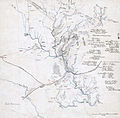
the first to depict elevation by hachuring and the only maps to use regional Native American placenames. Nicollet's Map of the Hydrographical Basin of the...
16 KB (1,708 words) - 16:48, 20 March 2024

Detailed map of Mount Rainier's summit and northeast slope showing upper perimeter of Osceola collapse amphitheater (hachured line)...
7 KB (890 words) - 06:03, 27 January 2024
water color. Col. Map 244 × 121 cm. ([Peter Force map collection]). Scale 1:126,720; 2 English miles to an inch. Relief shown by hachures. Shows campsites...
8 KB (999 words) - 12:45, 15 April 2024
same character with relief in the style of the great classic atlases (hachuring), in contrast to newly published works, that used isohypses (contour lines)...
2 KB (267 words) - 21:27, 2 June 2024
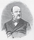
1847 was governor of Berlin. He was also the inventor of a system of hachuring for maps. Failing health compelled his retirement in the latter year, and he...
13 KB (1,264 words) - 17:14, 2 February 2024

272–278. Symonds, pp. 41–43; Sears, pp. 103–106; Esposito, text for Map 94 (Map 34b in the online version); Eicher, pp. 504–507; McPherson, p. 649. Sears...
130 KB (16,824 words) - 22:05, 2 June 2024
of Aghabullogue. A ringfort was depicted on 1842 and 1904 OS 6-inch maps as hachured circular enclosure (diam. c. 40m), truncated on the northeast side...
4 KB (239 words) - 23:20, 26 May 2023

Pennsylvania and Maryland from Gettysburg to the Potomac River. Shows relief by hachures along the line, creeks, roads, cities and towns. Chartered on January 9...
12 KB (931 words) - 11:38, 30 October 2023

"The Transformation of Relief Representation on Topographic Maps in Hungary: From Hachures to Contour Lines". The Cartographic Journal. 55 (2): 150–158...
4 KB (413 words) - 20:14, 28 May 2024

August Heinrich Petermann (category Map publishing companies)
Petermann as the first cartographer who used a terrain map as basis for population maps. By using hachuring as a basis for his Karte des Österreichischen Kaiserstaates...
86 KB (11,978 words) - 15:02, 3 June 2024

Society, 1976. Title on case: A map: the hydrographical basin of the Mississippi River, 1843. Relief shown by hachures. "Reduced and compiled under the...
30 KB (3,910 words) - 14:06, 31 March 2024

Emil von Sydow (category Map publishing companies)
soon followed by maps of other continents. On these maps, Sydow developed a color methodology for landscape features using hachures, where green was depicted...
3 KB (365 words) - 17:42, 12 August 2023

Retrieved 10 September 2020. Eritrea and Ethiopia (Map). 1:5,000,000. Central Intelligence Agency. 2009. Map #803395. Archived from the original on 22 October...
97 KB (9,773 words) - 08:19, 4 June 2024
refashioning with passing time or increasing distance. hachure Any of a series of non-numerical lines used on a map to indicate the general orientation and steepness...
261 KB (26,722 words) - 03:48, 1 June 2024

are shaded; craters are shown by hachures. Northwest-southeast trend of the furrows on the western side of the map area is radial to the Imbrium Basin...
5 KB (676 words) - 21:08, 27 April 2024
Hachures extend the range to the north and northwest, but the implication is that the name Ocooch applied only to its southernmost end. An 1833 map,...
7 KB (849 words) - 14:10, 18 May 2024

the bulk material by process known as fatigue. The crankshaft also shows hachures, which are the lines on fracture surfaces that can be traced back to the...
10 KB (1,274 words) - 03:43, 28 October 2023
29; land case map A-1272 (Bancroft Library).Shows drainage, boundaries, adjoining ranchos, etc.Relief shown pictorially and by hachures. Creator/Contributor:...
5 KB (657 words) - 14:26, 11 May 2023

General Map of a Survey in California: In Connection with Examinations for Railroad Routes to the Pacific Ocean. 1855. Relief shown by hachures. "Proof...
15 KB (2,138 words) - 01:07, 28 November 2023

publication not identified]: [publisher not identified], 1884. Relief shown by hachures. Oriented with north toward the upper right. "Title derived from warrants...
23 KB (2,721 words) - 21:35, 27 July 2023