
parameters are required for the horizontal position to avoid this. The most common horizontal position representation is latitude and longitude. The parameters...
8 KB (756 words) - 05:26, 11 August 2024

the traditional method of latitude and longitude, it is a horizontal position representation, which means it ignores altitude and treats the earth surface...
18 KB (2,858 words) - 13:14, 29 May 2025

coordinate system Coordinate system Horizon Horizontal angle Horizontal coordinate system Horizontal position representation Local tangent plane Northing and easting...
17 KB (2,140 words) - 20:39, 30 May 2025
market. As of early 2015, high-quality Standard Positioning Service (SPS) GPS receivers provided horizontal accuracy of better than 3.5 meters (11 ft), although...
184 KB (19,110 words) - 08:39, 20 June 2025

Geographic coordinate system (redirect from Geo Position)
model of the shape of the earth (usually a reference ellipsoid for a horizontal datum, and a more precise geoid for a vertical datum) to the earth. Traditionally...
23 KB (2,540 words) - 22:18, 14 May 2025
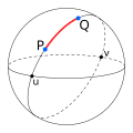
N-vector (category Geographic position)
longitude) for horizontal position representation in mathematical calculations and computer algorithms. Geometrically, the n-vector for a given position on an...
9 KB (1,209 words) - 11:35, 10 June 2025

Geodetic datum (redirect from Horizontal datum)
information systems, remote sensing, and cartography. A horizontal datum is used to measure a horizontal position, across the Earth's surface, in latitude and longitude...
32 KB (3,377 words) - 03:19, 15 May 2025

two positions are on either side of this meridian. To avoid these complexities, some applications use another horizontal position representation. The...
38 KB (4,438 words) - 04:02, 11 June 2025
World Geodetic System (category Global Positioning System)
Heritage surveying methods found elevation differences from a local horizontal determined by the spirit level, plumb line, or an equivalent device that...
24 KB (2,842 words) - 03:41, 26 April 2025
(Macmillan, New York, 1913). Gade, Kenneth (2010). "A Non-singular Horizontal Position Representation". Journal of Navigation. 63 (3): 395–417. Bibcode:2010JNav...
20 KB (2,836 words) - 23:39, 27 May 2025

Earth-centered, Earth-fixed coordinate system (redirect from Geocentric position)
actual locations on the Earth. The ECEF that is used for the Global Positioning System (GPS) is the geocentric WGS 84, which currently includes its own...
9 KB (912 words) - 16:39, 14 December 2024
raster location representation, data fusion, and spatial databases. The most usual grids are for horizontal position representation, using a standard...
43 KB (3,199 words) - 03:26, 5 May 2025
32767, along with a standard machine-readable well-known text (WKT) representation. The dataset is maintained by the IOGP Geomatics Committee. Most geographic...
5 KB (444 words) - 20:42, 28 January 2025
respectively, and are separated by a comma. They are coordinates of a horizontal grid (2D). If a third comma-separated value is present, it represents...
15 KB (1,944 words) - 12:22, 20 May 2025

circumference) Geodetic coordinates Geodetic datum Geodesic Horizontal position representation Latitude / Longitude Map projection Reference ellipsoid Satellite...
6 KB (638 words) - 18:54, 22 June 2025
planimetric map is one that does not include relief data. Horizontal position representation Two-dimensional space Hart, David A. (July 1, 1998). "Planimetric...
2 KB (238 words) - 17:09, 1 June 2024
Geodesy is the scientific discipline that deals with the measurement and representation of the earth, its gravitational field and geodynamic phenomena (polar...
7 KB (1,078 words) - 12:07, 24 August 2024
ratio". Posidonius calculated the Earth's circumference by reference to the position of the star Canopus. As explained by Cleomedes, Posidonius observed Canopus...
21 KB (2,443 words) - 15:24, 12 June 2025
Wide Area Augmentation System (category Global Positioning System)
developed by the Federal Aviation Administration to augment the Global Positioning System (GPS), with the goal of improving its accuracy, integrity, and...
42 KB (4,012 words) - 16:26, 17 March 2025
Retrieved 2008-07-21. Gade, Kenneth (2010). "A non-singular horizontal position representation" (PDF). The Journal of Navigation. 63 (3). Cambridge University...
13 KB (1,920 words) - 08:30, 23 January 2025

Coordinate system Horizontal position Line element Parametric surface Position fixing Position four-vector Six degrees of freedom Vertical position The term displacement...
9 KB (1,215 words) - 04:50, 27 February 2025
Transverse Mercator WGS 84 Zone 16N") comprises a choice of Earth ellipsoid, horizontal datum, map projection (except in the geographic coordinate system), origin...
15 KB (1,570 words) - 12:19, 7 May 2025

general)[citation needed] Gade, Kenneth (2010). "A non-singular horizontal position representation" (PDF). The Journal of Navigation. 63 (3). Cambridge University...
75 KB (10,633 words) - 15:56, 30 April 2025
circumference) Geodetic coordinates Geodetic datum Geodesic Horizontal position representation Latitude / Longitude Map projection Reference ellipsoid Satellite...
25 KB (2,946 words) - 21:41, 7 May 2025

The North American Datum (NAD) is the horizontal datum now used to define the geodetic network in North America. A datum is a formal description of the...
13 KB (1,648 words) - 16:38, 2 June 2025

Geocodes Geodetic datum Geographical distance Graticule (cartography) Horizontal plane Lattice graph (grid as mathematical abstraction) Map projection...
21 KB (2,805 words) - 00:44, 11 June 2025
grid zone. (Latitude band X is the exception to this rule.) Therefore, a position reported in a modern datum usually cannot be misunderstood as using an...
15 KB (2,136 words) - 19:17, 1 June 2025
First horizontal position coordinate (Φ or y), such as latitude (negative number south of equator and positive north of equator) Second horizontal coordinate...
9 KB (1,100 words) - 11:36, 6 February 2025
preparation of marine charts, and failed to include the broader concept of positioning or measurements in all marine environments. The use of different data...
17 KB (1,712 words) - 19:18, 14 April 2025

Geodesy (redirect from Geodetic positioning)
points. One purpose of point positioning is the provision of known points for mapping measurements, also known as (horizontal and vertical) control. There...
38 KB (4,261 words) - 12:17, 21 June 2025