giving the public road access to Kaikōura again. The highway runs inland on the Inland Kaikōura Road from SH 1 just south of Kaikōura. It then turns south...
7 KB (439 words) - 23:12, 21 April 2024

around the Kaikōura Peninsula and in the 1870s roads and bridges were built. A small wharf was completed in 1863. The Inland Kaikōura Road to Rotherham...
78 KB (7,040 words) - 07:44, 9 June 2024

the Inland Kaikōura Road and the Main North Line railway effectively cut off all land routes into Kaikōura. At the morning of 19 November, Kaikōura remained...
75 KB (6,734 words) - 00:25, 8 June 2024

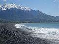
from the Seaward Kaikōura Range, reaching the Pacific Ocean at the tiny settlement of Peketā, 7 kilometres (4 mi) southwest of Kaikōura. Kāti Māmoe had...
6 KB (537 words) - 08:56, 16 May 2024
Zealand. It is 146 kilometres by road north of Christchurch on the Inland Kaikōura Road (SH70) between Culverden and Kaikōura. The resort is a 40-minute drive...
4 KB (572 words) - 06:47, 13 April 2024

Conway River (New Zealand) (category Kaikōura District)
south end of the Seaward Kaikōura Mountains before turning north-east and reaching the Pacific Ocean 30 kilometres south of Kaikōura. The Charwell River is...
2 KB (150 words) - 01:46, 13 April 2024
the district, aside from Kaikōura township, include: The Kaikōura District Council (Māori: Ko te kaunihera ā rohe o Kaikōura) administers the district...
16 KB (1,316 words) - 04:39, 2 June 2024

Zealand's South Island. It is between Culverden and Waiau on the Inland Kaikōura Road, on the northernmost part of the Amuri Plain. It lies near the south...
7 KB (664 words) - 03:27, 10 August 2023
The Kaikōura Canyon is a geologically active submarine canyon located southwest of the Kaikōura Peninsula off the northeastern coast of the South Island...
18 KB (2,257 words) - 22:29, 7 November 2023
List of major junctions on New Zealand State Highway 1 (category Lists of roads in New Zealand)
concurrency ends Seddon 50 31 Awatere River Kaikoura District Kowhai 163 101 Alpine Pacific Triangle (Inland Kaikōura Road) – Mt Lyford Village, Hanmer Springs...
31 KB (34 words) - 10:47, 10 April 2024

After the 2016 Kaikōura earthquake closed State Highway 1 along the Kaikōura Coast, the idea was mooted to upgrade Rainbow Road as an inland state highway...
5 KB (470 words) - 00:06, 5 August 2023

State Highway 1 (New Zealand) (redirect from Far North Road)
and Hapuku Rivers north of Kaikōura was closed from 14 November 2016 to 15 December 2017, due to damage from the 2016 Kaikōura earthquake. SH 1 passes through...
54 KB (5,368 words) - 10:51, 10 April 2024

Station is a high country cattle station. It is located behind the Inland Kaikōura Mountain range in the South Island's Marlborough District. It is New...
8 KB (787 words) - 19:43, 13 June 2024

Ngāi Tahu (redirect from Te Rūnanga o Kaikōura)
Canterbury: Te Rūnanga o Kaikōura centres on Takahanga and extends from Te Parinui o Whiti to the Hurunui River and inland to the Southern Alps / Kā...
72 KB (8,300 words) - 04:07, 3 June 2024

State Highway 7 (New Zealand) (category Infobox road instances in New Zealand)
of New Zealand state highways List of roads and highways, for notable or famous roads worldwide "One Network Road Classification: South Island State Highways"...
5 KB (409 words) - 04:40, 8 September 2023

Hutton's shearwater (category Kaikōura District)
birds that crash-land at night on streets in Kaikōura, and the establishment of a protected area on the Kaikōura Peninsula including a predator-proof fence...
19 KB (1,821 words) - 12:24, 14 February 2024
List of highways numbered 70 (redirect from State Road 70)
Gukjido 70 Inland Kaikoura Road Norwegian National Road 70 N70 highway (Philippines) Autovía A-70 Autovía CV-70 R70 road (South Africa) A70 road Interstate...
6 KB (443 words) - 23:07, 4 April 2024
North Island. A tsunami, caused by the Kaikōura earthquake, of 2.5 m (8 ft) was said to have been recorded at Kaikōura. An investigation revealed that the...
48 KB (5,563 words) - 10:12, 17 May 2024

route of the Inland Pack Track follows an old farm road to Bullock Creek. The Bullock Creek road is a 6 kilometres (3.7 mi) long gravel road that provides...
13 KB (1,244 words) - 01:54, 17 June 2024

envisaged to then follow a series of inland valleys (such as those of the Conway and Charwell Rivers) to Kaikōura. The outbreak of World War I led to a...
24 KB (2,653 words) - 16:19, 27 September 2023

area was Nathanael Chalmers, who was guided inland by Chiefs Reko and Kaikōura in 1853. Reko and Kaikōura showed Chalmers the rock bridge Whatatorere...
11 KB (1,199 words) - 23:20, 7 May 2024
Hokitika Rural Waitaha Whataroa-Harihari Hokitika Valley-Otira Kaikōura Ranges Kaikōura Hanmer Range Amuri Hanmer Springs Upper Hurunui Parnassus Ashley...
62 KB (4,617 words) - 19:47, 1 June 2024

township located at the southern end of the lake of the same name in the inland South Island of New Zealand. It had 558 residents according to the 2018...
26 KB (2,347 words) - 01:12, 20 May 2024

Waiau is the largest town on State Highway 70, also known as the Inland Kaikōura Route. From 1919 until 1978, Waiau was the terminus of the Waiau Branch...
13 KB (1,073 words) - 23:21, 19 May 2024

community in the Americas and the third worldwide, after Bali in Indonesia and Kaikōura in New Zealand, to receive this prestigious award because of its development...
14 KB (1,923 words) - 14:31, 9 January 2024
New Zealand state highway network (category Roads in New Zealand)
Hanmer Springs, Kaikōura and Waipara. Inland Scenic Route – formerly SH 72, this road goes from Amberley to Winchester (near Timaru). This road follows around...
23 KB (2,353 words) - 04:31, 27 March 2024

South Island (section Road transport)
highest peak, Aoraki / Mount Cook at 3,724 metres (12,218 ft). The high Kaikōura Ranges lie to the northeast. The east side of the island is home to the...
104 KB (9,395 words) - 19:40, 12 June 2024

Fault, it runs northeast through a straight valley to the west of the Inland Kaikōura mountains. This valley is parallel with that of the Waiau Toa / Clarence...
9 KB (810 words) - 10:46, 10 April 2024
models. The $450 million was earmarked for repairs following the 2016 Kaikōura earthquake and for further locomotive and rolling stock purchases. As part...
51 KB (4,277 words) - 03:46, 17 May 2024

south), one around the rocky coast, and one inland (part of a longer cycleway) parallel to the railway. The inland route is pre-European – it was traditionally...
17 KB (1,866 words) - 11:47, 11 June 2024