The South Fork Eel River, a river in the northern part of the U.S. state of California, rises near Laytonville and flows about 105 miles (169 km) in a...
10 KB (326 words) - 06:11, 5 July 2023

rivers in California Rivers of Lake County, California Benbow State Recreation Area Eel River Athapaskans List of South Fork Eel River crossings "Eel...
71 KB (8,372 words) - 03:45, 2 May 2024
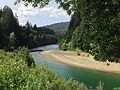
The South Fork Eel River is the largest tributary of the Eel River in north-central California in the United States. The river flows 105 miles (169 km)...
29 KB (3,585 words) - 03:13, 13 May 2023
Beach, South Carolina. It rises in two main tributaries (North Fork & South Fork) from springs under the Sandhills region of West Central South Carolina...
9 KB (734 words) - 03:03, 15 May 2024
Register of Historic Places in Alabama List of crossings of the Tennessee River Waterways forming and crossings of the Gulf Intracoastal Waterway Brotherhood...
101 KB (9,295 words) - 01:17, 16 May 2024

The North Fork Eel River is the smallest of four major tributaries of the Eel River in northwestern California in the United States. It drains a rugged...
8 KB (623 words) - 04:31, 27 December 2022

South Yuba River State Park is located along the South Fork of the Yuba River in the Sierra Nevada, within Nevada County, in Northern California. The...
4 KB (299 words) - 20:17, 24 December 2023
S. Route 101, to join the East Fork Russian River just below Lake Mendocino. From there the Russian River flows south, past Ukiah through the Ukiah Valley...
29 KB (3,015 words) - 19:19, 15 May 2024

90 List of cities and towns along the Potomac River List of crossings of the Potomac River List of islands on the Potomac River List of rivers of Maryland...
89 KB (6,051 words) - 20:23, 19 May 2024

Little Wabash River (Illinois) Vermilion River (Illinois and Indiana) Eel River (Indiana) Little River (Indiana) left tributaries White River (Indiana) Mississinewa...
27 KB (3,210 words) - 15:59, 5 April 2024

Rice Fork is a 22.7-mile-long (36.5 km) tributary of the Eel River in Lake County, California. The Rice Fork begins on the upper northwest side of Goat...
15 KB (2,108 words) - 18:15, 21 June 2023

and the Big River, on the east by the South Fork Eel River, and on the north by Ten Mile River, named for its distance from the Noyo River. The average...
12 KB (1,163 words) - 00:04, 6 January 2023
(North Fork Tye River source)) at Tye River Gap and flows 8.7 miles (14.0 km) east, then southeast, to its confluence with the South Fork. The South Fork also...
12 KB (1,513 words) - 23:21, 28 June 2022

and Burlington County. Near The Forks, where it receives the Batsto River, the Mullica broadens into a navigable river approximately 20 miles (32 km) long...
7 KB (737 words) - 23:24, 12 January 2024

Vincennes Bridge Company (category Construction and civil engineering companies of the United States)
Jean River, Ola, Arkansas (Vincennes Bridge company), NRHP-listed Secrest Ferry Bridge, County Road 450 E over the West Fork of the White River, Gosport...
4 KB (433 words) - 10:22, 1 September 2022
Corner Dugas Duguayville Dumfries Dundee Dunlop Durham Bridge E Eel Ground Eel River Cove Elgin Elm Hill Escuminac Esgenoôpetitj Evandale Évangéline F...
22 KB (2,134 words) - 12:37, 2 May 2024

and is neighbored to the south by the Noyo River watershed and to the east and north by the South Fork Eel River watershed. River flow is precipitation-driven...
15 KB (1,606 words) - 02:45, 9 May 2024

stage of this plan would divert water from Northern California's Trinity, Klamath and Eel Rivers to Southern California, allowing more Colorado River water...
257 KB (25,097 words) - 06:50, 9 May 2024

Assessment Study (CEIA) of the complete Avon River Watershed in order to protect the Endangered Atlantic Salmon, the COSWIC listed American Eel and their 'critical...
9 KB (1,030 words) - 14:58, 28 March 2024

Kings Canyon National Park (category Kings River (California))
National Parks. The majority of the 461,901-acre (186,925 ha) park, drained by the Middle and South Forks of the Kings River and many smaller streams, is...
96 KB (10,828 words) - 23:32, 15 April 2024

August Complex fire (category Wikipedia articles in need of updating from December 2020)
into the Six Rivers National Forest, jumping the canyons of the Mad River and North Fork Eel River, before crossing the Eel River south of Alderpoint....
67 KB (5,263 words) - 01:54, 3 April 2024

Sacramento River, McCloud River and Pit River. The Upper Sacramento begins near Mount Shasta, at the confluence of North, Middle and South Forks in the Trinity...
123 KB (12,490 words) - 13:14, 13 May 2024

means "where there are forks". Both Lehigh County and Lehigh Valley are named for the river. Between 1821 and 1966, the Lehigh River was owned by the Lehigh...
12 KB (940 words) - 05:05, 26 December 2023

Moyie River Canyon Bridge—464' Transport portal Engineering portal United States portal List of highest bridges List of longest bridges List of tallest...
37 KB (1,170 words) - 11:59, 26 March 2024

Asotin Creek (category Rivers of Asotin County, Washington)
receiving Middle Branch and South Fork creeks from the right, before crossing into Asotin County. The 14.9-mile (24.0 km) long South Fork starts near Wickiup...
23 KB (2,660 words) - 12:56, 21 March 2024

The Murray River (in South Australia: River Murray) (Ngarrindjeri: Millewa, Yorta Yorta: Dhungala (Tongala)) is a river in Southeastern Australia. It is...
50 KB (4,746 words) - 03:56, 5 March 2024

Northwestern Pacific Railroad (category Eel River (California))
south entrance of Island Mountain tunnel Milepost 206.5 – bridge over Eel River Milepost 209 – Alderpoint Milepost 237.7 – South Fork bridge over Eel...
71 KB (6,012 words) - 13:00, 17 March 2024

Walker Pass (category Kern River Valley)
the Kern River was named, while accompanying the Frémont expedition of 1845. After 1860 it became a mining freight route to Owens Valley. List of Sierra...
7 KB (615 words) - 08:42, 4 February 2024
Fork Owyhee River Middle Fork Owyhee River South Fork Owyhee River Little Owyhee River Shoshone County City of Shoshone Shoshone John Peak Shoshone Falls...
108 KB (8,688 words) - 12:39, 8 May 2024

U.S. Route 101 in California (redirect from South Valley Freeway)
to follow the South Fork Eel River and Eel River all the way to Fortuna near the mouth of the river. About 12 miles (19 km) northwest of Laytonville, US 101...
147 KB (7,210 words) - 06:04, 12 May 2024