
State Route 103 (SR 103) is a 16.3-mile (26.2 km) long state highway in extreme southern Maine. The route is signed east–west, but forms a half-loop,...
5 KB (448 words) - 02:13, 1 April 2023
Illinois Route 103 Indiana State Road 103 Iowa Highway 103 (former) K-103 (Kansas highway) Kentucky Route 103 Louisiana Highway 103 Maine State Route 103 Maryland...
6 KB (414 words) - 20:12, 17 April 2024
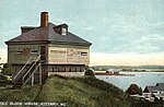
U.S. Route 1, Maine State Route 101, Maine State Route 103, and Maine State Route 236. See also Kittery (CDP), Maine and Kittery Point, Maine for village...
31 KB (2,939 words) - 20:34, 1 May 2024

State routes in Maine are highways within the Maine State Highway System that are signed and maintained by the Maine Department of Transportation, and...
91 KB (221 words) - 11:10, 11 April 2024

State Route 11 (SR 11) is a state highway in the U.S. state of Maine. It is a major interregional route which runs nearly the entire length of the state...
34 KB (1,657 words) - 04:50, 13 October 2023

State Route 100 (SR 100) is a state highway in the U.S. state of Maine, running from Portland to Bangor. The south end of SR 100 is at the intersection...
15 KB (362 words) - 15:48, 21 March 2024
1979. The Bray House is set on the south side of Pepperell Road (Maine State Route 103), on a site overlooking the mouth of the Piscataqua River. It is...
3 KB (342 words) - 15:01, 24 October 2023

historic church complex at 23 Pepperrell Road (Maine State Route 103) in the Kittery Point section of Kittery, Maine. Built in 1730 for a congregation first...
5 KB (589 words) - 00:44, 6 September 2023

State Route 236 (SR 236) is a state highway located in extreme southern Maine, entirely within York County. It begins at State Route 103 in Kittery and...
6 KB (478 words) - 01:11, 8 April 2023

William Pepperrell House (category Houses on the National Register of Historic Places in Maine)
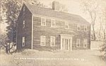
Pepperrell House is a historic house at 94 Pepperrell Road (Maine State Route 103) in Kittery Point, Maine. Built about 1682 and later enlarged and restyled, it...
4 KB (427 words) - 17:33, 30 May 2022

Terrace (southbound), local roads which provide a connection to Maine State Route 103 (SR 103). The remaining stretch of highway ceases to be limited-access...
9 KB (712 words) - 14:11, 18 February 2024

direct route between Portland and Augusta, the state capital, than its parent I-95. It also is toll-free, unlike I-95, which carries the tolled Maine Turnpike...
18 KB (1,171 words) - 09:23, 6 September 2023

State Route 4 (SR 4) is a 168.85-mile (271.74 km) long state highway located in southern and western Maine. It is a major interregional route and the...
32 KB (2,551 words) - 21:09, 26 October 2023

4-inch (10 cm) topping. This was used for the construction of the Maine State Route 103 bridge that crosses the York River. The seven-span 510-foot (160 m)...
15 KB (1,911 words) - 11:12, 2 October 2023

New England road marking system (redirect from New England Multi-state Route 8)
Portland. Route 25 was replaced by U.S. Route 302, most of New Hampshire Route 25, and Maine State Route 25. Route 25A was replaced by Vermont Route 25 and...
158 KB (6,445 words) - 17:10, 1 February 2024

Robert and Louisa Traip House (category Houses on the National Register of Historic Places in Maine)
Traip House is a historic house at 2 Wentworth Street (Maine State Route 103) in Kittery, Maine. Built about 1839, it is a rare statewide example of a...
3 KB (328 words) - 17:31, 30 May 2022

Rice Public Library (category Libraries on the National Register of Historic Places in Maine)
Library is the public library of Kittery, Maine. It is located at 8 Wentworth Street (Maine State Route 103) in the central Kittery Foreside village,...
4 KB (355 words) - 17:59, 22 April 2024

State Route 144 (SR 144) is part of Maine's system of numbered state highways, located in Lincoln County along the state's southern coast. The southern...
7 KB (637 words) - 05:39, 27 September 2023

4-inch (10 cm) topping. This was used for the construction of the Maine State Route 103 bridge that crosses the York River. The seven-span 510-foot (160 m)...
6 KB (698 words) - 06:12, 27 September 2022

U.S. Route 1 (US 1) in the U.S. state of Maine is a major north–south section of the United States Numbered Highway System, serving the eastern part of...
35 KB (1,064 words) - 21:16, 2 December 2023

State Route 148. "Maine DOT Map Viewer". Maine Office of GIS. Retrieved July 8, 2017. KML file (edit • help) Template:Attached KML/Maine State Route 43...
9 KB (286 words) - 02:19, 28 March 2023

State Route 101 (SR 101) is a short state highway in extreme southern Maine. It follows a southeast–northwest trajectory, signed as south–north. SR 101...
4 KB (369 words) - 02:13, 1 April 2023

State Route 3 (SR 3) is a 120.67-mile-long (194.20 km) state highway located in southern Maine. It is a major interregional highway, connecting the Interstate...
13 KB (773 words) - 19:39, 13 May 2024

runs across the state from west to east and is a multi-state route with Vermont and Maine, part of 1920s-era New England Interstate Route 9. The western...
24 KB (1,535 words) - 00:04, 12 May 2024

Route 202 (US 202) is a spur route of US 2. It follows a northeasterly and southwesterly direction stretching from Delaware in the south to Maine in...
57 KB (3,240 words) - 03:48, 13 May 2024

is at the Vermont state line in Charlestown, where it continues west as Vermont Route 11. The eastern terminus is at the Maine state line in Rochester...
24 KB (1,613 words) - 16:42, 20 February 2024

Hampshire Route 25 is a 96.62-mile (155.49 km) long east–west state highway in New Hampshire. It runs completely across the state from Vermont to Maine. The...
22 KB (1,714 words) - 13:19, 28 December 2023

Howells House is located on the south side of Pepperrell Road (Maine State Route 103), occupying a parcel of land that stretches down to the banks of...
3 KB (312 words) - 01:06, 22 May 2024

State Route 102 (SR 102) is a north-south state highway located on Mount Desert Island in eastern Maine. As of 2007, its southern terminus is located...
7 KB (636 words) - 02:13, 1 April 2023

Interstate 95 in New Jersey (redirect from Federal Aid Interstate Route 103)
1942 called the 7-State Highway; this was never built. The New Jersey State Highway Department proposed Federal Aid Interstate Route 103 in 1956, and it...
57 KB (4,017 words) - 20:23, 22 May 2024