
The multi-angle imaging spectroradiometer (MISR) is a scientific instrument on the Terra satellite launched by NASA on 18 December 1999. This device is...
3 KB (362 words) - 14:59, 22 December 2023

Push broom scanner (category Image sensors)
Mars Global Surveyor's Mars Orbiter Camera WAC, and the Multi-angle Imaging SpectroRadiometer on board the Terra satellite. Time delay and integration...
4 KB (432 words) - 16:19, 14 January 2024

Terra (satellite) (section Gallery of images by Terra)
Radiant Energy System) MISR (Multi-angle Imaging SpectroRadiometer) MODIS (Moderate-resolution Imaging Spectroradiometer) MOPITT (Measurements of Pollution...
12 KB (1,035 words) - 19:58, 17 March 2025
Station, one of two main railroad stations in Alexandria Multi-angle Imaging SpectroRadiometer, NASA's remote sensing instrument All pages with titles...
689 bytes (133 words) - 09:13, 26 August 2024

Radiant Energy System) MISR (Multi-angle Imaging Spectroradiometer) MODIS (Moderate Resolution Imaging Spectroradiometer) MOPITT (Measurements of Pollution...
15 KB (1,659 words) - 14:46, 19 July 2025

Measuring severe air pollution in New Delhi in 2016 using the Multi-angle Imaging SpectroRadiometer (MISR) instrument aboard NASA's Terra satellite...
41 KB (3,923 words) - 15:24, 17 July 2025

of height. An example of the stereo technique using the Multi-angle Imaging SpectroRadiometer (MISR) instrument and using the Along Track Scanning Radiometer...
4 KB (452 words) - 03:17, 16 April 2025

participate as full citizens." In 2017, Tosca's work with the Multi-angle Imaging SpectroRadiometer (MISR) was featured by the NASA Jet Propulsion Laboratory...
17 KB (1,513 words) - 00:36, 18 July 2025

885211. Lloyd, Jonathan (April 24, 2015). "NASA Observatory Sends Back First Images of Earth's Soil Moisture". NBC. Evans, D. L. (2005). "Seasat—A 25-year legacy...
9 KB (924 words) - 04:31, 27 May 2025

Cloud (section Multi-level or moderate vertical)
foreground probably cumulonimbus. Particles in the atmosphere and the sun's angle enhance colors of stratocumulus cumulogenitus at evening twilight. Tropospheric...
124 KB (12,948 words) - 17:00, 27 July 2025
through her doctoral research. Thereafter I worked on the multi-angle imaging spectroradiometer (MISR) satellite project and at the Environmental Technology...
5 KB (458 words) - 15:46, 30 March 2024
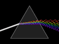
Dispersion (optics) (section In imaging)
spectrometers and spectroradiometers. However, in lenses, dispersion causes chromatic aberration, an undesired effect that may degrade images in microscopes...
33 KB (3,427 words) - 15:59, 19 June 2025

measurements by other EOS instruments such as the Moderate Resolution Imaging Spectroradiometer (MODIS). Results from the CERES and other NASA missions, such...
20 KB (2,116 words) - 21:06, 14 April 2025

wavelengths, 750 km swath, resolution 75 km and 0.15 K Istok 1 IR spectroradiometer - wavelengths between 4.0-16.0 micrometer, 7 km swath, 0.7 x 2.8 km...
7 KB (675 words) - 09:47, 26 October 2024

manufacturers may have been produced using 10 nm increments or more on their spectroradiometer. The result is what would seem to be a smoother ("fuller spectrum")...
32 KB (3,611 words) - 02:59, 9 July 2025

Remote sensing in geology (section Image processing)
instrument in use is called spectroradiometer in lab and imaging spectrometer or multi-/ hyper-spectral scanner as imaging remote sensors. Provided that...
63 KB (7,134 words) - 14:51, 8 June 2025
Lens for SLR Cameras of the Dynax/Maxxum Series". Konica Minolta Photo Imaging, Inc. 2005-07-15. Retrieved 2015-07-09. "Konica Minolta AF 35 mm F1.4G...
28 KB (5,506 words) - 04:56, 1 March 2025

produces images of a particular location on the Earth twice a day. AVHRR and more recently the moderate-resolution imaging spectroradiometer (MODIS) are...
103 KB (13,395 words) - 03:40, 19 July 2025
from shipborne, island-based, and satellite (moderate-resolution imaging spectroradiometer) observations". Journal of Geophysical Research: Atmospheres....
34 KB (3,013 words) - 05:10, 17 July 2025

Moderate-Resolution Imaging Spectroradiometer (MODIS) on NASA's Aqua and Terra satellites captured this event in this series of photo-like images. In May 2021...
23 KB (5,399 words) - 18:03, 9 June 2025