
Route 62, also known as Liam Hickey Drive, is an access road which connects the Trans-Canada Highway at an interchange with the town of Holyrood. It runs...
3 KB (163 words) - 18:39, 18 May 2025
This is a list of highways in Newfoundland and Labrador. Newfoundland and Labrador is unusual among jurisdictions in Canada in that it exclusively uses...
39 KB (2,795 words) - 03:06, 2 March 2024

The Trans-Labrador Highway (TLH) is the primary public road in Labrador, the mainland portion of the province of Newfoundland and Labrador, Canada. The...
25 KB (1,536 words) - 11:01, 17 February 2025
Route 1 is a highway in the Canada province of Newfoundland and Labrador, and is the easternmost stretch of the Trans-Canada Highway. Route 1 is the primary...
32 KB (1,175 words) - 00:58, 24 December 2024
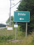
local service district and designated place in the Canadian province of Newfoundland and Labrador on the island of Newfoundland. It is located on the southeastern...
12 KB (1,054 words) - 22:18, 27 February 2025
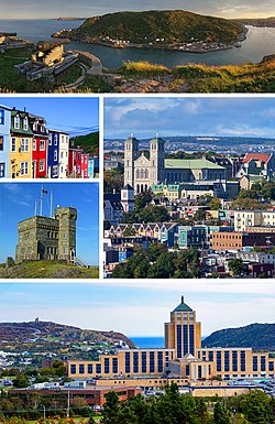
St. John's is the capital and largest city of the Canadian province of Newfoundland and Labrador. It is located on the eastern tip of the Avalon Peninsula...
160 KB (13,404 words) - 22:49, 30 May 2025
Labrador City is a town in western Labrador (part of the Canadian province of Newfoundland and Labrador), near the Quebec border. With a population of...
22 KB (1,077 words) - 23:33, 29 April 2025

Newfoundland and Labrador. It leads from Sheppardville, at Route 1 (Trans-Canada Highway), to a dead end in Fleur de Lys, Newfoundland and Labrador....
5 KB (314 words) - 03:31, 24 May 2025

Route 30 is a 12.0-kilometre-long (7.5 mi) north-south provincial highway in Newfoundland and Labrador, extending from St. John's through Logy Bay-Middle...
3 KB (180 words) - 23:28, 14 February 2024

Labrador (/ˈlæbrədɔːr/) is a geographic and cultural region within the Canadian province of Newfoundland and Labrador. It is the primarily continental...
64 KB (5,852 words) - 02:38, 27 May 2025

Canadian province of Newfoundland and Labrador. The route begins at the intersection of Route 1 (The Trans Canada Highway) in Deer Lake and ends in St. Anthony...
14 KB (825 words) - 18:21, 5 April 2024

northernmost permanent settlement in the Canadian province of Newfoundland and Labrador, within the Nunatsiavut region, located about 370 km (230 mi)...
33 KB (1,965 words) - 17:12, 26 May 2025

Route 20 is a 30.2-kilometre-long (18.8 mi) provincial highway in Newfoundland and Labrador, extending from St. John's to the towns of Torbay, Flatrock...
6 KB (302 words) - 21:23, 31 January 2025

Route 100 (also known as The Cape Shore Highway and Argentia Access Road) is a major highway in Newfoundland and Labrador. The highway begins at its northern...
8 KB (472 words) - 23:31, 14 February 2024

highway on the Avalon Peninsula of Newfoundland. It runs between the town of Cupids and the city of St. John's. Route 60 begins as Topsail Road at the west...
8 KB (342 words) - 06:57, 16 January 2023

from Goobies to Grand Bank, Newfoundland and Labrador. The maximum speed limit is 90 km/h except through communities and settlements where the speed limit...
15 KB (719 words) - 15:08, 22 October 2022
Bell Island is an island that is part of Newfoundland and Labrador, Canada's easternmost province. With an area of 34 square kilometres (13 sq mi), it...
127 KB (15,375 words) - 20:52, 3 March 2025

Route 360, also known as Bay d'Espoir Highway, is a provincial highway in Newfoundland and Labrador. It runs from the Bishop's Falls area to Bay d'Espoir...
7 KB (426 words) - 01:44, 16 July 2024

Cove-St. Philips in Newfoundland and Labrador, Canada. Route 40 also serves as the primary access to St. John's International Airport and the Bell Island...
4 KB (271 words) - 21:09, 30 August 2024

in the Canadian province of Newfoundland and Labrador. It connects the town of Burgeo with the Trans-Canada Highway (Route 1). The highway is a winding...
4 KB (286 words) - 16:35, 18 April 2023

of Newfoundland and Labrador. Its eastern terminus is the intersection at the Trans-Canada Highway (Route 1) in the Town of Badger, and the route ends...
4 KB (312 words) - 01:44, 16 July 2024

Newfoundland in the Canadian province of Newfoundland and Labrador. It begins at a junction of Route 430 in Wiltondale and terminates at Trout River. It serves...
4 KB (244 words) - 18:21, 5 April 2024
island of Newfoundland in the Canadian province of Newfoundland and Labrador, approximately 40 km (25 mi) south of Gander Bay, 100 km (62 mi) south of...
36 KB (2,690 words) - 20:28, 9 May 2025

Route 75, also known as Veterans Memorial Highway, is a two-lane expressway on the Avalon Peninsula of Newfoundland. The route begins at a trumpet interchange...
7 KB (386 words) - 01:44, 16 July 2024

Route 470, also known as La Poile Highway, is a highway on the West Coast of the Canadian province of Newfoundland and Labrador. It is the last provincial...
5 KB (368 words) - 01:44, 16 July 2024
Party of Newfoundland and Labrador is a provincial political party in Newfoundland and Labrador, Canada. The party was founded in 1949 and most recently...
100 KB (9,709 words) - 00:44, 2 May 2025

Twillingate (redirect from Twillingate, Newfoundland and Labrador)
island of Newfoundland in the province of Newfoundland and Labrador, Canada. The town is about 100 kilometres (62 mi) north of Lewisporte and Gander. Incorporated...
26 KB (2,560 words) - 04:23, 3 October 2024

kind in the entire province of Newfoundland and Labrador. Route 520 begins at an intersection with Route 500 (Trans Labrador Highway) at the western edge...
4 KB (225 words) - 23:55, 10 May 2023
Route 413 is a highway on the Baie Verte Peninsula of Newfoundland in the Canadian province of Newfoundland and Labrador. It is a short route, running...
3 KB (142 words) - 01:45, 16 July 2024
Canadian province of Newfoundland and Labrador. St. Anthony serves as a main service centre for northern Newfoundland and southern Labrador. St. Anthony had...
23 KB (1,633 words) - 08:45, 27 May 2025