
Route 75, also known as Veterans Memorial Highway, is a two-lane expressway on the Avalon Peninsula of Newfoundland. The route begins at a trumpet interchange...
7 KB (386 words) - 08:59, 1 July 2025
This is a list of highways in Newfoundland and Labrador. Newfoundland and Labrador is unusual among jurisdictions in Canada in that it exclusively uses...
39 KB (2,795 words) - 03:06, 2 March 2024

The Trans-Labrador Highway (TLH) is the primary public road in Labrador, the mainland portion of the province of Newfoundland and Labrador, Canada. The...
25 KB (1,536 words) - 11:01, 17 February 2025
Route 1 is a highway in the Canada province of Newfoundland and Labrador, and is the easternmost stretch of the Trans-Canada Highway. Route 1 is the primary...
32 KB (1,175 words) - 01:00, 1 July 2025

of Newfoundland and Labrador. Its eastern terminus is the intersection at the Trans-Canada Highway (Route 1) in the Town of Badger, and the route ends...
4 KB (312 words) - 01:44, 16 July 2024

Canadian province of Newfoundland and Labrador. The route begins at the intersection of Route 1 (The Trans Canada Highway) in Deer Lake and ends in St. Anthony...
14 KB (825 words) - 12:46, 29 June 2025
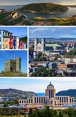
St. John's is the capital and largest city of the Canadian province of Newfoundland and Labrador. It is located on the eastern tip of the Avalon Peninsula...
160 KB (13,416 words) - 20:22, 8 July 2025

Labrador (/ˈlæbrədɔːr/) is a geographic and cultural region within the Canadian province of Newfoundland and Labrador. It is the primarily continental...
64 KB (5,900 words) - 05:11, 6 July 2025
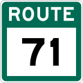
Route 71 (also known as Hodgewater Line) is a highway in the Canadian province of Newfoundland and Labrador. It serves as a bypass road to Route 70 and...
3 KB (118 words) - 08:55, 1 July 2025

in the Canadian province of Newfoundland and Labrador. It connects the town of Burgeo with the Trans-Canada Highway (Route 1). The highway is a winding...
4 KB (286 words) - 16:35, 18 April 2023
in the northeastern part of the island of Newfoundland in the Canadian province of Newfoundland and Labrador, approximately 40 km (25 mi) south of Gander...
36 KB (2,692 words) - 00:04, 22 July 2025

northernmost permanent settlement in the Canadian province of Newfoundland and Labrador, within the Nunatsiavut region, located about 370 km (230 mi)...
34 KB (1,981 words) - 20:40, 19 June 2025

Isle, connecting the province of Newfoundland and Labrador's mainland Labrador region with the island of Newfoundland. This strait has a minimum width...
11 KB (1,179 words) - 14:18, 6 March 2025

Route 30 is a 12.0-kilometre-long (7.5 mi) north-south provincial highway in Newfoundland and Labrador, extending from St. John's through Logy Bay-Middle...
3 KB (180 words) - 23:28, 14 February 2024
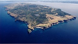
Bell Island is an island that is part of Newfoundland and Labrador, Canada's easternmost province. With an area of 34 square kilometres (13 sq mi), it...
127 KB (15,376 words) - 06:43, 16 July 2025

on the Bonavista Peninsula, Newfoundland in the Canadian province of Newfoundland and Labrador. Unlike many Newfoundland coastal settlements, Bonavista...
21 KB (1,181 words) - 01:38, 4 April 2025
Labrador City is a town in western Labrador (part of the Canadian province of Newfoundland and Labrador), near the Quebec border. With a population of...
22 KB (1,079 words) - 09:05, 22 July 2025
Party of Newfoundland and Labrador is a provincial political party in Newfoundland and Labrador, Canada. The party was founded in 1949 and most recently...
100 KB (9,730 words) - 16:58, 17 July 2025

Route 20 is a 30.2-kilometre-long (18.8 mi) provincial highway in Newfoundland and Labrador, extending from St. John's to the towns of Torbay, Flatrock...
6 KB (302 words) - 21:23, 31 January 2025

Newfoundland and Labrador. It leads from Sheppardville, at Route 1 (Trans-Canada Highway), to a dead end in Fleur de Lys, Newfoundland and Labrador....
5 KB (314 words) - 03:31, 24 May 2025

Newfoundland and Labrador is the easternmost province of Canada, in the country's Atlantic region. The province comprises the island of Newfoundland and...
200 KB (19,039 words) - 16:28, 14 July 2025

Route 73 is a 19.2-kilometre-long (11.9 mi) east–west highway on the Avalon Peninsula of Newfoundland. It connects the towns of New Harbour and Spaniard's...
3 KB (137 words) - 01:44, 16 July 2024

Conception Harbour (redirect from Avondale North, Newfoundland and Labrador)
Peninsula in Newfoundland and Labrador, Canada. It is in Division 1 on Conception Bay and can be accessed via Newfoundland and Labrador Route 60. Conception...
9 KB (677 words) - 00:58, 1 July 2025
Burgeo (redirect from Back Cove, Burgeo, Newfoundland and Labrador)
Canadian province of Newfoundland and Labrador. It is located mainly on Grandy Island, on the south coast of the island of Newfoundland. It is an outport...
16 KB (811 words) - 00:55, 14 July 2025
Canadian province of Newfoundland and Labrador. St. Anthony serves as a main service centre for northern Newfoundland and southern Labrador. St. Anthony had...
23 KB (1,651 words) - 15:36, 24 June 2025

the Avalon Peninsula of Newfoundland. The highway also carries the designation of Baccalieu Trail for its entire length. Route 70 begins in Roaches Line...
9 KB (348 words) - 01:43, 16 July 2024

province of Newfoundland and Labrador. The road provides a direct link from the Trans-Canada Highway (TCH) to downtown St. John's, Newfoundland, which was...
10 KB (653 words) - 22:11, 30 August 2024

province of Newfoundland and Labrador. It straddles the line between the provinces two largest cities, the capital city of St. John's and the city Mount...
7 KB (610 words) - 21:57, 8 March 2025

part of the island of Newfoundland in the province of Newfoundland and Labrador, Canada. The town derives its name from Deer Lake and is situated at the...
14 KB (885 words) - 16:30, 16 July 2025

Route 239 is a highway in the Trinity Bight portion of Newfoundland in the Canadian province of Newfoundland and Labrador. It is a short route, running...
3 KB (216 words) - 15:16, 22 October 2022