
Nippletop is a mountain in the Colvin Range of the Adirondack Mountains in New York. With an elevation of 4,620 feet (1,410 m), it is the 13th-highest...
4 KB (402 words) - 17:44, 1 February 2025

Nippletop is a 6,715-foot (2,047-meter) elevation white Navajo Sandstone summit located in Zion National Park, in Washington County of southwest Utah...
4 KB (210 words) - 06:43, 6 April 2025

Lake, nicknamed the Capital of the Adirondacks. View of Mount Colvin and Nippletop from the ascent to Gothics. "Adirondack". Merriam-Webster.com Dictionary...
28 KB (3,036 words) - 00:42, 30 April 2025

Isanaklesh Peaks, in Maricopa County, Arizona, formerly known as Squaw Tits. Nippletop, in the Adirondack High Peaks of New York. During the later 19th century...
32 KB (3,077 words) - 15:59, 17 May 2025
Survey, United States Department of the Interior. Retrieved May 28, 2024. "Nippletop". Geographic Names Information System. United States Geological Survey...
22 KB (2,069 words) - 11:32, 13 May 2025
Mountain 1,425 4,675 Alaska, US Giant Mountain 1,410.3 4,627 New York, US Nippletop 1,408.2 4,620 New York, US Pikui 1,408 4,619 Ukraine – Highest point in...
141 KB (176 words) - 16:49, 11 May 2025

Whiteface Eastern Adirondacks Giant Rocky Peak Colvin Range Blake Colvin Dial Nippletop Dix Range Dix Grace Peak South Dix Hough Macomb Northern High Peaks Big...
5 KB (404 words) - 19:22, 1 February 2025
Mountain, Mount Skylight, Mount Marcy, Mount Haystack, Mount Colvin, Nippletop Mountain, Dial Mountain, Lower Wolfjaw Mountain, Upper Wolfjaw Mountain...
9 KB (890 words) - 06:14, 15 March 2025
Peak 4840 9 Basin 4827 10 Gothics 4736 11 Colden 4714 12 Giant 4627 13 Nippletop 4620 14 Santanoni 4607 15 Redfield 4606 16 Wright Peak 4580 17 Saddleback...
10 KB (944 words) - 17:14, 12 November 2024

part of the Colvin Range. Dial Mountain is flanked to the southwest by Nippletop. Dial Mountain stands within the watershed of Lake Champlain, which drains...
4 KB (238 words) - 04:42, 2 February 2025
Whiteface Eastern Adirondacks Giant Rocky Peak Colvin Range Blake Colvin Dial Nippletop Dix Range Dix Grace Peak South Dix Hough Macomb Northern High Peaks Big...
5 KB (441 words) - 16:11, 1 February 2025
highest summit of the Bear River Mountains Navajo Mountain Nelson Peak Nippletop Northgate Peaks North Guardian Angel Notch Mountain Observation Point...
143 KB (11,355 words) - 23:47, 29 March 2025

Gothics, Saddleback, Basin, Tabletop, Marcy, Haystack, Redfield, Allen, Nippletop, Dial and Blake.[citation needed] The mountain is named after Verplanck...
4 KB (250 words) - 04:40, 2 February 2025

0.9 mi (1.4 km) east-northeast of Ant Hill, 1.5 mi (2.4 km) north of Nippletop, and 1.9 mi (3.1 km) northwest of Checkerboard Mesa. Precipitation runoff...
4 KB (267 words) - 14:40, 4 May 2025

Mount Jo Mount McGregor Mount Morris Mount Pisgah Mount Van Hoevenberg Nippletop Noonmark Mountain Ohmer Mountain Owls Head Mountain Palmer Hill Panther...
6 KB (580 words) - 22:29, 24 March 2025

source of water for resident bighorn sheep. Other nearby peaks include Nippletop to the west and Ant Hill to the northwest. Precipitation runoff from this...
4 KB (305 words) - 10:23, 5 January 2025

to such mountain tops as Round Top Mountain, Noonmark, Bear Den, Dial, Nippletop, Colvin, Blake and Pinnacle. The steep, rugged terrain, characteristic...
7 KB (774 words) - 09:25, 13 May 2025

Giant, Lower Wolfjaw, Upper Wolfjaw, Armstrong, Gothics, Saddleback, Basin, Nippletop and Dix, Hough, Marcy, Gray, Skylight, and Colden (foreground)...
12 KB (996 words) - 23:36, 31 January 2025
Mount Jo Mount McGregor Mount Morris Mount Pisgah Mount Van Hoevenberg Nippletop Noonmark Mountain Ohmer Mountain Owls Head Mountain Palmer Hill Panther...
5 KB (474 words) - 20:40, 23 January 2024

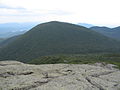
Dix Range Dix Mountain and Hough Peak seen from Nippletop. Highest point Peak Dix Mountain Elevation 4,855 ft (1,480 m) Coordinates 44°4′56″N 73°47′11″W...
4 KB (261 words) - 18:45, 1 February 2025

and features. As seen from Hough Peak Dix Mt. and Hough Peak seen from Nippletop View from Dix Mountain Peak on July 1, 2018, looking towards Elk Lake...
9 KB (892 words) - 16:21, 1 February 2025

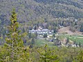
miles, Lazy Street, which provides access to the creek. At the base of Nippletop Mountain, Blue Ridge Road passes along the north shore of Palmer Pond...
10 KB (998 words) - 04:41, 2 May 2025