
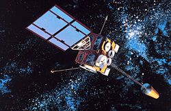
The Operational Land Imager (OLI) is a remote sensing instrument aboard Landsat 8, built by Ball Aerospace & Technologies. Landsat 8 is the successor...
6 KB (608 words) - 18:24, 17 May 2024

Landsat 8 (section Operational Land Imager)
conduct on-going mission operations. It comprises the camera of the Operational Land Imager (OLI) and the Thermal Infrared Sensor (TIRS), which can be used...
23 KB (2,268 words) - 14:50, 25 May 2025

Landsat program (redirect from Land remote-sensing satellite)
Mapper Plus (ETM+) scanner. Landsat 8 uses two instruments, the Operational Land Imager (OLI) for optical bands and the Thermal Infrared Sensor (TIRS)...
41 KB (3,817 words) - 03:28, 19 June 2025

Witwatersrand Earth Impact Database Deep Impact – The Vredefort Dome Satellite image of Vredefort impact structure from Google Maps Impact Cratering: an overview...
18 KB (2,022 words) - 18:55, 17 June 2025

former will include near-identical copies of remote sensors: the Operational Land Imager (OLI) and the Thermal Infrared Sensor (TIRS) instruments – optical...
10 KB (855 words) - 11:17, 11 June 2025

Earth Observing-1 (redirect from Advanced Land Imager)
California. Its Advanced Land Imager (ALI) measured nine different wavelengths simultaneously, instead of the seven measured by the imager in Landsat 7. This...
11 KB (946 words) - 00:48, 4 May 2025
Cyclone Oli OLI-model or Eclectic Paradigm, a theory in economics Operational Land Imager, instrument on Landsat Operation Lifesaver, a railroad safety program...
908 bytes (136 words) - 21:41, 16 June 2025
Jagersfontein (category Pages using multiple image with auto scaled images)
deepest hand-excavated hole in the world. For the duration of the mine's operational history, it was run by De Beers up to 1972, when it was deproclaimed...
12 KB (710 words) - 22:41, 16 June 2024

responsible for climate change. By 24 March 230 accommodation centers remained operational, housing 184,282 people. The WFP also provided 7-day rations of food...
125 KB (10,219 words) - 21:18, 1 July 2025

Virgin Islands, Royal Marines had cleared the airfield so that it was operational for the delivery of aid into the islands, with more than 200 British...
219 KB (19,612 words) - 15:01, 23 June 2025

Jagersfontein Mine (category Pages using multiple image with auto scaled images)
with the De Beers corporation. For the duration of the mine's remaining operational history, it was run by De Beers up to 1972, when it was deproclaimed...
14 KB (1,389 words) - 16:12, 25 January 2024
2022 Jagersfontein dam collapse (category Pages using multiple image with auto scaled images)
carat (127.4 g) Reitz Diamond of 1895. For the duration of the mine's operational history, it was run by De Beers up to 1972, when it was deproclaimed...
13 KB (766 words) - 22:49, 15 March 2025

images showed "browning" of Barbuda and other Caribbean islands that had been hit by the storm. The images, captured by the Operational Land Imager (OLI)...
85 KB (7,907 words) - 14:21, 1 June 2025

Ocean color (category Pages using multiple image with auto scaled images)
Suomi-NPP (SNPP) and NOAA-20 (JPSS1) satellites Operational Land Imager (OLI) on Landsat-8 Hyperspectral Imager for the Coastal Ocean (HICO) on the International...
41 KB (4,288 words) - 23:39, 25 May 2025
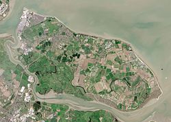
rest of Sheppey is low-lying and the southern part of the island is marshy land criss-crossed by inlets and drains, largely used for grazing. The economy...
40 KB (4,404 words) - 10:10, 3 July 2025

Castle Gorge Magaliesberg mountain range, seen from space with the Operational Land Imager on Landsat 8, 27 June 2018 Highest point Elevation 1,852 m (6,076 ft)...
15 KB (1,651 words) - 13:08, 3 June 2025

eruption of Mauna Loa Mauna Loa's eruption was captured by the Operational Land Imager-2 (OLI-2) on December 2. Volcano Mauna Loa Start date November...
39 KB (3,254 words) - 11:02, 8 February 2025

but rising sea levels may make it necessary briefly to flood some of that land at spring tides, to take the pressure off the defences and main watercourses...
30 KB (2,658 words) - 12:27, 18 March 2025
carried out by the primary payload instruments, which are the Imager and the Sounder. The Imager is a multichannel instrument that senses infrared radiant...
40 KB (4,222 words) - 15:35, 10 June 2025

2013. Netburn, Deborah (19 December 2013). "Is Niijima here to stay? New image of the newest island on Earth". Los Angeles Times. Retrieved 20 December...
47 KB (4,776 words) - 17:52, 28 June 2025

Site in 2018. "Barberton, Mpumalanga". Latitude. "The Barberton Mountain Land, Barberton Greenstone Belt or Makhonjwa Mountains". UNESCO. Retrieved 10...
8 KB (614 words) - 07:56, 5 April 2025
usually lasts 21 weeks. On January 31, 2024, the Operational Land Imager captured this false-color image of a fire burning near Pringle Bay and Betty's...
7 KB (819 words) - 10:37, 4 April 2025

2021 European floods (category Pages using multiple image with auto scaled images)
highlight the need for integrating such high-resolution forecasts into operational flood early warning systems to improve disaster preparedness and response...
81 KB (7,151 words) - 20:30, 21 May 2025
Earth Observing System (category Pages using multiple image with auto scaled images)
| NASA's Earth Observing System". NASA EOS. Masek, G (2022). "Operational Land Imager | Landsat Science | A joint NASA/USGS Earth Observation Program"...
29 KB (2,019 words) - 00:35, 20 June 2025

GOES-16 (redirect from Advanced Baseline Imager)
wavelengths using its Advanced Baseline Imager (ABI). GOES-16's Geostationary Lightning Mapper (GLM) is the first operational lightning mapper flown in geostationary...
82 KB (7,681 words) - 15:31, 27 June 2025

sufficiently to allow NASA to capture a natural colour image of the iceberg using the Operational Land Imager aboard Landsat 8. The calving of A-74 may affect...
7 KB (971 words) - 10:46, 27 October 2023

Solar power in California (section Operational)
In 2014, the 550 MW Topaz Solar Farm became the new "world's largest operational" solar facility and went online in San Luis Obispo County, California...
67 KB (6,172 words) - 17:55, 30 May 2025
Laboratory, Washington D.C. "Special Sensor Microwave/Imager (SSM/I) and Special Sensor Microwave Imager Sounder (SSMIS) Global Gridded Products". National...
9 KB (1,042 words) - 23:21, 6 August 2023
Geostationary Ocean Color Imager (GOCI, /ɡɔːθi/), is the world's first geostationary orbit satellite image sensor in order to observe or monitor an ocean-color...
5 KB (325 words) - 14:57, 22 December 2023
that combines an electro-optical camera, wide area imager, short wave infrared hyperspectral imager, and a high-resolution camera for use as an inspection...
27 KB (2,290 words) - 17:32, 19 May 2025