
Renier Point (62°36′34″S 59°48′21″W / 62.60944°S 59.80583°W / -62.60944; -59.80583) is a narrow point forming the east extremity of both Burgas Peninsula...
4 KB (269 words) - 04:46, 18 December 2023
Look up Renier or renier in Wiktionary, the free dictionary. Renier or Rénier may refer to: Given name: Renier Botha (born 1992), South African rugby union...
2 KB (367 words) - 17:55, 24 May 2024
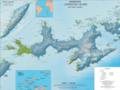
Heights, Edinburgh Hill and Inott Point. The island extends 73 km (45 mi) from Start Point in the west to Renier Point in the east, its width varying from...
74 KB (7,603 words) - 16:35, 1 April 2024

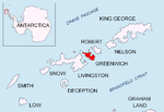
and between 430 and 900 km (230 and 485 nmi) southwest of the nearest point of the South Orkney Islands. By the Antarctic Treaty of 1959, the islands'...
28 KB (2,812 words) - 19:05, 19 February 2024
which is 4.56 km west-southwest of Fort Point, 9.47 km northeast of Renier Point, Livingston Island, 3.3 km east by south of Ephraim Bluff and 2.03 km...
2 KB (232 words) - 17:30, 10 January 2020

side of the south entrance to McFarlane Strait, lying just north of Renier Point, Burgas Peninsula on Livingston Island, in the South Shetland Islands...
964 bytes (105 words) - 22:37, 15 June 2023

Paolo Renier (21 November 1710 – 13 February 1789) was a Venetian statesman, the 119th and penultimate Doge of Venice. He was a noted orator, and served...
3 KB (161 words) - 03:36, 29 March 2024
1.93 km east of Yana Point, 9 km south of Edinburgh Hill, 3.51 km southwest of Half Moon Island and 8.65 km west of Renier Point. South Shetland Islands...
3 KB (342 words) - 19:24, 23 December 2023

east-northeast of Botev Point, 2.6 km northeast of Aytos Point, 3.3 km southeast of Great Needle Peak and 13.99 km southwest of Renier Point. British mapping...
2 KB (222 words) - 17:02, 17 March 2023

Tangra Mountains are 32 kilometres (20 mi) long between Barnard Point and Renier Point, 8.5 kilometres (5.3 mi) wide, and are bounded by Moon Bay and Huron...
13 KB (1,181 words) - 10:50, 11 February 2024

Antarctica extending 10 km (6.2 mi) in the east-northeast direction towards Renier Point and 4.7 km (2.9 mi). It is bounded by Bruix Cove, Moon Bay and Mugla...
6 KB (430 words) - 04:50, 18 December 2023
Islands, Antarctica. Situated 2.8 km east-northeast of Rila Point, 5.9 km west of Renier Point, and 1.5 km south of Half Moon Island. The hook is named after...
2 KB (190 words) - 11:51, 28 December 2023

wide which recedes 4 nautical miles (7 km) between Edinburgh Hill and Renier Point, on the east side of Livingston Island, in the South Shetland Islands...
5 KB (333 words) - 03:58, 22 December 2023

Renier Point. The ridge is named in association with its summit Delchev Peak (ca. 940 m). The north slopes of the ridge between Elena Peak and Renier...
5 KB (452 words) - 18:45, 15 September 2023
1.53 km west-southwest of Mesta Peak and 3.32 km west-southwest of Renier Point. The peak surmounts Pautalia Glacier to the south, and Sopot Ice Piedmont...
3 KB (334 words) - 18:10, 15 September 2023

Keating (1854–1859) H. C. Wiley (1859) J. N. Covarrubias (1859–1860) Joseph Renier (1860) James P. Keating (1860–1861) W. C. Price (1861–1867) J. D. Jenkins...
20 KB (2,359 words) - 00:53, 19 May 2024
rise to approximately 200 m, have rocky, ice-free slopes and surmount Renier Point. The peaks are named after Lyulin Mountain in Bulgaria. The peak is located...
2 KB (212 words) - 18:16, 15 September 2023
Paisiy Peak, 960 m northeast of Rodopi Peak, 5.07 km west by south of Renier Point, 1.92 km west of Besapara Hill and 2.01 km west by north of Kaloyan Nunatak...
4 KB (398 words) - 03:54, 4 December 2023

west-northwest of Renier Point, 4.7 km northeast of Rila Point, 7.89 km southeast of Edinburgh Hill, 8.32 km south-southwest of Triangle Point and 10.25 km...
3 KB (311 words) - 09:34, 4 January 2020
Besapara Hill, 1.05 km northeast of Shabla Knoll and 1.86 km southwest of Renier Point. L.L. Ivanov et al. Antarctica: Livingston Island and Greenwich Island...
3 KB (281 words) - 21:17, 28 October 2019
Gabriel Hill, 1.2 km west of Baliza Hill, 6.11 km west-northwest of Renier Point, livingston Island, 4.05 km north by west of Elena Peak, Livingston Island...
3 KB (324 words) - 04:19, 31 December 2023
Peak, 280 m south-southwest of Malyovitsa Crag and 1.29 km southwest of Renier Point (Bulgarian mapping in 2005 and 2009). L.L. Ivanov et al. Antarctica:...
2 KB (214 words) - 14:35, 13 May 2021
and flows northward into Moon Bay between Rila Point to the west and Malyovitsa Crag near Renier Point to the east. The glacier is named after the Bulgarian...
3 KB (245 words) - 02:28, 21 December 2021

age 15, the same year she reached her peak rating. In 2018, she defeated Renier Castellanos Rodriguez, a Spanish International Master (IM) with a FIDE rating...
33 KB (2,932 words) - 03:16, 13 May 2024
Needle Peak (Falsa Aguja), 3.2 km southeast of Rila Point and 7.6 km west-southwest of Renier Point. The cover of the VA album Under Heaven: Vinson Massif...
3 KB (349 words) - 17:53, 15 September 2023

Renier Meganck (Brussels, baptised on 14 September 1637 – Vienna, 27 November 1690) was a Flemish painter and printmaker known for his landscapes and still...
8 KB (1,034 words) - 17:39, 2 May 2024

Scotland. The point is located at 62°32′33″S 60°01′01″W / 62.54250°S 60.01694°W / -62.54250; -60.01694 which is 13.15 km northwest of Renier Point, 7.52 km...
2 KB (230 words) - 12:28, 2 May 2023
west by north of Sartorius Point, 7.31 km northeast of Renier Point, Livingston Island and 7.44 km southeast of Triangle Point. British mapping in 1821...
2 KB (225 words) - 08:32, 13 April 2020
east slopes of Elena Peak and the north side of Delchev Ridge towards Renier Point, together with the adjacent portion of Sopot Ice Piedmont are a popular...
4 KB (447 words) - 22:45, 20 February 2024
05 km (1 mi) southwest of Mesta Peak and 2.91 km (2 mi) southwest of Renier Point (Bulgarian mapping in 2005 and 2009 from the Tangra 2004/05 survey)....
3 KB (361 words) - 21:26, 28 October 2019