
The River Irthing is a river in Cumbria, England and a major tributary of the River Eden. The name is recorded as Ard or Arden in early references. For...
7 KB (673 words) - 09:15, 1 July 2022
authorised (MTWA) of 12.5 tonnes. The airport is located on a plain near the River Irthing. The airport has been the location for some prehistoric excavations...
29 KB (2,823 words) - 12:10, 1 June 2024
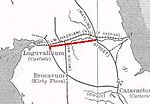
through the natural gap formed by the valleys of the River Tyne in Northumberland and the River Irthing in Cumbria. It predated the Hadrian's Wall frontier...
11 KB (1,386 words) - 16:38, 26 February 2024

Valley between the Pennines and the Lake District, with the vale of the River Irthing above Carlisle. In the north towards Scotland were 8 of its 42 wards...
38 KB (1,136 words) - 12:01, 30 May 2024

King Water (category England river stubs)
portion of the River Irthing and part of the King Water. Hadrian's Wall crossed the King Water to the east of the village of Walton "1891 River Agreement between...
1 KB (102 words) - 12:57, 11 April 2022

railway viaduct of 1834, it merges with the River Irthing from the east, followed by the River Petteril and River Caldew from the south, as it winds through...
7 KB (621 words) - 15:25, 29 April 2024

The River Gelt is a river in Cumbria, England and a tributary of the River Irthing. The source of the Gelt is close to Cumbria's border with Northumberland...
7 KB (730 words) - 03:10, 20 September 2021

Irthing. The Vicus (civil settlement) was immediately south-west of the fort and a cemetery was south-east of the fort near the edge of the Irthing escarpment...
14 KB (1,213 words) - 12:10, 16 February 2024

miles (3.2 km) east of Brampton. It is on the opposite side of the River Irthing to, and just within sight of, Lanercost Priory. It was the seat of the...
9 KB (1,077 words) - 21:49, 4 June 2024

(R) River Petteril (L) River Irthing (R) River Gelt (R) Old Water (R) Cam Beck (R) King Water (R) Gair Burn (Ls) Tarn Beck (Rs) Raven Beck (R) River Eamont...
87 KB (10,761 words) - 18:05, 9 May 2024

the Cheviot Hills, then followed a tributary of the River Irthing and crossed Denton Fell to the River Tees. From Tees Head the boundary crosses the Pennines...
35 KB (2,171 words) - 16:35, 9 May 2024

with a stone wall. This took place in two phases; the first (from the River Irthing to a point west of Milecastle 54), during the reign of Hadrian, and...
70 KB (7,887 words) - 23:11, 26 May 2024

overlooks a bend in the river Irthing; the name is Brythonic, made of cambo- "curved, bent, crooked" and glanna "steep bank, stream/river side, valley with...
7 KB (693 words) - 20:36, 28 January 2024

Ruleholme is a small hamlet on the A689 road and the River Irthing, near the village of Irthington, in the City of Carlisle district, in the English county...
2 KB (171 words) - 03:59, 8 October 2021
population of about 400, most of whom live on the Northumberland side of the River Irthing and Poltross Burn. As in most areas of Britain, Bronze-Age and Iron-Age...
10 KB (1,186 words) - 09:48, 29 January 2024

England. The bridge itself was built in the 19th century and spans the River Irthing. It is a Grade II listed building, listed in 1984. Wikimedia Commons...
1 KB (57 words) - 17:45, 22 August 2021

Poltross Burn (category England river stubs)
Poltross Burn is a tributary of the River Irthing. The burn rises on Denton Fell and flows north-east, joining the Irthing at Gilsland. The well-preserved...
921 bytes (111 words) - 03:34, 20 April 2022

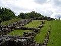
and Wall AD 122 Remains West of the gorge of the River Irthing where the Wall was carried over the river by the bridge at Willowford. The scar or cliff...
158 KB (132 words) - 15:19, 2 May 2023

Cam Beck (category Rivers of Cumbria)
10.9 miles (17.6 km) past Kirkambeck and Cambeck Hill and into the River Irthing. From the British cambaco meaning "crooked stream". "Cam Beck". Catchment...
2 KB (47 words) - 18:45, 29 March 2024

roundabout, with the B6264. From here, the A689 heads east, and crosses the River Irthing at Ruleholme, then it meets the A69 at a roundabout junction. The A689...
5 KB (500 words) - 16:45, 3 September 2022
is about 2 miles (3 km) north of Brampton, on the north bank of the River Irthing. Nearby villages include Newtown, Banks and Lanercost. Walton remains...
12 KB (1,223 words) - 16:39, 12 December 2022
across the River Wear Crossings of the River Severn Category:Crossings of the River Tees Category:Crossings of the River Tyne Crossings of the River Thames...
69 KB (258 words) - 18:28, 2 May 2024
Roman fort and the section of Hadrian's Wall and vallum between the River Irthing and the field boundaries east of milecastle 50 Listed on the National...
12 KB (367 words) - 22:13, 1 December 2023
East) (grid reference NY6296266297) is situated on a river terrace on the south bank of the River Irthing. It was excavated in 1923. It measures approximately...
7 KB (770 words) - 17:26, 17 March 2022

the hamlet extends down to the River Irthing and presumably is the holme (a piece of flat low-lying ground by a river or stream) of Burtholme or Burt's...
4 KB (319 words) - 10:23, 12 February 2022

Hayton parish. Warwick Bridge is located on the River Eden and the A69 road, near the River Irthing. It is five miles east of the city of Carlisle and...
4 KB (351 words) - 17:53, 11 September 2023

part of the system). Historians believe that the Turf Wall from the River Irthing to Bowness-on Solway was rebuilt in stone in two stages. The most easterly...
38 KB (5,587 words) - 00:54, 2 April 2024
shore from Sandsfield almost to Bowness-on-Solway. The valley of the River Irthing, a tributary of the Eden, gives a low-level route via the Tyne Gap to...
67 KB (9,957 words) - 21:05, 19 September 2023

The east and south boundaries of the parish are largely formed by the River Irthing. The area of the parish is 1,838.88 hectares (7.1000 sq mi). Part of...
2 KB (215 words) - 11:08, 12 March 2022
vallum and their associated features between Poltross Burn and the River Irthing in wall mile 48, Upper Denton (1015923)", National Heritage List for...
12 KB (496 words) - 04:49, 20 April 2022