
Rodney Local Board is one of the 21 local boards of Auckland Council, and is administered by the ward councillor representing Rodney Ward. Located in the...
8 KB (526 words) - 08:24, 6 May 2025

Rodney is a local government area in the northernmost part of New Zealand's Auckland Region, governed by the Rodney Local Board and Auckland Council....
3 KB (223 words) - 07:29, 21 July 2024
territorial local authority district Rodney (local board area), a local government area Rodney Local Board, an Auckland Council local board Rodney Ward, an...
1 KB (182 words) - 17:52, 21 February 2024

Rodney District was a local government area in the northernmost part of New Zealand's Auckland Region from 1989 to 2010. It included Kawau Island. It...
4 KB (291 words) - 00:54, 11 April 2025

term as an elected member of the Rodney Local Board as part of the Rodney First ticket – before retiring at the 2019 local body elections to focus on his...
15 KB (1,075 words) - 06:34, 7 April 2025
Coatesville mansion (category Rodney Local Board Area)
Coatesville mansion, originally known as Chrisco mansion, then Dotcom mansion, and lately Mahoenui Valley, is a mansion in Coatesville north of Auckland...
5 KB (351 words) - 06:14, 7 January 2025

Ahuroa (category Rodney Local Board Area)
locality in the north of Auckland, New Zealand. Ahuroa is located in the Rodney Local Board area of the city, within the Warkworth subdivision. Puhoi is to the...
8 KB (767 words) - 20:57, 23 April 2025
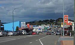
Wellsford (redirect from Rodney College)
with Warkworth in the Rodney Local Board area. Electors in Wellsford vote for the seven-member Rodney Local Board, and also a Rodney ward councillor, who...
24 KB (2,472 words) - 12:13, 20 April 2025
Milldale, New Zealand (category Rodney Local Board Area)
New Zealand City Auckland Local authority Auckland Council Electoral ward Rodney Ward Local board Rodney Local Board Board subdivision Dairy Flat Area...
7 KB (576 words) - 08:01, 17 December 2024

Muriwai (category Rodney Local Board Area)
Muriwai is part of the Local Government Rodney Ward of Auckland Council and is part of the Kumeu Subdivision of the Rodney Local Board. Muriwai is in the...
21 KB (2,028 words) - 20:58, 14 May 2025

of Rodney District; it does not include the Hibiscus Coast, which was also part of Rodney District but is now in Albany ward. The Rodney Local Board area...
12 KB (921 words) - 00:04, 21 February 2025

Kumeū (category Rodney Local Board Area)
Council, Kumeū is a part of the Rodney local government area governed by the Rodney Local Board. It is a part of the Rodney ward, which elects one councillor...
51 KB (5,017 words) - 18:15, 14 May 2025

Pōhuehue (category Rodney Local Board Area)
Pōhuehue is a rural locality in Rodney, in the Auckland Region of New Zealand. It is located on State Highway 1 between Puhoi and Warkworth. Pōhuehue is...
6 KB (431 words) - 04:06, 3 August 2024
Wainui (category Rodney Local Board Area)
Wainui is a locality in the Rodney Ward of the Auckland Region of New Zealand. It is 5 kilometres (3.1 mi) north-east of Waitoki and 10 kilometres (6.2 mi)...
10 KB (1,021 words) - 17:56, 18 January 2025

Kaukapakapa (category Rodney Local Board Area)
commonly known to the locals in its shortened form "Kaukap"; it is sometimes abbreviated to KKK. Kaukapakapa is located in western Rodney at the navigable...
20 KB (2,084 words) - 04:02, 5 May 2025

Riverhead Forest (category Rodney Local Board Area)
the east. To the north and west, the forest is bordered by rural areas of Rodney, including the vineyards of West Auckland. The forest is named after the...
10 KB (690 words) - 17:23, 15 February 2025

Auckland Council (redirect from Local boards of Auckland Council)
November 2016. "Govt papers reveal another Rodney plan". The New Zealand Herald. 28 September 2009. "Rodney Hide: Local boards will engage like never before"...
91 KB (6,413 words) - 06:40, 6 May 2025

Huapai (category Rodney Local Board Area)
Council, Huapai is a part of the Rodney local government area governed by the Rodney Local Board. It is a part of the Rodney ward, which elects one councillor...
16 KB (1,746 words) - 01:45, 27 March 2025

Omaha Cove (category Rodney Local Board Area)
It is located to the north-east of the township of Leigh in the Rodney local board area. The Omaha Cove is adjacent to the township of Leigh, and is...
5 KB (426 words) - 04:20, 12 January 2024

Coatesville, New Zealand (category Rodney Local Board Area)
71639; 174.64250 Country New Zealand Region Auckland Ward Rodney ward Local board Rodney Local Board Subdivision Dairy Flat subdivision Government • Territorial...
8 KB (756 words) - 03:44, 18 April 2025
Mahurangi Peninsula (category Rodney Local Board Area)
Mahurangi Peninsula is a landform in the Rodney Local Board Area in the Auckland Region of New Zealand's North Island. It is located between two bodies...
3 KB (109 words) - 12:18, 3 April 2024
Auckland Surf Park (category Rodney Local Board Area)
Auckland Surf Park is a heated artificial surfing lagoon currently under construction. In 2023, it was decided that the park would be located in Dairy...
7 KB (588 words) - 21:02, 22 March 2025

Waimauku (category Rodney Local Board Area)
Waimauku is part of the Local Government Rodney Ward of Auckland Council and is part of the Kumeu Subdivision of the Rodney Local Board. Waimauku is in the...
13 KB (1,302 words) - 06:02, 18 March 2025

Helensville (category Rodney Local Board Area)
Helensville is a part of the Rodney local government area governed by the Rodney Local Board. It is a part of the Rodney ward, which elects one councillor...
41 KB (4,381 words) - 02:03, 14 December 2024
2023 New Zealand census (section Population counts by territorial authority and Auckland local board areas)
656,486 84,768 5.4 Auckland - Rodney local board area 66,417 77,949 11,532 17.4 Auckland - Hibiscus and Bays local board area 104,010 114,033 10,023 9...
40 KB (2,365 words) - 22:08, 13 February 2025

Parakai (category Rodney Local Board Area)
Parakai is part of the Local Government Rodney Ward of Auckland Council and is part of the Kumeu Subdivision of the Rodney Local Board. It is in the Kaipara...
13 KB (1,306 words) - 20:15, 6 May 2025

Couldrey House (category Rodney Local Board Area)
North Harbour News. 11 May 2001. p. 9. Bioletti, Harry (1992). Rodney Coast to Coast. Rodney District Council. p. 40. ISBN 0-473-01296-0. "Historic sites...
12 KB (1,079 words) - 21:28, 22 March 2025

Te Ārai (category Rodney Local Board Area)
the northern end of the Auckland Region (specifically within the former Rodney District). Mangawhai lies to the north, and Tomarata to the south. The name...
4 KB (269 words) - 21:34, 23 April 2025

Tāwharanui Peninsula (category Rodney Local Board Area)
Tāwharanui Peninsula is a finger of land projecting into the Hauraki Gulf from the east coast of the much larger North Auckland Peninsula of New Zealand...
11 KB (943 words) - 11:05, 18 January 2025

Spectacle Lake (New Zealand) (category Rodney Local Board Area)
Spectacle Lake is a lake at Te Ārai, Rodney in the northern Auckland Region of New Zealand. Spectacle Lake is a sand dune lake located approximately 15 km...
3 KB (162 words) - 08:54, 17 December 2024