Highway 144, commonly referred to as Highway 144, is a provincially maintained highway in the northern portion of the Canadian province of Ontario, linking...
15 KB (1,237 words) - 16:28, 20 June 2024
Highways numbered 144 include: New Brunswick Route 144 Ontario Highway 144 Prince Edward Island Route 144 National Route 144 National Highway 144 (India) Japan...
4 KB (262 words) - 23:32, 4 April 2024

northern section of the Canadian province of Ontario. It begins in the west at an intersection with Highway 144 and the Sultan Industrial Road and proceeds...
9 KB (869 words) - 20:28, 12 May 2021
List of secondary highways in Thunder Bay District (redirect from Ontario Route 527)
in the Canadian province of Ontario, which serves to connect the small community of Hurkett to Highway 17, the main route of the Trans-Canada Highway...
30 KB (1,905 words) - 15:53, 3 September 2023
List of secondary highways in Algoma District (redirect from Ontario Route 546)
populated areas in the Algoma District of northeastern Ontario. Some of the shorter ones are also access routes for communities with moderate amounts of tourism...
35 KB (2,703 words) - 03:04, 20 June 2024
in the Canadian province of Ontario. Comprising a privately leased segment as well as a publicly owned segment, the route spans the entire Greater Toronto...
107 KB (8,333 words) - 08:30, 19 June 2024
List of secondary highways in Sudbury District (redirect from Ontario Route 553)
province of Ontario. It is a highway spur that measures 4.6 kilometres (2.9 mi) in length and connects the town of Gogama with Highway 144. It is the only...
7 KB (491 words) - 20:51, 31 March 2022
most remote regions of Northern Ontario. Major junctions are located with Highway 129 near Chapleau and Highway 144 southwest of Timmins, though the...
20 KB (1,726 words) - 16:34, 15 May 2024

replaced with an intersection with Highway 144 upon the completion of the Northwest Bypass in the mid-1980s. The route of Highway 536 was first assumed by the...
5 KB (497 words) - 16:42, 20 June 2024
List of secondary highways in Kenora District (redirect from Ontario Route 116)
maintained secondary highway in the Canadian province of Ontario. Located in Kenora District, the route branches off Highway 17, the Trans-Canada Highway, between...
30 KB (2,153 words) - 02:37, 7 July 2023
List of secondary highways in Cochrane District (redirect from Ontario Route 572)
connecting Iroquois Falls, Ontario to Highway 11/Trans Canada Highway, and to Highway 101. This provides a very direct route for Timmins-Iroquois Falls...
18 KB (1,354 words) - 10:20, 11 August 2022

Greater Sudbury Municipal Road 35 (category Infobox road instances in Ontario)
Greater Sudbury, Ontario, Canada. Extending from Chelmsford to Downtown Sudbury, most of the road's length is a former alignment of Highway 144, except for...
8 KB (579 words) - 16:30, 20 June 2024
as "Main Street Ontario" and was one of the first roads in what would later become Ontario. It was devised as an overland military route between York (Toronto)...
131 KB (9,529 words) - 22:24, 9 June 2024

the second highway in Ontario to be designated Highway 634, with the original Highway 634 being near Sudbury. The current routing was at first designated...
7 KB (643 words) - 17:05, 20 June 2024
It is also a Core Route in the National Highway System of Canada. The route is maintained by the Ministry of Transportation of Ontario (MTO) and patrolled...
228 KB (16,185 words) - 04:49, 19 June 2024
List of secondary highways in Rainy River District (redirect from Ontario Route 600)
a secondary highway in the Canadian province of Ontario, located in Rainy River District. The route connects Highway 71 (the Trans-Canada Highway) with...
8 KB (525 words) - 15:52, 3 September 2023
List of secondary highways in Timiskaming District (redirect from Ontario Route 558)
province of Ontario. The highway is 7.6 kilometres (4.7 mi) in length, connecting Highway 112 in Dane with the now abandoned Adams Mine site. The route was designated...
17 KB (982 words) - 16:49, 10 April 2023

Sudbury District (redirect from Waterfall, Ontario)
boundary of Greater Sudbury. The Ontario government is converting Highway 69 to a freeway. Virtually the entire route of Highway 69 within the Sudbury...
12 KB (958 words) - 22:03, 7 May 2024
provincially maintained highway and the primary route of the Trans-Canada Highway through the Canadian province of Ontario. It begins at the Manitoba boundary, 50 km...
89 KB (6,792 words) - 16:28, 20 June 2024
List of secondary highways in Manitoulin District (redirect from Ontario Route 540)
the isolated and sparsely populated areas in the Manitoulin District of Ontario. Secondary Highway 540, commonly referred to as Highway 540, is the primary...
11 KB (764 words) - 00:18, 19 June 2024
Thousand Islands Parkway (redirect from Ontario Route 2S)
river road would be the ideal route through the rough terrain between Gananoque and Brockville. On April 29, 1937, The Ontario Department of Highways (DHO)...
26 KB (2,326 words) - 00:53, 22 April 2024
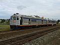
Sudbury–White River train (redirect from Esher station (Ontario))
operated by Via Rail serving communities between Sudbury and White River, Ontario three times a week. The timetable numbers for this train are 185 for the...
5 KB (344 words) - 20:42, 23 December 2023
List of secondary highways in Parry Sound District (redirect from Ontario Route 559)
maintained secondary highway in the Canadian province of Ontario. It is a short and lightly travelled route that connects Highway 69 with the community of Britt...
25 KB (1,585 words) - 21:30, 1 September 2022

University of Western Ontario at the University of Windsor opened in 2008. In 2013, the university completed construction of a $112 million (~$144 million in 2023)...
129 KB (10,080 words) - 08:39, 24 June 2024
Trans-Canada Highway (TCH), the Georgian Bay Route, and is part of the highest-capacity route from southern Ontario to the Canadian West, via a connection with...
81 KB (6,028 words) - 16:17, 24 June 2024

Sudbury District of the Canadian province of Ontario. Roughly 35 kilometres (22 mi) in length, the route connects Highway 129 to the town of Sultan and...
4 KB (317 words) - 16:57, 28 June 2021
Queen Elizabeth Way (redirect from Ontario Route QEW)
in Ontario, the QEW is directionally signed using locations along the route as opposed to cardinal directions. Driving towards Toronto, the route is signed...
95 KB (9,270 words) - 22:14, 19 June 2024
List of numbered roads in Brant County (redirect from Ontario Route 54)
of numbered roads in the County of Brant, in the Canadian province of Ontario. There are two classes of numbered roads in Brant County: county highways...
11 KB (52 words) - 17:00, 15 May 2024
was designated as the Chapleau Route of the Trans-Canada Highway. Highway 129 is one of the most isolated in Ontario and among the least used of the...
15 KB (1,173 words) - 11:05, 20 August 2022
the southwestern portion of the Canadian province of Ontario. The 91.4-kilometre (56.8 mi) route links Chatham and Sarnia via Wallaceburg, following close...
41 KB (3,728 words) - 21:06, 16 March 2024