
A satellite navigation or satnav system is a system that uses satellites to provide autonomous geopositioning. A satellite navigation system with global...
45 KB (4,560 words) - 11:19, 28 May 2025
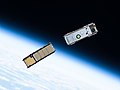
Galileo is a global navigation satellite system (GNSS) created by the European Union through the European Space Agency (ESA) and operated by the European...
104 KB (10,186 words) - 08:22, 4 June 2025

A satellite navigation (satnav) device or GPS device is a device that uses satellites of the Global Positioning System (GPS) or similar global navigation...
39 KB (4,142 words) - 23:23, 17 April 2025

Indian Regional Navigation Satellite System (IRNSS), with an operational name of NavIC (acronym for Navigation with Indian Constellation; also, nāvik 'sailor'...
64 KB (5,319 words) - 14:04, 21 May 2025
BeiDou (redirect from Beidou satellite navigation system)
The BeiDou Navigation Satellite System (BDS; Chinese: 北斗卫星导航系统; pinyin: běidǒu wèixīng dǎoháng xìtǒng) is a satellite-based radio navigation system owned...
68 KB (5,866 words) - 01:18, 2 June 2025
Satellite navigation software or GNSS navigation software a category of software that provide positioning services by utilizing data from satellite navigation...
6 KB (589 words) - 05:06, 25 March 2025
The Global Positioning System (GPS) is a satellite-based hyperbolic navigation system owned by the United States Space Force and operated by Mission Delta...
185 KB (19,119 words) - 09:36, 27 May 2025
GLONASS (redirect from GLObal NAvigation Satellite System)
lit. 'Global Navigation Satellite System') is a Russian satellite navigation system operating as part of a radionavigation-satellite service. It provides...
72 KB (6,243 words) - 04:16, 16 May 2025
Satellite navigation solution for the receiver's position (geopositioning) involves an algorithm. In essence, a GNSS receiver measures the transmitting...
13 KB (1,920 words) - 11:40, 2 January 2025

The field of navigation includes four general categories: land navigation, marine navigation, aeronautic navigation, and space navigation. It is also the...
83 KB (9,370 words) - 14:32, 23 May 2025
the first Soviet satellite navigation system, developed in the former Soviet Union. From 1967 to 1978 a total of 31 Zaliv satellites were launched onboard...
1 KB (105 words) - 21:20, 3 April 2025
European Satellite Navigation Industries, formerly called Galileo Industries until legal action prompted a name change, was a joint venture of the companies...
3 KB (317 words) - 04:22, 2 February 2025

Celestial navigation is performed without using satellite navigation or other similar modern electronic or digital positioning means. Celestial navigation uses...
39 KB (5,086 words) - 03:38, 8 May 2025

Michibiki (みちびき, "guidance"), is a four-satellite regional satellite navigation system and a satellite-based augmentation system developed by the Japanese government...
23 KB (1,908 words) - 01:40, 26 February 2025

GPS satellite blocks are the various production generations of the Global Positioning System (GPS) used for satellite navigation. The first satellite in...
15 KB (1,575 words) - 09:56, 27 May 2025

military satellite is an artificial satellite used for a military purpose. The most common missions are intelligence gathering, navigation and military...
17 KB (1,592 words) - 17:49, 7 January 2025

Differential GPS (redirect from Differential satellite navigation)
supplement and enhance the positional data available from global navigation satellite systems (GNSSs). A DGPS can increase accuracy of positional data...
26 KB (2,943 words) - 22:01, 14 April 2025
The GPS-aided GEO augmented navigation (GAGAN) is an implementation of a regional satellite-based augmentation system (SBAS) by the Government of India...
24 KB (2,667 words) - 03:41, 24 March 2025

NNSS (for Navy Navigation Satellite System), was the first satellite navigation system to be used operationally. The radio navigation system was primarily...
32 KB (3,712 words) - 08:02, 31 May 2025

navigation system is part of the automobile controls or a third party add-on used to find direction in an automobile. It typically uses a satellite navigation...
21 KB (2,335 words) - 22:46, 5 May 2025
This is a list of notable commercial satellite navigation software (also known as GPS software) for various devices, with a specific focus on mobile phones...
16 KB (246 words) - 07:10, 7 May 2025

needed] Satellite navigation systems send several signals that are used to decode the satellite's position, distance between the user satellite, and the...
40 KB (5,315 words) - 22:23, 16 January 2025
remote places. The signal delay from satellites and their orbit's predictability are used in satellite navigation systems, such as GPS. Crewed spacecrafts...
69 KB (6,737 words) - 08:45, 4 June 2025

term used in satellite navigation and geomatics engineering to specify the error propagation as a mathematical effect of navigation satellite geometry on...
16 KB (2,224 words) - 18:22, 1 July 2024

application of surveying to correct for common errors in current satellite navigation (GNSS) systems. It uses measurements of the phase of the signal's...
12 KB (1,344 words) - 08:18, 14 February 2025
Automotive navigation system Marine navigation systems using sonar Satellite navigation system Global Positioning System, a group of satellites and computers...
5 KB (551 words) - 12:16, 9 October 2024
TERCOM (redirect from TERCOM-Aided Inertial Navigation System)
Terrain contour matching, or TERCOM, is a navigation system used primarily by cruise missiles. It uses a contour map of the terrain that is compared with...
12 KB (1,701 words) - 20:43, 17 May 2025

beacons (station-referenced navigation signals), self-contained systems like inertial navigation, and satellite navigation (like GPS). In the United States...
11 KB (1,326 words) - 09:50, 14 February 2025

and navigation (geometric satellite geodesy): 3 Determination of geoid, Earth's gravity field and its temporal variations (dynamical satellite geodesy...
21 KB (2,338 words) - 10:15, 25 November 2024

with curtain airbags. It was also the first European car to offer satellite navigation and the first BMW to offer an in-built television. The E38 was the...
36 KB (3,246 words) - 19:25, 1 June 2025