Shulani (Russian: Шулани; Avar: Щуланиб) is a rural locality (a selo) and the administrative centre of Shulaninsky Selsoviet, Gunibsky District, Republic...
3 KB (102 words) - 22:56, 26 September 2022
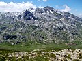
Korab (mountain) (redirect from Shulani i Radomires)
the same ridge are two other peaks rising over 2,700 metres (8,900 ft): Shulani i Radomirës and Korab III. The southeast, stretching from a few rock bands...
10 KB (996 words) - 00:23, 30 April 2024
located 21 km south of Gunib (the district's administrative centre) by road. Shulani and Batsada are the nearest rural localities. Avars live there. Село Унты...
3 KB (90 words) - 22:51, 26 September 2022
southwest of Gunib (the district's administrative centre) by road. Batsada and Shulani are the nearest rural localities. Село Кулла на карте "Всероссийская перепись...
3 KB (99 words) - 10:36, 25 May 2023

Nakazukh Nizhny Keger Obokh Obonub Rosutl Rugudzha Salta Sekh Shangoda Shulani Silta Sogratl Tlogob Tsalada Unkida Unty Urala Rural localities in Karabudakhkentsky...
30 KB (1,518 words) - 16:35, 30 June 2023

937 ft), Korab Gates 2,727 m (8,947 ft), Maja e Moravës 2,718 m (8,917 ft), Shulani i Radomirës 2,716 m (8,911 ft) and Small Korab 2,683 m (8,802 ft). Korab...
26 KB (2,655 words) - 05:01, 13 April 2024
district's administrative centre) by road, on the Batikh River. Batsada and Shulani are the nearest rural localities. Село Наказух на карте Всероссийская перепись...
3 KB (91 words) - 22:39, 26 September 2022
southwest of Gunib (the district's administrative centre) by road. Kulla and Shulani are the nearest rural localities. Село Бацада на карте "Всероссийская перепись...
3 KB (111 words) - 22:25, 26 September 2022