
Springerville (Navajo: Tsé Noodǫ́ǫ́z) is a town in Apache County, Arizona, United States, within the White Mountains. Its postal ZIP Code is 85938. As...
21 KB (1,623 words) - 22:49, 14 May 2025

U.S. Route 180 (redirect from U.S. Route 70 (Holbrook—Springerville, Arizona))
to the town of Springerville, Arizona, where the routes meet U.S. Route 60 the 3 routes begin a triple concurrency through Springerville. On the east side...
16 KB (1,574 words) - 02:21, 30 April 2025

in August 1882. By 1885, each had a 160-acre ranch 10 miles east of Springerville near the New Mexico border. By 1885, the Clanton gang included Lee Renfro...
42 KB (5,131 words) - 16:57, 24 December 2024
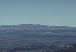
Springerville volcanic field is a monogenetic volcanic field located in east-central Arizona between Springerville and Show Low. The field consists of...
6 KB (483 words) - 23:40, 15 May 2025

with Interstate 10 near Quartzsite to the New Mexico state line near Springerville. As it crosses the state, US 60 overlaps at various points: I-17, I-10...
43 KB (2,570 words) - 20:29, 20 May 2025
Springerville Municipal Airport (FAA LID: JTC, formerly D68 and Q35) is a town-owned public-use airport located 1.15 miles (1.00 nmi; 1.85 km) west of...
4 KB (281 words) - 16:47, 4 May 2025

to St. Johns. From 1880 to 1882, the county seat was temporarily in Springerville, before being returned to St. Johns. An 1896 history of the area described...
38 KB (2,911 words) - 17:13, 15 May 2025
Eagar, Arizona, U.S. Cause of death Gunshot Resting place Springerville Cemetery Springerville, Arizona Other names Bill Cooper Occupation(s) Conspiracy...
27 KB (2,882 words) - 20:34, 30 November 2024

million. The communities of Alpine, Blue River, Greer, Nutrioso, Sunrise, Springerville, Eagar in Arizona, and Luna in New Mexico were evacuated. In addition...
10 KB (767 words) - 02:54, 18 May 2025

archaeological site of the Ancestral Puebloans located near the town of Springerville, Arizona. The site is a nationally recognized archaeological site and...
8 KB (759 words) - 16:29, 1 May 2024

campfire. The communities of Alpine, Blue River, Greer, Nutrioso, Sunrise, Springerville, and Eagar, Arizona, as well as Luna, New Mexico were evacuated. On...
27 KB (2,227 words) - 16:58, 5 May 2025
KQAZ (101.7 FM, "Majik 101.7") is a radio station licensed to serve Springerville, Arizona, United States. The station is owned by William and Mary Ann...
2 KB (117 words) - 18:23, 11 January 2025
Nearby communities include Show Low, Pinetop-Lakeside, Greer, St. Johns, Springerville, Eagar, and McNary. Much of the range is within the Fort Apache Indian...
4 KB (239 words) - 15:46, 17 April 2024

one unit by USDA Forest Service from the Forest Supervisors Office in Springerville, Arizona. Apache–Sitgreaves has over 400 species of wildlife[citation...
13 KB (1,123 words) - 01:04, 8 October 2024

Cenozoic volcanic fields, 800 kilometers (500 mi) long, reaching from the Springerville and White Mountains volcanic fields in East-Central Arizona to the Raton-Clayton...
9 KB (975 words) - 04:57, 3 May 2025

366 (SR 366) and SR 266 to the south of Safford. The route between Springerville and Morenci was designated a National Scenic Byway and given the name...
27 KB (3,055 words) - 02:21, 30 April 2025

for eventually combining the town with other towns such as Amity and Springerville, to unite the small community. However, the US postmaster general rejected...
13 KB (1,039 words) - 00:40, 1 March 2025

February 2020. "SRP: Springerville Generating Station". www.srpnet.com. Retrieved 13 January 2020. "Electricity Data Browser - Springerville". www.eia.gov....
97 KB (2,851 words) - 21:25, 3 May 2025

Mountains) Socorro calderas The Jemez Lineament: San Carlos volcanic field Springerville volcanic field Red Hill volcanic field Zuni-Bandera volcanic field Mount...
21 KB (2,290 words) - 22:24, 20 December 2024
through Globe, Show Low, and Springerville before entering New Mexico. US 60 enters New Mexico in Catron County east of Springerville, Arizona. The road makes...
50 KB (5,486 words) - 16:55, 30 April 2025
Snowflake, and Winslow. Five centers are located in Hopi/Polacca, Kayenta, Springerville, St. Johns, and Whiteriver. NPC also partners with community members...
5 KB (418 words) - 01:03, 26 February 2025

reservoir on the Little Colorado River located 17 miles (27 km) north of Springerville. It is the largest lake in the region. Lyman Lake State Park attracts...
4 KB (346 words) - 21:47, 4 September 2024

Rough Rock KSLX-FM/100.7: Scottsdale KTAN/1420: Sierra Vista KRVZ/1400: Springerville KDUS/1060: Tempe KUCB/1290: Tucson KWRK/96.1: Window Rock WCFL/1000:...
89 KB (7,075 words) - 14:36, 6 May 2025

from New Mexico also began to colonize the region, creating Eagar and Springerville. For many years, Mormons were the primary group living in the watershed...
23 KB (2,448 words) - 00:02, 8 November 2024

Location mi km Destinations Notes 0.00 0.00 US 60 – Springerville, Show Low Southern terminus Concho 19.13 30.79 SR 180A west – Petrified Forest, Holbrook...
4 KB (276 words) - 23:47, 4 March 2025
area was established in 1999 and is approximately seven miles west of Springerville and the nearby town of Eagar. Protected areas of the United States Arizona...
2 KB (70 words) - 18:38, 15 February 2025

There are local ranger district offices in Alpine, Clifton, and Springerville. (Springerville is also the headquarters of the combined Apache–Sitgreaves.)...
4 KB (289 words) - 06:23, 14 February 2025

Phineas Clanton (category People from Springerville, Arizona)
opposite direction. In June 1882 Phin moved 200 miles (320 km) north to Springerville, Apache County, where his sister Mary Elsie lived with her husband Eben...
17 KB (2,094 words) - 14:23, 17 April 2025

along existing county roads to U.S. Route 70 (US 70, now US 60) at Springerville. At the same time, SR 73 was extended southwest from Rice to Cutter...
6 KB (505 words) - 23:48, 4 March 2025

rainbows. Big Lake is about 40 minutes or 26 miles (42 km) south of Springerville and Eagar, accessed by paved road via Highways 260 and 261. From Show...
22 KB (1,997 words) - 23:57, 18 November 2024