
Weir. The river is wide and navigable throughout the Brisbane metropolitan area. The river travels 344 km (214 mi) from Mount Stanley. The river is dammed...
74 KB (6,728 words) - 23:47, 12 May 2024

The Stanley River is a perennial river in the South East region of Queensland, Australia. A major tributary of the Brisbane River, the Stanley River valley...
7 KB (454 words) - 11:26, 17 June 2023
The Brisbane River, running through Brisbane, Queensland, Australia, is crossed by fifteen major bridges, from the Sir Leo Hielscher Bridges downstream...
24 KB (1,137 words) - 11:16, 27 April 2024
banks of the rivers. Henry Plantagenet Somerset (1852–1936), was a landowner in the area where the Stanley River and the Upper Brisbane River meet. He built...
22 KB (2,379 words) - 23:36, 19 May 2024

crossing the Brisbane River between Indooroopilly and Chelmer in the City of Brisbane, Queensland, Australia. It was designed by Henry Charles Stanley and built...
15 KB (1,755 words) - 12:42, 30 May 2024
The Brisbane River Cod was known as the Bumgur (meaning blue cod) by the Jinibara people centred in the Kilcoy region and the junction of the Stanley and...
4 KB (416 words) - 12:14, 7 April 2024

peninsula of the Brisbane River about 15 km (9 mi) from its mouth at Moreton Bay. Brisbane is located in the hilly floodplain of the Brisbane River Valley between...
204 KB (17,537 words) - 04:02, 10 June 2024

Edward Stanley, who was three times British prime minister in the 1850s and 1860s. It is bounded by the Logan River in the south, the Brisbane River at what...
14 KB (384 words) - 07:16, 4 August 2023

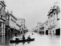
southward, providing the additional rainfall to the Brisbane River, Bremer River and Stanley River catchments to produce widespread and severe flooding...
16 KB (1,775 words) - 08:11, 30 March 2024
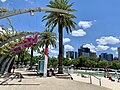
South Bank Parklands (redirect from The Parklands at South Bank, Brisbane)
1992. The South Bank Parklands are located on the southern bank of the Brisbane River, at South Bank, directly opposite the City. The parklands are connected...
22 KB (2,051 words) - 21:26, 30 May 2024
Stanley Street is a major street in Brisbane, Queensland. It carries the designation state route 41 for the entirety of its length and state route 10 between...
10 KB (520 words) - 10:00, 23 January 2024
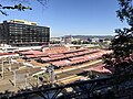
Roma Street railway station (redirect from Roma Street, Brisbane (bus routes))
Street Station will be affected by both the Cross River Rail and Brisbane Metro projects. The Brisbane Transit Centre complex was planned to be demolished...
22 KB (1,258 words) - 03:10, 3 April 2024

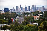
colloquially referred to as the "Brisbane CBD" or "the city". It is located on a point on the northern bank of the Brisbane River, historically known as Meanjin...
30 KB (2,955 words) - 02:14, 4 May 2024

William Jolly Bridge (redirect from William Jolly Bridge, Brisbane)
over the Brisbane River between North Quay in the Brisbane central business district and Grey Street in South Brisbane, within City of Brisbane, Queensland...
43 KB (5,829 words) - 13:25, 17 February 2024

South Bank, Queensland (redirect from South Bank (Brisbane))
precinct in Brisbane, Queensland, Australia. The precinct is located in the suburb of South Brisbane, on the southern bank of the Brisbane River. The South...
10 KB (884 words) - 03:57, 30 May 2024

Towns Victoria Walker Wearyan Wickham Wildman Wilton Rivers of Queensland template Waterways of Brisbane template A Albert Alice Annan Archer B Baffle Balonne...
55 KB (2,240 words) - 00:29, 3 January 2024
wharves along the bank of the Brisbane River. The first street in the area was called Stanley Quay, later to become Stanley Street. In December 1849, the...
81 KB (8,072 words) - 23:26, 4 June 2024

Brisbane are still manufactured of Brisbane tuff. The Brisbane River travels 344 kilometres (214 mi) across the Queensland state from Mount Stanley to...
26 KB (2,770 words) - 12:21, 25 May 2024

suburbs are informally grouped by Brisbane residents based on their relation to the Brisbane River and the Brisbane CBD. Generally the following rules...
35 KB (1,261 words) - 02:04, 12 May 2024

Somerset Dam (redirect from Stanley River Dam)
after the 1893 Brisbane floods caused severe damage to Brisbane River valley residents downstream. A commission of enquiry recommended Stanley Gorge as the...
15 KB (1,181 words) - 07:59, 30 April 2024
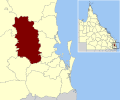
Somerset Region (redirect from Brisbane Valley)
along the Brisbane and Stanley Rivers for raising sheep. There were several exploration maps to guide them. John Oxley discovered the Brisbane River in December...
40 KB (3,214 words) - 14:41, 1 June 2024
Transport in Brisbane, the capital and largest city of Queensland, Australia, is provided by road, rail, river and bay ferries, footpaths, bike paths...
41 KB (4,442 words) - 13:48, 1 February 2024
locality. The east branch of Brisbane River flows from the north-east of the locality through to the south of locality. Mount Stanley is often described as the...
7 KB (589 words) - 06:02, 28 May 2024

South Brisbane Railway Easement is the heritage-listed remnants of a former railway branch line and siding at 412 Stanley Street, South Brisbane, Queensland...
8 KB (1,041 words) - 23:30, 22 December 2023

Russell House, which has since been demolished. Stanley Quay, later renamed Stanley Street, in Brisbane, Australia, was named after him at the time he...
28 KB (2,302 words) - 04:13, 11 May 2024

Railways in South East Queensland (redirect from List of Brisbane railway stations)
Gympie) to Brooloo in 1915. A line was opened from the first South Brisbane station at Stanley Street, Woolloongabba to Beenleigh in 1885, and extended to Southport...
55 KB (3,762 words) - 10:52, 10 May 2024

part of a line connecting the Ipswich line to the Brisbane River wharves at Stanley Street, South Brisbane, to provide a connection for coal mines exporting...
7 KB (606 words) - 18:49, 2 June 2024

Henry Plantagenet Somerset (section Stanley Dam)
district of Stanley in the Queensland Legislative Assembly from 1904 to 1920, and canvassed successfully for the extension of the Brisbane Valley railway...
15 KB (1,604 words) - 19:43, 18 October 2023

and has many original Queenslander houses. East Brisbane is bounded by the median of the Brisbane River to the north, Norman Park to the east, Coorparoo...
23 KB (2,133 words) - 23:31, 2 June 2024

South Brisbane railway station is a heritage-listed railway station at 133 Grey Street, South Brisbane, City of Brisbane, Queensland, Australia. It is...
18 KB (1,588 words) - 05:57, 18 April 2024