
The tellurometer was the first successful microwave electronic distance measurement equipment. The name derives from the Latin tellus, meaning Earth. The...
5 KB (438 words) - 09:19, 29 April 2025
Trevor Wadley (section Tellurometer)
Loop circuit for greater stability in communications receivers and the Tellurometer, a land surveying device. Wadley was born in 1920 in Durban, South Africa...
16 KB (1,619 words) - 20:38, 2 February 2024
Endurance Cliffs. Mapped by the United States Geological Survey (USGS) from tellurometer surveys and Navy air photos, 1960–62. Named by Advisory Committee on...
8 KB (1,364 words) - 19:18, 3 December 2024
completely mapped by the United States Geological Survey (USGS) from tellurometer surveys and US Navy air photos, 1959–63. Named by the NZ-APC for Captain...
21 KB (3,482 words) - 23:58, 20 February 2025
Elizabeth Range. Mapped by the United States Geological Survey (USGS) from tellurometer surveys and Navy air photos, 1960-62. Named by the United States Advisory...
6 KB (811 words) - 13:37, 2 May 2025
Surveyor's chain Surveyor's compass Tachymeter (surveying) Tape (surveying) Tellurometer Theodolite Half theodolite Plain theodolite Simple theodolite Great theodolite...
2 KB (129 words) - 19:19, 4 October 2023

the north slopes of the Queen Elizabeth Range. Mapped by the USGS from tellurometer surveys and Navy air photos, 1960-62. Named by US-ACAN for Edgar L. Doss...
9 KB (1,414 words) - 20:44, 31 October 2024
Sherwin Peak was mapped by the United States Geological Survey (USGS) from tellurometer surveys and Navy air photos, 1960–62. It was named by the United States...
5 KB (681 words) - 15:56, 19 July 2024
Lankester and Hoffman Point to the Ross Ice Shelf. Mapped by the USGS from tellurometer surveys and Navy air photos, 1959-63. Named by US-ACAN for Cdr. Lloyd...
7 KB (1,044 words) - 13:56, 12 March 2024
of Longstaff Peaks into the Ross Ice Shelf. }Mapped by the USGS from tellurometer surveys (1961-62) and Navy air photos (1960). Named by US-ACAN for Cdr...
16 KB (2,356 words) - 07:08, 2 February 2025
northeast slopes of the Queen Elizabeth Range. Mapped by the USGS from tellurometer surveys and Navy air photos, 1960-62. Named by US-ACAN for Egon Dorrer...
7 KB (1,046 words) - 14:03, 22 December 2023

speed of light in air that used a toothed wheel. Laser rangefinder Lidar Tellurometer Rüeger 2012, p. 15. Bergstrand 1952. Froome & Essen 1969. Bergstrand...
5 KB (466 words) - 15:05, 18 March 2025
Tachymeter Taximeter, measure usually includes a time component as well Tellurometer Travelling microscope Angular measuring instrument Altimeter, height...
26 KB (3,435 words) - 10:26, 27 May 2025
the process of industrialising a unique South African invention, the Tellurometer, the first successful microwave electronic distance measurement equipment...
42 KB (4,480 words) - 20:04, 25 February 2025

Tentacle Ridge. Mapped by the United States Geological Survey (USGS) from tellurometer surveys and Navy air photos, 1959-63. Named by the Advisory Committee...
18 KB (2,604 words) - 01:03, 17 May 2024
Peaks were mapped by the United States Geological Survey (USGS) from tellurometer surveys and Navy air photos, 1960–62. They were named by the United States...
4 KB (608 words) - 22:40, 25 July 2024
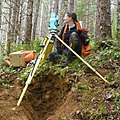
accurate measurement of long distances. Trevor Lloyd Wadley developed the Tellurometer during the 1950s. It measures long distances using two microwave transmitter/receivers...
57 KB (7,282 words) - 21:19, 23 June 2025
ridge. They were mapped by the United States Geological Survey from tellurometer surveys and Navy air photos, 1959–63, and named descriptively by the...
3 KB (388 words) - 14:00, 19 December 2023
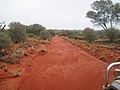
rediscovering Vokes Hill while surveying the track, as a new device called a Tellurometer was being introduced. It used radio waves for distance measurement, and...
10 KB (813 words) - 21:58, 6 July 2024

northwest of Mount Kopere in the Cobham Range. Mapped by the USGS from tellurometer surveys and Navy air photos, 1960-62. Named by the Advisory Committee...
11 KB (1,204 words) - 23:59, 14 December 2023
8 km) east of Smith Bluff in the Nash Range. Mapped by the USGS from tellurometer surveys and Navy air photos, 1960-62. Named by US-ACAN for Karl E. Ricker...
12 KB (1,641 words) - 16:13, 31 August 2024
Henry Mesa. Mapped by the United States Geological Survey (USGS) from tellurometer surveys and Navy air photos, 1959–63. Named by Advisory Committee on...
11 KB (1,517 words) - 12:16, 23 June 2024
1964, and a member of one of the survey parties which carried out a tellurometer traverse passing through the Leckie Range in 1965. "Leslie Peak". Geographic...
943 bytes (139 words) - 12:55, 19 July 2024
Wales Glacie. Mapped by the United States Geological Survey (USGS) from tellurometer surveys and Navy air photos, 1960-62. Named by the United States Advisory...
4 KB (568 words) - 23:35, 13 March 2025

Pretorius at the University of Pretoria in Pretoria, South Africa 1959, Tellurometer was the first successful microwave electronic distance measurement equipment...
16 KB (1,746 words) - 10:32, 25 June 2025
Shelf, Antarctica. It was mapped by the U.S. Geological Survey from tellurometer surveys and Navy air photos, 1959–63, and named by the Advisory Committee...
938 bytes (139 words) - 20:23, 25 June 2025

Glacier in the northwest part of the Miller Range. Mapped by the USGS from tellurometer surveys and Navy air photos, 1960–62. Named by US-ACAN for Dr. Mort D...
16 KB (2,018 words) - 20:25, 8 April 2025
the Holyoake Range of the Churchill Mountains. Mapped by the USGS from tellurometer surveys and Navy air photos, 1960–62. Named by US-ACAN for Paul L. Adams...
12 KB (1,401 words) - 07:08, 2 February 2025
(20 km; 13 mi) west-southwest of Junction Spur. Mapped by the USGS from tellurometer surveys and Navy air photos, 1959-63. Named by US-ACAN for Ralph E. Ash...
9 KB (1,516 words) - 12:30, 13 March 2024
Lyttelton on the south side of Nimrod Glacier. Mapped by the USGS from tellurometer surveys and Navy air photos, 1960-62. Named by US-ACAN for William J...
7 KB (896 words) - 08:17, 4 May 2024