
The transverse Mercator map projection (TM, TMP) is an adaptation of the standard Mercator projection. The transverse version is widely used in national...
40 KB (4,647 words) - 19:20, 21 April 2025

The Universal Transverse Mercator (UTM) is a map projection system for assigning coordinates to locations on the surface of the Earth. Like the traditional...
18 KB (2,858 words) - 13:14, 29 May 2025
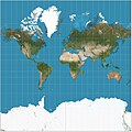
The Mercator projection (/mərˈkeɪtər/) is a conformal cylindrical map projection first presented by Flemish geographer and mapmaker Gerardus Mercator in...
49 KB (6,858 words) - 10:56, 5 June 2025

The oblique Mercator map projection is an adaptation of the standard Mercator projection. The oblique version is sometimes used in national mapping systems...
5 KB (555 words) - 00:19, 1 September 2024

Northern Ireland (OSNI) in 2001. The name is derived from the Transverse Mercator projection it uses and the fact that it is optimised for the island of...
7 KB (698 words) - 03:33, 9 March 2025

coordinate system for Israel. The name is derived from the transverse Mercator projection it uses and the fact that it is optimized for Israel. ITM has...
5 KB (447 words) - 08:31, 24 April 2025

constant. These are some conformal projections: Mercator: Rhumb lines are represented by straight segments Transverse Mercator Stereographic: Any circle of...
59 KB (6,451 words) - 10:08, 9 May 2025
Universal Transverse Mercator coordinate system. MTM uses a transverse Mercator projection with zones spaced 3° of longitude apart. The coordinate system...
471 bytes (50 words) - 13:52, 3 October 2019
drawn as a straight line on the map.) Transverse Mercator projection Gauss–Krüger coordinate system (This projection preserves lengths on the central meridian...
11 KB (1,211 words) - 00:36, 1 September 2024

Projected coordinate system (section Projections)
map projection. Each projected coordinate system, such as "Universal Transverse Mercator WGS 84 Zone 26N," is defined by a choice of map projection (with...
21 KB (2,805 words) - 00:44, 11 June 2025

Nevertheless, the use of the Cassini projection has largely been superseded by the transverse Mercator projection, at least with central mapping agencies...
5 KB (771 words) - 00:03, 1 September 2024
based on either a transverse Mercator projection or a Lambert conformal conic projection. The choice between the two map projections is based on the shape...
7 KB (965 words) - 15:06, 26 February 2024
Transverse Mercator projection has many implementations. Louis Krüger in 1912 developed one of his two implementations that expressed as a power series...
25 KB (4,902 words) - 15:08, 22 November 2024
meridian, measured on the Transverse Mercator projection N = distance north of the equator, measured on the Transverse Mercator projection ε = 2 r − 1 ( r − 1...
9 KB (1,575 words) - 23:55, 25 March 2025

Scale (map) (section Mercator projection)
prompted the development of the transverse Mercator projections in which a meridian is treated 'like an equator' of the projection so that we obtain an accurate...
35 KB (5,382 words) - 16:11, 10 June 2025

parallels (as red lines) on the commonly used Mercator projection and the Transverse Mercator projection. On the former the parallels are horizontal and...
47 KB (6,166 words) - 16:38, 30 May 2025

Dymaxion map (redirect from Dymaxion projection)
over other projections for world maps. It has less distortion of relative size of areas, most notably when compared to the Mercator projection; and less...
13 KB (1,367 words) - 17:11, 16 April 2025

similar to the Palestine Grid but used the transverse Mercator projection. The difference between the two projections was only a few metres. After the establishment...
5 KB (519 words) - 00:57, 6 April 2024

country (projected to the Airy ellipsoid then flattened using the Transverse Mercator projection), or as the point farthest from the boundary of the country...
13 KB (1,218 words) - 17:37, 7 October 2024

Tissot's indicatrix (category Map projections)
The transverse Mercator projection with Tissot's indicatrices The stereographic projection with Tissot's indicatrices The sinusoidal projection with...
19 KB (2,695 words) - 06:11, 16 May 2025
Motor Philippines Theban Mapping Project, of archaeologic sites Transverse Mercator projection 2,2,6,6-Tetramethylpiperidine, an organic chemistry reagent...
2 KB (253 words) - 09:18, 29 April 2025
National Grid reference system Bermuda National Grid, a kind of Transverse Mercator projection Banning Municipal Airport (IATA airport code) Bingen-White Salmon...
1 KB (177 words) - 00:52, 13 January 2024

It largely preserves the familiar shapes of the Mercator projection while modestly reducing Mercator's distortion. Polar regions are subject to extreme...
4 KB (547 words) - 10:45, 30 December 2023

systems having moved onto conformal projection systems, typically modeled on the transverse Mercator projection. The rectangular polyconic has one specifiable...
3 KB (399 words) - 18:49, 20 June 2024

State University provides the following parameters for the projection: Jordan Transverse Mercator Geographic Coordinate System: GCS_International_1924 Datum:...
2 KB (275 words) - 00:38, 5 November 2024

cylindric projection and its virtues, specifically disparaging Mercator's projection.) Weisstein, Eric W. "Cylindrical Equal-Area Projection." From MathWorld—A...
11 KB (723 words) - 18:24, 21 May 2025

proposed by Émile Guyou in 1887, and a transverse aspect was proposed by Oscar S. Adams in 1925. The projection has seen use in digital photography for...
14 KB (1,631 words) - 11:25, 1 April 2025
example, "Universal Transverse Mercator WGS 84 Zone 16N") comprises a choice of Earth ellipsoid, horizontal datum, map projection (except in the geographic...
15 KB (1,570 words) - 12:19, 7 May 2025

a superior alternative to the commonly used Mercator projection, on the basis that the Mercator projection greatly distorts the relative sizes of regions...
18 KB (2,100 words) - 07:18, 2 June 2025
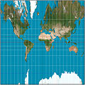
illustration of projection, rather than for practical maps. Its vertical stretching is even greater than that of the Mercator projection, whose construction...
3 KB (334 words) - 05:14, 5 May 2025