
A triangulation station, also known as a trigonometrical point, and sometimes informally as a trig, is a fixed surveying station, used in geodetic surveying...
15 KB (1,741 words) - 05:08, 9 May 2025

In trigonometry and geometry, triangulation is the process of determining the location of a point by forming triangles to the point from known points...
6 KB (672 words) - 00:40, 31 January 2025

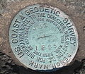
The Meades Ranch Triangulation Station is a survey marker in Osborne County in the state of Kansas in the Midwestern United States. The marker was initially...
15 KB (1,486 words) - 23:10, 30 March 2025
position). Horizontal position markers used for triangulation are also known as triangulation stations. Benchmarking is the hobby of "hunting" for these...
10 KB (1,243 words) - 10:35, 27 May 2025
Wilseder Berg (section Triangulation station)
the Wilseder Berg, amongst others, as a triangulation station for his land surveys. Other central triangulation points were the Falkenberg (150 m above...
6 KB (640 words) - 14:43, 15 June 2023
Look up triangulation in Wiktionary, the free dictionary. Triangulation is the process of determining the location of a point by forming triangles to...
3 KB (409 words) - 01:34, 21 November 2022
based on a triangulation station at the junction of the transcontinental triangulation arc of 1899 on the 39th parallel north and the triangulation arc along...
13 KB (1,631 words) - 10:15, 27 May 2025

The Retriangulation of Great Britain was a triangulation project carried out between 1935 and 1962 that sought to improve the accuracy of maps of Great...
25 KB (3,016 words) - 19:05, 22 May 2025

Wilkie Sugar Loaf (section Triangulation station)
Natural Resources Canada Geodetic Survey Division Station, Unique Number (Station Number): 23107, Station Name "SUGAR LOAF 19659", is located near the summit...
10 KB (765 words) - 13:54, 28 May 2025

first modern survey of the Philippine Islands. The execution of the triangulation of the Philippine Islands extended over almost as long a time as the...
4 KB (374 words) - 16:11, 12 April 2025

Geodetic control network (section Triangulation)
Map ED50 Geodetic datum GRS80 History of geodesy Survey marker Triangulation station Trigonometry Rear Adm. John D. Bossler. "Standards and Specifications...
7 KB (718 words) - 14:11, 14 May 2024

of Khasan. Three granite shoreside markers, which are in effect triangulation stations, are specified in the 1985 treaty defining the tripoint, which is...
8 KB (825 words) - 13:38, 3 November 2024

Wilkie Sugar Loaf trail (section Triangulation station)
Natural Resources Canada Geodetic Survey Division Station, Unique Number (Station Number): 23107, Station Name "SUGAR LOAF 19659", is located near the summit...
7 KB (684 words) - 22:47, 26 October 2024
trees and marked with four National Geodetic Survey triangulation station disks; a standard station disk marked with an equilateral triangle and three...
8 KB (750 words) - 09:37, 5 January 2025
Ordnance Survey triangulation station, colloquially known as 'The Golf Ball' due to its resemblance to a golf ball on a tee. The station was erected in...
4 KB (231 words) - 00:27, 20 February 2025

Prefecture. It has an elevation of 503 m (1,650 ft), but Yonaha-dake triangulation station is located at the next peak of elevation of 498 m (1,634 ft). "Mount...
5 KB (450 words) - 19:28, 9 August 2024

where the Alp, Urús, Das and Bagà municipal limits meet. There is a triangulation station (282081001) at the summit. Part of its slopes are home to the ski...
1 KB (104 words) - 20:51, 21 April 2025
is a man made rock pile that sits alongside an Ordnance Survey triangulation station. The Cornish word for "cairn" is karn (from karnow, meaning "rock...
19 KB (1,903 words) - 04:24, 12 February 2025

of this sequence. Devil's Slide was the location of a military triangulation station and observation site (known as Devil’s Bunker) used during World...
9 KB (990 words) - 00:34, 9 April 2025

abandoned village of La Mussara, located in the range. There is a triangulation station at the summit (ref. 262132001). Prades Mountains Mountains of Catalonia...
1 KB (96 words) - 00:19, 22 December 2024

features a hermitage, a cave, the remains of a medieval castle and a triangulation station. The mountain rises 530 meters (1,740 ft) and is known for its unique...
9 KB (871 words) - 21:55, 29 October 2024

Yow Hill. The summit is marked with a National Geodetic Survey triangulation station disk and three radio towers. A sign cautions visitors to prepare...
4 KB (370 words) - 05:41, 7 January 2025

Ridge where the United States Coast and Geodetic Survey installed a triangulation station in 1884. The Clinch River flows southwestward for 300 miles (480 km)...
8 KB (834 words) - 15:22, 23 May 2025
Resource Description Framework (RDF) data Trig points, also known as triangulation stations Trig Paxson Van Palin, son of former Alaska Governor Sarah Palin...
678 bytes (117 words) - 21:12, 10 September 2024

of the aforementioned state border, there is a triangulation station of the German Primary Triangulation Network at a height of 843.1 m above NN (i.e....
5 KB (543 words) - 20:13, 20 August 2024
1927), an ellipsoid of revolution that is at mean sea level beneath triangulation station Meades Ranch, Kansas (not Earth-centered); relative to NAD 83, an...
21 KB (2,523 words) - 00:14, 30 August 2024

states is in Smith County near Lebanon. Until 1989, the Meades Ranch Triangulation Station in Osborne County was the geodetic center of North America: the...
197 KB (17,513 words) - 20:59, 4 May 2025

the base of the fire tower there is a National Geodetic Survey triangulation station disk. The entire firetower structure is enclosed within a fence...
4 KB (483 words) - 17:19, 19 March 2025

of the triangulation station "Bandai", installed in 1904, had been employed as the official altitude of Mount Bandai. However, after the station disappeared...
8 KB (967 words) - 03:28, 21 February 2025

Žárový vrch (section Triangulation stations)
of the Hrubý Jeseník called Keprník Mountains. There is a major triangulation station on the summit slope, marked on geodetic maps with the number 14...
39 KB (3,139 words) - 06:45, 19 May 2025