
Upper Table Rock and Lower Table Rock are two prominent volcanic plateaus located just north of the Rogue River in Jackson County, Oregon, U.S. Created...
47 KB (4,490 words) - 08:15, 25 May 2025
in Missouri and Arkansas Table Rock State Park (South Carolina) Table Rock Wilderness in northwestern Oregon Upper and Lower Table Rock, volcanic plateaus...
919 bytes (150 words) - 03:06, 9 May 2025
City and Sams Valley. The topographic features known as Upper and Lower Table Rock are slightly west of the community. Between 1853 and 1856, the Table Rock...
5 KB (295 words) - 05:34, 25 June 2024

River Valley (Oregon). Jefferson (Pacific state) Roxy Ann Peak Upper and Lower Table Rock Psathyrella aquatica "Rich Gulch". Southern Oregon History Revised...
8 KB (677 words) - 18:09, 15 September 2024
1954. The area is adjacent to TouVelle State Recreation Site and the Upper and Lower Table Rock lava formations. Kenneth George Denman was born in Corvallis...
9 KB (1,003 words) - 00:53, 5 March 2025

other reservations. The reservation was in Southern Oregon, between Upper Table Rock and Evans Creek. In 2025, the Confederated Tribes of Siletz Indians announced...
7 KB (716 words) - 11:18, 24 February 2025
through Eagle Point and enters the larger stream a few miles to the west near TouVelle State Recreation Site and Upper and Lower Table Rock. This region experiences...
16 KB (1,424 words) - 04:54, 5 June 2025

Jackson County, Oregon (category States and territories established in 1852)
located along the stream. It connects with the Rogue River near the Upper and Lower Table Rock lava formations. Barneburg Hill Fredenburg Butte Obenchain Mountain...
28 KB (2,539 words) - 23:49, 7 June 2025

lead to the "upper contour path" which traverses the front (north face) of Devil's Peak and Table Mountain at 500 m, to just beyond the Lower Cable Station...
57 KB (6,545 words) - 22:33, 17 April 2025

Commons has media related to Pilot Rock (Jackson County, Oregon). Roxy Ann Peak Upper and Lower Table Rock "Pilot Rock" (PDF). Bureau of Land Management...
11 KB (1,001 words) - 02:27, 23 November 2024
Rogue River Wars (category Wars between the United States and Native Americans)
and arrows and managed to hold off a group of "more than 300 ... dragoons, militiamen and volunteers". Cayuse War Table Rock Indian Reservation Upper...
17 KB (2,017 words) - 03:15, 10 June 2025

Mount Bailey (Oregon) (section Geography and geology)
Klamath tradition, their medicine men and priests would feast on the mountain's summit and commune with the upper world. Mount Bailey is part of the High...
9 KB (930 words) - 10:34, 8 June 2025

Roxy Ann Peak (section Geology and soils)
Rock, the Crater Lake rim, and even Mount Thielsen, 66 miles (106 km) to the north, and Mount Shasta, 72 miles (116 km) to the south. Upper and Lower...
42 KB (3,874 words) - 05:05, 25 August 2024

Oregon, United States, just west of U.S. Route 97 between the towns of Bend, and Sunriver in Deschutes County. It is part of a system of small cinder cones...
10 KB (1,029 words) - 22:23, 24 January 2025

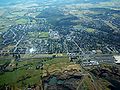
Medford, Oregon (category Official website different in Wikidata and Wikipedia)
from the original on January 12, 2012. Retrieved December 21, 2012. "Lower Table Rock". Nature.org. January 19, 2008. Archived from the original on March...
94 KB (7,510 words) - 01:12, 18 April 2025

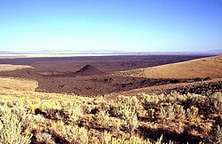
Hole-in-the-Ground is a large maar (volcanic explosion crater) in the Fort Rock–Christmas Lake Valley basin of Lake County, central Oregon, northeast of...
4 KB (344 words) - 00:12, 12 August 2024
(200 km) southwest of Boise, Idaho and 18 miles (30 km) northwest of Jordan Valley, Oregon. The craters are free and open to the public all year. List...
3 KB (279 words) - 23:33, 15 May 2025

River (Natural systems; and botanical, fish, and cultural values 603 acres (2.44 km2), Coos Bay Office) Upper and Lower Table Rock Copper Globe (historic...
22 KB (2,434 words) - 04:44, 3 June 2025
the earth shook for days, and the mountain boiled inside. It boiled over, and hot rocks came out of the top of it. Flames and smoke rose high in the air...
4 KB (396 words) - 21:15, 20 April 2024

flows, cinder cones, and maars. The reexamination of radiocarbon dates from older studies and interpretation of paleomagnetic data and new radiocarbon dates...
8 KB (405 words) - 23:51, 15 May 2025
the rock, causing the lava to collapse. Hladky, Frank R. (July 1998). "Age, chemistry, and origin of capping lava at Upper Table Rock and Lower Table Rock...
2 KB (136 words) - 21:58, 23 April 2025

The water table is the upper surface of the phreatic zone or zone of saturation. The zone of saturation is where the pores and fractures of the ground...
9 KB (1,074 words) - 10:38, 25 April 2025

Powell Butte (section Geography and geology)
edifices and lava flows in the Portland–Vancouver metropolitan area, with the possibility of more volcanic deposits buried under sedimentary rock layers...
14 KB (1,441 words) - 01:08, 25 May 2025
Tolo, Oregon (section Table Rock Treaty and Fort Lane)
Table Rock Treaty established the first reservation in the Pacific Northwest, the Table Rock Indian Reservation, which encompassed Upper and Lower Table Rock...
8 KB (773 words) - 02:19, 23 February 2025

Three Fingered Jack (section Geology and subfeatures)
summit and upper cone. Lava flows near the summit have an average thickness of 3 feet (0.91 m). Secondary volcanic craters produced lava flows and pyroclastic...
30 KB (3,228 words) - 05:34, 7 January 2025

surrounding Mount Mazama, it has a lower density of volcanic vents, no dacitic or silicic volcanic rock, and a lower volume of eruptive material produced...
26 KB (3,029 words) - 18:53, 3 January 2025
Weald Clay (redirect from Upper Weald Clay)
Weald Clay Formation is a Lower Cretaceous sedimentary rock unit underlying areas of South East England, between the North and South Downs, in an area called...
17 KB (1,189 words) - 17:43, 31 May 2025
Lias Group (redirect from Upper Lias)
disappearing. In southern England, the Lias Group is often divided into Lower, Middle and Upper subgroups. In Southern England the Lias is divided into the following...
5 KB (570 words) - 19:06, 3 September 2022

the lower Wellington outcrop. It is associated with "Carlton Insect Beds", although a number of other insect beds are known within the upper and lower Wellington...
29 KB (3,013 words) - 22:21, 13 June 2025
The Lower Maleri Formation is a sedimentary rock formation found in Andhra Pradesh and Telangana, India. It is the lowermost member of the Pranhita–Godavari...
6 KB (290 words) - 17:24, 30 May 2025