
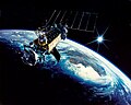
The Visible Infrared Imaging Radiometer Suite (VIIRS) is a sensor designed and manufactured by the Raytheon Company on board the polar-orbiting Suomi...
8 KB (798 words) - 06:19, 6 February 2025

Mapping and Profiler Suite (OMPS) equipment, was designed by Ball Aerospace & Technologies. The Visible Infrared Imaging Radiometer Suite (VIIRS) and the Common...
17 KB (1,546 words) - 06:21, 6 February 2025

Earth about 14 times each day. Its five imaging systems include: The Visible Infrared Imaging Radiometer Suite (VIIRS) is the largest instrument aboard...
18 KB (1,780 words) - 19:47, 5 November 2024

in six channels. The AVHRR has been succeeded by the Visible Infrared Imaging Radiometer Suite, carried on the Joint Polar Satellite System spacecraft...
23 KB (2,852 words) - 13:25, 16 June 2025

global distribution of ozone. The Visible Infrared Imaging Radiometer Suite (VIIRS) takes global visible and infrared observations of land, ocean, and...
17 KB (1,676 words) - 03:58, 11 May 2025

The Blue Marble (section Imaging series 2001–2004)
band" of the Visible Infrared Imaging Radiometer Suite (VIIRS), which detects light in a range of wavelengths from green to near-infrared, and uses filtering...
34 KB (3,479 words) - 14:38, 19 June 2025
for Resource Management System NASA Earth Data. "VIIRS; Visible Infrared Imaging Radiometer Suite". NASA. Retrieved 6 March 2025. UN-SPIDER. "Detecting...
16 KB (1,099 words) - 22:58, 27 May 2025

improved protection against enemy intercept and jamming. Visible Infrared Imaging Radiometer Suite (VIIRS), was developed by Raytheon Space and Airborne...
52 KB (4,918 words) - 17:37, 23 June 2025
The Day/Night Band, the high sensitivity channel of the Visible Infrared Imaging Radiometer Suite (VIIRS) on board the Suomi NPP and Joint Polar Satellite...
1 KB (214 words) - 16:56, 6 November 2024

Ocean color (category Pages using multiple image with auto scaled images)
Sentinel-3B Visible Infrared Imaging Radiometer Suite (VIIRS) on Suomi-NPP (SNPP) and NOAA-20 (JPSS1) satellites Operational Land Imager (OLI) on Landsat-8...
41 KB (4,288 words) - 23:39, 25 May 2025

NOAA-19 (category Television Infrared Observation Satellites)
Advanced Very High Resolution Radiometer/3 (AVHRR/3) is the primary imaging system and consists of visible, near infrared (IR) and thermal IR channels...
19 KB (1,809 words) - 17:03, 29 April 2025
space. JPSS Sensors/Instruments: Visible Infrared Imaging Radiometer Suite (VIIRS) takes global visible and infrared observations of land, ocean, and...
21 KB (2,481 words) - 16:23, 6 December 2024
A microwave radiometer (MWR) is a radiometer that measures energy emitted at one millimeter-to-metre wavelengths (frequencies of 0.3–300 GHz) known as...
20 KB (2,395 words) - 00:17, 20 June 2025

including SeaWiFS, and instruments including the NASA/NOAA Visible Infrared Imaging Radiometer Suite and the Moderate Resolution Imaging Spectroradiometer....
35 KB (3,345 words) - 02:26, 20 June 2025

NOAA-16 (category Television Infrared Observation Satellites)
instrument providing imaging and radiometric data in the visible, near-IR and infrared of the same area on the Earth. Data from the visible and near-IR channels...
23 KB (2,830 words) - 15:34, 13 May 2025

NOAA-17 (category Television Infrared Observation Satellites)
instrument providing imaging and radiometric data in the visible, near-IR and infrared of the same area on the Earth. Data from the visible and near-IR channels...
23 KB (2,779 words) - 15:34, 13 May 2025

Weather satellite (redirect from Satellite Cloud Image)
recording cloud cover during the day Infrared: 3.9–7.3 μm (water vapor), 8.7–13.4 μm (thermal imaging) Visible-light images from weather satellites during local...
30 KB (3,509 words) - 01:22, 25 March 2025

Resolution Radiometer (AVHRR), Along Track Scanning Radiometers (AASTR), Visible Infrared Imaging Radiometer Suite (VIIRS), the Atmospheric Infrared Sounder...
28 KB (2,648 words) - 00:58, 24 May 2025
GOES-16 (redirect from Advanced Baseline Imager)
imaging radiometer, ABI takes images of the Earth with 16 spectral bands, including two visible channels, four near-infrared channels, and ten infrared channels...
82 KB (7,679 words) - 17:40, 24 June 2025

3 Ocean and Land Colour Instrument (OLCI), and NOAA's Visible Infrared Imaging Radiometer Suite (VIIRS) on board the Joint Polar Satellite System (JPSS)...
9 KB (1,035 words) - 01:03, 26 April 2024
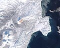
Martin Fire (category Wildfire articles needing images)
to gather data on the magnitude of damage and locate hot spots using an infrared sensor. The fire destroyed grazing areas and a small building. It destroyed...
6 KB (563 words) - 03:34, 10 March 2025

land discipline leader for the Suomi-NPP and NOAA-20 Visible Infrared Imaging Radiometer Suite (VIIRS) science team, a worldwide group of investigators...
5 KB (465 words) - 21:26, 11 March 2025

land discipline leader for the Suomi-NPP and NOAA-20 Visible Infrared Imaging Radiometer Suite (VIIRS) science team, a worldwide group of investigators...
94 KB (11,282 words) - 03:07, 11 June 2025
Earth Observing System (category Pages using multiple image with auto scaled images)
satellite will include Visible Infrared imaging Radiometer, Advanced Technology Microwave Sounder and Ozone Mapping and Profiler Suite. The data collected...
29 KB (2,019 words) - 00:35, 20 June 2025
the shape and dimension of the earlier series, featuring improved infrared radiometers. The designation DMSP-2 (Defense Meteorological Satellite Program...
44 KB (2,661 words) - 14:08, 4 June 2025
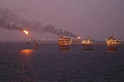
"Methods for Global Survey of Natural Gas Flaring from Visible Infrared Imaging Radiometer Suite Data". Energies. 9 (9): 14. doi:10.3390/en9010014. "Earth...
41 KB (4,064 words) - 03:39, 26 April 2025

land discipline leader for the Suomi-NPP and NOAA-20 Visible Infrared Imaging Radiometer Suite (VIIRS) science team, a worldwide group of investigators...
63 KB (6,933 words) - 04:57, 10 June 2025
November 2015). "Esperance fires: Green, crops toll stands out in satellite images". Perth Now. News Corp. Retrieved 7 May 2016. Jorgensen, Cari (3 December...
65 KB (6,990 words) - 04:52, 18 December 2024

Operational Linescan System (OLS) nighttime lights imagery, Visible Infrared Imaging Radiometer Suite (VIIRS) and Landsat. Seto edited a collection of papers...
22 KB (2,052 words) - 16:14, 5 May 2025

Juno (spacecraft) (category Pages using multiple image with auto scaled images)
JunoCam and the Jovian Infrared Auroral Mapper (JIRAM) were designed to endure at least eight orbits, while the Microwave Radiometer (MWR) was made to endure...
111 KB (9,344 words) - 17:58, 21 June 2025