
World Geodetic System (redirect from WGS 84)
Geodetic System (WGS) is a standard used in cartography, geodesy, and satellite navigation including GPS. The current version, WGS 84, defines an Earth-centered...
24 KB (2,831 words) - 01:25, 11 May 2024
system (GPS), the ellipsoid and datum WGS 84 it uses has supplanted most others in many applications. The WGS 84 is intended for global use, unlike most...
29 KB (3,073 words) - 16:06, 31 December 2023
datum is used. Examples of global datums include World Geodetic System (WGS 84, also known as EPSG:4326), the default datum used for the Global Positioning...
21 KB (2,379 words) - 15:52, 15 May 2024
GCJ-02 and WGS-84, for languages including C#, C, Go, Java, JavaScript, PHP, Python, R, and Ruby. They appear to be based on leaked code for the WGS to GCJ...
28 KB (2,997 words) - 22:54, 4 March 2024

Web Mercator, Google Web Mercator, Spherical Mercator, WGS 84 Web Mercator or WGS 84/Pseudo-Mercator is a variant of the Mercator map projection and is...
15 KB (1,702 words) - 11:03, 26 January 2024
and approx. 2° 0′ 5″ W (WGS 84). OSGB 36 was also used by Admiralty nautical charts until 2000[citation needed] after which WGS 84 has been used. A geodetic...
19 KB (2,130 words) - 10:53, 28 May 2024
ED50 (section Datum shift between ED50 and WGS 84)
Earth and was widely used around the world until the 1980s when GRS 80 and WGS 84 were established. Many national coordinate systems of Gauss–Krüger are defined...
8 KB (927 words) - 18:06, 2 May 2024
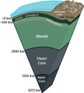
whole. The following radii are derived from the World Geodetic System 1984 (WGS-84) reference ellipsoid. It is an idealized surface, and the Earth measurements...
40 KB (4,267 words) - 13:36, 3 June 2024

83(1986) is based on the GRS 80 spheroid, as was WGS 84, so many older publications indicate no difference. WGS 84 subsequently changed to a slightly less flattened...
13 KB (1,613 words) - 17:17, 5 May 2024
Harpoon missile WGS 84 - The latest revision of the World Geodetic System, a fixed global reference frame for the Earth. The house number of 84 Avenue Foch...
6 KB (877 words) - 11:05, 4 June 2024
particular SRS specification (for example, "Universal Transverse Mercator WGS 84 Zone 16N") comprises a choice of Earth ellipsoid, horizontal datum, map...
15 KB (1,546 words) - 06:12, 22 May 2024

that is used for the Global Positioning System (GPS) is the geocentric WGS 84, which currently includes its own ellipsoid definition. Other local datums...
9 KB (904 words) - 13:39, 7 January 2024
have been adopted also for all modern reference ellipsoids. The ellipsoid WGS-84, widely used for mapping and satellite navigation has f close to 1/300 (more...
19 KB (2,379 words) - 23:35, 14 April 2024

other realization of the ITRF. The difference between the latest as of 2006 WGS 84 (frame realisation G1150) and the latest ITRF2000 is only a few centimeters...
9 KB (777 words) - 16:49, 25 May 2024
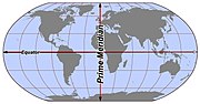
surface. The length of a meridian on a modern ellipsoid model of Earth (WGS 84) has been estimated as 20,003.93 km (12,429.87 mi). The first prime meridian...
18 KB (2,257 words) - 23:05, 4 June 2024

establishment of reference meridians for space-based location systems such as WGS-84 (which the GPS relies on) or to the fact that errors gradually crept into...
14 KB (1,510 words) - 19:50, 2 June 2024
define the use of CRSes other than WGS-84. This is primarily intended to cope with the case of another CRS replacing WGS-84 as the predominantly used one,...
14 KB (1,850 words) - 08:23, 8 December 2023
the world, WGS 84). Baidu alleges that adopting BD-09 "protects users' privacy". The Baidu Maps API documentation specifies that "real" (WGS 84) GPS coordinates...
15 KB (1,063 words) - 00:48, 20 May 2024
include waypoints, routes, and tracks: A waypoint (wptType) consists of the WGS 84 (GPS) coordinates of a point and possibly other descriptive information...
6 KB (570 words) - 14:20, 28 May 2024

meeting of 1979 has an equatorial radius of 6,378.137 km (3,963.191 mi). The WGS 84 (World Geodetic System 1984) which is a standard for use in cartography...
32 KB (2,392 words) - 17:27, 29 May 2024
Positioning System (GPS) operated by the United States Space Force, and of WGS 84 and its two formal versions, the ideal International Terrestrial Reference...
13 KB (767 words) - 19:40, 26 March 2024
maps of China use the GCJ-02 coordinate system, which is offset from the WGS-84 system used in most of the world. google.cn/maps (formerly Google Ditu)...
160 KB (13,124 words) - 13:11, 31 May 2024
global datums, such as WGS 84. The standard NIMA TM 8350.2, Appendix D, lists MRE transforms from several local datums to WGS 84, with accuracies of about...
34 KB (5,200 words) - 12:36, 3 June 2024
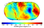
Texas Space Grant Consortium. 11 February 2004. Retrieved 22 January 2018. "WGS 84, N=M=180 Earth Gravitational Model". NGA: Office of Geomatics. National...
26 KB (3,056 words) - 23:24, 18 April 2024
support SRIDs issued by other organizations (such as Esri). EPSG:4326 - WGS 84, latitude/longitude coordinate system based on the Earth's center of mass...
5 KB (448 words) - 13:19, 16 January 2024

Geographical mile Arabic mile Humerfelt, Sigurd (26 October 2010). "How WGS 84 defines Earth". Archived from the original on 24 April 2011. Retrieved 29...
21 KB (2,446 words) - 18:08, 21 April 2024
geodesy, generally it is expressed by its reciprocal. For example, in the WGS 84 spheroid used by today's GPS systems, the reciprocal of the flattening 1...
24 KB (2,821 words) - 17:27, 4 June 2024
spherical harmonics. XGM2020 was also released recently. ETRS89 NAD83 "WGS 84 Earth Gravitational Model". earth-info.nga.mil. Archived from the original...
11 KB (1,292 words) - 10:37, 6 May 2024
international ITRS, the European ETRS89 and (with a 0,1 mm rounding error) for WGS 84 used for the American Global Navigation Satellite System (GPS). Geodesy...
7 KB (1,084 words) - 09:06, 26 May 2024
kilometers (following GRS 80 and WGS 84 standards). 40075.0167, the length of the Equator in kilometers (following GRS 80 and WGS 84 standards). 384399, the semi-major...
57 KB (3,872 words) - 14:32, 2 June 2024