A Web Map Tile Service (WMTS) is a standard protocol for serving pre-rendered or run-time computed georeferenced map tiles over the Internet. The specification...
3 KB (326 words) - 21:20, 15 December 2024
Tile Map Service or TMS, is a specification for tiled web maps, developed by the Open Source Geospatial Foundation. The definition generally requires a...
3 KB (219 words) - 08:08, 27 May 2024

A tiled web map or tile map (also known as slippy map in OpenStreetMap), is a web map displayed by seamlessly joining dozens of individually requested...
5 KB (678 words) - 04:55, 19 March 2025
Service (WCPS) Web Feature Service (WFS) Tile Map Service, a specification by Open Source Geospatial Foundation (OSGeo) for tiled map layers Scharl, Arno;...
8 KB (851 words) - 15:01, 23 April 2024

rather than just static map images, WCS enables more advanced analysis, modeling, and processing of GIS data. A Web Map Tile Service (WMTS) is a standard...
26 KB (2,931 words) - 15:11, 23 May 2025
digitised paper maps into tiled web maps. MapTiler converts data into tiles that can be used as a slippy map on a website. A set of tiles is created for...
6 KB (469 words) - 15:42, 9 June 2025
Another WMS server standard is the Tile Map Service. Standard image formats include PNG, JPEG, GIF and SVG. Web maps have become an essential tool for...
40 KB (4,674 words) - 18:37, 1 June 2025
Availability". Apple. Retrieved 2023-04-14. only in Czech Republic "Bing Maps Tile System". microsoft.com. Microsoft. 8 June 2022. "OS X – Overview – Apple"...
26 KB (375 words) - 16:20, 23 April 2025
MapQuest (stylized as mapquest) is an American free online web mapping service. It was launched in 1996 as the first commercial web mapping service. MapQuest's...
14 KB (1,362 words) - 01:01, 24 February 2025
using a tile-based architecture. Tessellation (computer graphics) Texture atlas Scanline rendering Tile-based video game Web Map Tile Service Molnar,...
17 KB (1,771 words) - 14:43, 27 March 2025
styled web maps, combining certain benefits of pre-rendered raster map tiles with vector map data. As with the widely used raster tiled web maps, map data...
13 KB (1,486 words) - 10:14, 11 March 2025
features as the "source code" behind a map, whereas the WMS interface or online tiled mapping portals like Google Maps return only an image, which end-users...
7 KB (890 words) - 01:44, 3 February 2025
WFS – Web Feature Service: for retrieving or altering feature descriptions; WMS – Web Map Service: provides map images; WMTS – Web Map Tile Service: provides...
14 KB (1,140 words) - 16:10, 13 April 2025
Wireless Medical Telemetry Service, certain frequencies set aside by the FCC for wireless medical telemetry Web Map Tile Service, an Open Geospatial Consortium...
442 bytes (89 words) - 18:12, 10 January 2016
ESRI and MapInfo GIS products. MapDotNet UX is the latest generation and consists of a set of WCF web services for rendering map images and tiles and for...
4 KB (502 words) - 05:56, 3 October 2024
Environmental Sciences Center Smart River GIS for Improved Decision Making Archived 2009-04-30 at the Wayback Machine Marine web map tile service (Marine WMTS)...
9 KB (1,012 words) - 00:58, 12 December 2023
Azure Maps is a suite of cloud-based, location-based services provided by Microsoft as part of the company's Azure platform. The platform provides geospatial...
28 KB (2,454 words) - 02:10, 15 February 2025
Baidu Maps is a desktop and mobile web mapping service application and technology provided by Baidu, offering satellite imagery, street maps, street view...
15 KB (1,068 words) - 05:06, 10 May 2025
Leaflet (software) (category Web mapping)
build web mapping applications. It allows developers without a GIS background to display tiled web maps hosted on a public server, with optional tiled overlays...
16 KB (1,781 words) - 19:38, 23 May 2025
Image server (category Web hosting)
standard for a distributed architecture of geospatial data is Web Map Service. Responsive web design has driven the creation of dozens of new image servers...
6 KB (793 words) - 23:25, 25 January 2023
comprehensive core API, as well as additional tools like a Web Map Tile Service (WMTS) tile server, a map styling and packaging tool, and a UI development middleware...
15 KB (58 words) - 09:37, 6 May 2025
Carto (company) (section Base maps)
functionalities in Maps API and SQL API. Maps API: acts as a dynamic tile service for both vector and raster data, which creates new tiles based on client...
12 KB (1,205 words) - 20:31, 21 January 2025

performance. A fork of OpenRailwayMap with a more modern vector tile implementation was announced in 2025. OpenRailwayMap contains data for railway line...
6 KB (487 words) - 20:53, 7 April 2025
Yahoo Travel (category Web Map Services)
travel booking website. In February 2016, the website was shut down. Tile Map Service Schaal, Dennis (March 7, 2014). "Meet Yahoo Travel, the Travel Industry's...
2 KB (101 words) - 00:24, 22 April 2025

contact vCard Web Open a web page Show a location on a mapping service, such as Google Maps Check-in to Foursquare, or other location-based services. Social...
11 KB (1,355 words) - 22:03, 7 February 2025
Here Technologies (redirect from Here Map Creator)
Starter Edition 3.0, there are native Android and iOS APIs for raster tile map display, online points of interest search, geocoding/reverse geocoding...
54 KB (5,618 words) - 17:14, 4 May 2025
turned OSM-based software as a service into a business model, including Carto, Mapbox, MapTiler, and Mapzen. The Overture Maps Foundation incorporates OSM...
111 KB (10,651 words) - 17:25, 14 June 2025
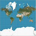
Mercator projection (redirect from Mercator map projection)
marine charts, occasional world maps, and Web mapping services, but commercial atlases have largely abandoned it, and wall maps of the world can be found in...
49 KB (6,858 words) - 10:56, 5 June 2025
Geospatial Consortium Web Feature Service standard, and also implements the Web Map Service, Web Coverage Service and Web Processing Service specifications....
6 KB (563 words) - 00:54, 21 December 2024
Mapnik (category Web Map Services)
OpenStreetMap project (OSM), which uses it in combination with an Apache Web Server module (mod_tile) and openstreetmap-carto style to render tiles that make...
4 KB (336 words) - 07:25, 21 July 2024