
Radio navigation or radionavigation is the application of radio waves to determine a position of an object on the Earth, either the vessel or an obstruction...
40 KB (5,315 words) - 22:23, 16 January 2025

transmitted along a line of sight by radio from satellites. The system can be used for providing position, navigation or for tracking the position of something...
45 KB (4,560 words) - 11:19, 28 May 2025

The field of navigation includes four general categories: land navigation, marine navigation, aeronautic navigation, and space navigation. It is also the...
83 KB (9,369 words) - 14:32, 23 May 2025

a radio receiver; this is the fundamental principle of radio communication. In addition to communication, radio is used for radar, radio navigation, remote...
163 KB (16,284 words) - 21:27, 29 May 2025

written GEE, was a radio-navigation system used by the Royal Air Force during World War II. It measured the time delay between two radio signals to produce...
53 KB (7,603 words) - 20:11, 13 February 2025

Hyperbolic navigation is a class of radio navigation systems in which a navigation receiver instrument is used to determine location based on the difference...
38 KB (5,303 words) - 23:05, 31 August 2024

In navigation, a radio beacon or radiobeacon is a kind of beacon, a device that marks a fixed location and allows direction-finding equipment to find...
13 KB (1,441 words) - 15:22, 24 September 2024
Battle of the Beams (redirect from Knickebein (navigation))
Force (Luftwaffe) used a number of increasingly accurate systems of radio navigation for night bombing in the United Kingdom. British scientific intelligence...
30 KB (4,306 words) - 22:20, 19 April 2025

Alpha, also known as RSDN-20, is a Russian system for long range radio navigation. RSDN in Russian stands for Радиотехническая Система Дальней Навигации...
3 KB (426 words) - 18:55, 10 April 2025

Area navigation (RNAV, usually pronounced as /ˈɑːrnæv/) is a method of instrument flight rules (IFR) navigation that allows aircraft to fly along a desired...
11 KB (1,326 words) - 09:50, 14 February 2025

global-range radio navigation system, operated by the United States in cooperation with six partner nations. It was a hyperbolic navigation system, enabling...
22 KB (2,818 words) - 08:37, 13 April 2025

Non-directional beacon (redirect from Radio navigation beacon)
aviation or marine navigational aid. NDB are in contrast to directional radio beacons and other navigational aids, such as low-frequency radio range, VHF omnidirectional...
26 KB (3,271 words) - 18:05, 11 January 2025
latter case, the pilot will navigate exclusively using instruments and radio navigation aids such as beacons, or as directed under radar control by air traffic...
21 KB (3,087 words) - 22:23, 29 March 2025

aircraft used commercial AM radio stations for navigation, AM stations are still marked on U.S. aviation charts. Radio navigation played an important role...
73 KB (8,479 words) - 11:53, 20 May 2025

telecommunication towers in a distance of 33 m (36 yd) Frequency for radio navigation system Frequency for radio teleswitch system Frequency for AM-broadcasting and requiring...
49 KB (3,083 words) - 09:50, 27 May 2025
Equipment codes (section Radio communication, navigation and approach aid equipment and capabilities)
to the aircraft type code. A single letter is used to represent a radio navigational capability and transponder combination. On the ICAO flight plan form...
8 KB (1,003 words) - 23:28, 16 October 2024

BeiDou (redirect from Compass navigation system)
The BeiDou Navigation Satellite System (BDS; Chinese: 北斗卫星导航系统; pinyin: běidǒu wèixīng dǎoháng xìtǒng) is a satellite-based radio navigation system owned...
67 KB (5,855 words) - 03:24, 17 April 2025

and radio navigation systems, communications satellites, wireless computer networks and many other applications. Different frequencies of radio waves...
38 KB (4,084 words) - 19:52, 11 May 2025
Methods of electronic navigation include: Satellite navigation, satellite navigation systems Radio navigation, the application of radio frequencies to determine...
618 bytes (102 words) - 18:10, 20 January 2025
Global Positioning System (redirect from Navigation Signal Timing and Ranging Global Positioning System)
hyperbolic navigation system owned by the United States Space Force and operated by Mission Delta 31. It is one of the global navigation satellite systems...
185 KB (19,119 words) - 09:36, 27 May 2025
systems. Navigation systems using sonar have also been developed. Robots can also determine their positions using radio navigation. Electronic navigation Location...
9 KB (909 words) - 04:20, 5 January 2025

information from a VOR-only station. The TACAN navigation system is an evolution of radio transponder navigation systems that date back to the British Oboe...
15 KB (1,693 words) - 18:59, 20 May 2025

Celestial navigation, also known as astronavigation, is the practice of position fixing using stars and other celestial bodies that enables a navigator...
39 KB (5,086 words) - 03:38, 8 May 2025

The Radio Navigational Aids (Publication 117) publication contains a detailed list of selected worldwide radio stations that provide services to the mariner...
3 KB (246 words) - 21:45, 15 June 2023
Direction finding (redirect from Radio direction finder)
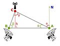
of a radio source can be determined by measuring its direction from two or more locations. Radio direction finding is used in radio navigation for ships...
73 KB (10,458 words) - 15:02, 8 May 2025
look identical) as Navigation Plus. Those units are technically known as RNS-C/RNS-D and RNS-E, where RNS stands for "Radio Navigation System". The RNS-C...
8 KB (1,009 words) - 16:01, 6 January 2025

VHF omnidirectional range (redirect from VHF Omni-directional Radio Range)
Frequency Omnidirectional Range Station (VOR) is a type of short-range VHF radio navigation system for aircraft, enabling aircraft with a VOR receiver to determine...
53 KB (6,919 words) - 09:32, 11 March 2025

Automatic direction finder (redirect from Radio-magnetic indicator)
aircraft radio-navigation instrument that automatically and continuously displays the relative bearing from the ship or aircraft to a suitable radio station...
11 KB (1,379 words) - 17:08, 19 April 2025
LORAN (redirect from Loomis radio navigation)
LORAN (Long Range Navigation) was a hyperbolic radio navigation system developed in the United States during World War II. It was similar to the UK's...
40 KB (5,780 words) - 12:16, 23 April 2025

the main United Kingdom research and development organisation for radio navigation, radar, infra-red detection for heat seeking missiles, and related...
33 KB (4,299 words) - 11:13, 9 January 2025