
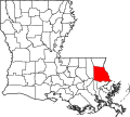
St. Tammany Parish (French: Paroisse de Saint-Tammany; Spanish: Parroquia de St. Tammany) is a parish located in the U.S. state of Louisiana named after...
35 KB (3,137 words) - 11:08, 28 May 2024

Mandeville is a city in St. Tammany Parish, Louisiana, United States. Its population was 13,192 at the 2020 United States census. Mandeville is located...
27 KB (2,348 words) - 00:43, 29 May 2024
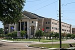
Covington is a city in, and the parish seat of, St. Tammany Parish, Louisiana, United States. The population was 11,564 at the 2020 United States census...
24 KB (1,732 words) - 20:30, 10 May 2024
Madisonville is a town in St. Tammany Parish in the U.S. state of Louisiana. The population was 748 at the 2010 U.S. census, and 850 at the 2020 U.S....
20 KB (1,463 words) - 03:16, 16 May 2024

Folsom is a village in St. Tammany Parish, Louisiana, United States. The population was 716 at the 2010 census, and 769 in 2020. The town is named after...
9 KB (687 words) - 03:12, 16 May 2024

St. Tammany Parish Public Schools is a public school district serving the children of St. Tammany Parish, located along the Northshore banks of Lake Pontchartrain...
13 KB (636 words) - 22:17, 23 May 2024

Lacombe is a census-designated place (CDP) in St. Tammany Parish, Louisiana, United States. The population was 8,679 at the 2010 census, and 8,657 in...
11 KB (651 words) - 12:39, 15 May 2024

Abita Springs is a town in St. Tammany Parish, Louisiana, United States. The population was 2,365 at the 2010 census, up from 1,957 in 2000. It is part...
13 KB (971 words) - 03:16, 16 May 2024

Sun is a village in the northeastern corner of St. Tammany Parish, Louisiana, United States. The population was 470 at the 2010 census, and 392 in 2020...
9 KB (575 words) - 03:12, 16 May 2024

Pearl River is a town in St. Tammany Parish in the U.S. state of Louisiana. The population was 2,506 at the 2010 U.S. census, and 2,618 at the 2020 population...
16 KB (957 words) - 03:14, 16 May 2024
Eden Isle is a census-designated place (CDP) in St. Tammany Parish, Louisiana, United States, on the northeast shore of Lake Pontchartrain. The population...
8 KB (463 words) - 14:42, 15 May 2024
unincorporated community in northeastern St. Tammany Parish, Louisiana, United States. Bush is on Louisiana Highway 21 south of Sun connecting to Bogalusa...
5 KB (224 words) - 05:16, 3 May 2024

/slaɪˈdɛl/ is a city on the northeast shore of Lake Pontchartrain in St. Tammany Parish, Louisiana, United States. The population was 28,781 at the 2020 census...
37 KB (2,449 words) - 13:57, 20 April 2024
community in St. Tammany Parish, Louisiana, United States. The community is located 8 mi (13 km) north of Slidell at the intersection of Louisiana Highway...
3 KB (58 words) - 05:16, 3 May 2024

Lake Pontchartrain (redirect from North Shore, Louisiana)
the lake is located in parts of six Louisiana parishes: St. Tammany, Orleans, Jefferson, St. John the Baptist, St. Charles, and Tangipahoa. The water...
33 KB (3,615 words) - 23:10, 20 February 2024
south of Folsom, St. Tammany Parish. KML file (edit • help) Template:Attached KML/Louisiana Highway 1078 KML is not from Wikidata Louisiana Highway 1078 (LA 1078)...
75 KB (5,495 words) - 19:41, 28 November 2023
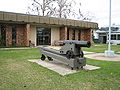
The St. Tammany Parish Sheriff's Office (STPSO) is the chief law enforcement agency of St. Tammany Parish, Louisiana. It falls under the authority of the...
9 KB (619 words) - 00:17, 12 February 2024
St. Tammany Regional Airport (FAA LID: L31) is a public use airport in St. Tammany Parish, Louisiana, United States. It is owned by St. Tammany Parish...
3 KB (263 words) - 00:24, 4 January 2024
School is a public high school in Covington, Louisiana, United States. It is one of the Saint Tammany Parish Public Schools. The school serves residents...
8 KB (552 words) - 02:13, 29 April 2024
grades nine through twelve located in Slidell, Louisiana, United States. It is part of the St. Tammany Parish Public School District and serves portions of...
5 KB (213 words) - 04:34, 10 January 2024

Louisiana Highway 59 (LA 59) is a state highway located in St. Tammany Parish, Louisiana. It runs 11.74 miles (18.89 km) in a north–south direction from...
12 KB (1,450 words) - 01:59, 16 February 2024

Interstate 12 (redirect from Interstate 12 (Louisiana))
serves the cities of Ponchatoula and Denham Springs, as well as the St. Tammany Parish cities of Covington and Mandeville. I-12 parallels the older US 190...
22 KB (1,641 words) - 23:41, 19 January 2024

New Orleans–Metairie–Slidell combined statistical area (redirect from New Orleans-Metairie-Bogalusa, Louisiana combined statistical area)
Katrina on August 29, 2005. Louisiana Jefferson Orleans Plaquemines St. Bernard St. Charles St. James St. John the Baptist St. Tammany Washington Mississippi...
7 KB (320 words) - 00:50, 23 April 2024

of Jefferson Parish flowing generally in a north-west to south-east direction. Surrounding parishes include St. Tammany Parish, Louisiana at the north...
54 KB (5,347 words) - 08:45, 4 May 2024

St. Bernard Parish (French: Paroisse de Saint-Bernard; Spanish: Parroquia de San Bernardo) is a parish in the U.S. state of Louisiana. The parish seat...
32 KB (2,885 words) - 06:41, 26 May 2024

unincorporated community in St. Tammany Parish, Louisiana, United States. Its ZIP code is 70457. The Roman Catholic abbey and seminary St. Joseph Abbey is in...
3 KB (91 words) - 05:16, 3 May 2024

Louisiana Highway 41 (LA 41) is a state highway located in St. Tammany Parish, Louisiana. It runs 23.07 miles (37.13 km) in a north–south direction from...
16 KB (1,876 words) - 01:58, 16 February 2024

in the 1955 Louisiana Highway renumbering, giving a single route number to the east–west corridor in Tangipahoa and St. Tammany parishes between LA 16...
18 KB (1,925 words) - 01:58, 16 February 2024
congressional district, dropping its precincts south of the lake and adding St. Tammany Parish, which borders Lake Pontchartrain on the north, from the 6th congressional...
47 KB (819 words) - 01:29, 7 May 2024
New Orleans metropolitan area (redirect from Westbank, Louisiana)
The eight parishes covered by the commission are: Jefferson, Orleans, Plaquemines, St. Bernard, St. Charles, St. John the Baptist, St. Tammany and Tangipahoa...
43 KB (3,093 words) - 05:08, 16 May 2024