Geological structure measurement by LiDAR technology is a remote sensing method applied in structural geology. It enables monitoring and characterisation...
53 KB (5,200 words) - 06:26, 30 June 2025

alternative to lidar for close range applications. Geological structure measurement by LiDAR – Terrain measurement with light beams Lidar detector – Used...
133 KB (15,040 words) - 19:20, 14 July 2025

different specialized magnetic compasses used by geologists to measure orientation of geological structures, as they map in the field, to analyze and document...
8 KB (1,020 words) - 20:35, 12 February 2025

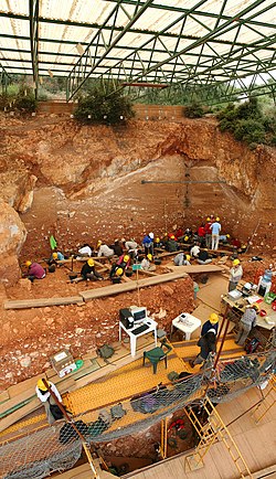
used in the geological sciences as a data acquisition method complementary to field observation, because it allows mapping of geological characteristics...
63 KB (7,134 words) - 14:51, 8 June 2025

stereoplotter has been replaced by more modern photogrammetric methods, digital and automated, as in the case of structure from motion. Lidar (light radar) has also...
9 KB (1,351 words) - 20:49, 16 February 2021

Photogrammetry (category Articles covered by WikiProject Wikify from June 2019)
z direction [citation needed]. This range data can be supplied by techniques like LiDAR, laser scanners (using time of flight, triangulation or interferometry)...
31 KB (3,236 words) - 18:32, 25 May 2025

Underwater exploration (section Direct measurements)
investigation of the geological characteristics of the seabed and freshwater equivalents, and investigation of the geological structure, strata, and sediments...
44 KB (5,336 words) - 06:36, 7 May 2025

Underwater survey (section Geological surveys)
looking over and detailed study of a subject. One meaning is the accurate measurement of a geographical region, usually to plot the positions of features as...
32 KB (4,061 words) - 20:37, 13 March 2025

Elevation Data 2010 (GMTED2010) by the U.S. Geological Survey Earth2014 by Technische Universität München Sonny's LiDAR Digital Terrain Models of Europe...
32 KB (3,353 words) - 18:13, 5 July 2025

Carolina bays (category Geology of the United States)
Plain Uplands of North and South Carolina Revealed by High-Resolution LiDAR Data. PDF version Geological Society of America Abstracts with Programs. v. 43...
46 KB (5,665 words) - 17:31, 15 June 2025

Dataset (PDF). U.S. Geological Survey. 2009. Maceyka, Andy; Hansen, William F (2016). "Enhancing hydrologic mapping using LIDAR and high resolution aerial...
30 KB (3,165 words) - 02:18, 6 July 2025
EarthScope (category Regional geology)
Foundation (NSF) funded Earth science program using geological and geophysical techniques to explore the structure and evolution of the North American continent...
35 KB (4,457 words) - 10:36, 12 June 2025
Isotopes of lithium (redirect from Li-4)
(16 August 2013). "Density distributions of 11 Li deduced from reaction cross-section measurements". Physical Review C. 88 (2): 024610. Bibcode:2013PhRvC...
27 KB (3,260 words) - 10:49, 14 June 2025

Digital outcrop model (category Geological techniques)
for interpretation and reproducible measurement of different geological features, e.g. orientation of geological surfaces, width and thickness of layers...
16 KB (1,883 words) - 17:17, 1 April 2025

Subsidence (category Depressions (geology))
Satellite System (GNSS) Interferometric Synthetic Aperture Radar (InSAR) LiDAR Tiltmeters. Tomás et al. conducted a comparative analysis of various land...
56 KB (5,735 words) - 13:45, 12 July 2025

sensors attached to a platform. Sensors include cameras, digital scanners and lidar, while platforms usually consist of aircraft and satellites. In England...
103 KB (13,345 words) - 00:48, 13 July 2025

Radar (redirect from Radar distance measurement)
make use of other parts of the electromagnetic spectrum. One example is lidar, which uses predominantly infrared light from lasers rather than radio waves...
103 KB (12,058 words) - 09:42, 23 June 2025

concurrent deployment of both a polarimeter and Lidar instrument from an airplane (airborne measurements). The survey recommended intentional, early development...
20 KB (1,992 words) - 02:50, 10 January 2025
particle sensor, electromagnetic & sonic wave measurement of dust, and short range LIDAR. Geology Geological description of the landing site including interior...
11 KB (728 words) - 12:04, 1 June 2024

Gravity of Mars (section Measurement)
be further assisted by employment of LIDAR on site in determining the exact landing position and other protective measures. Geology of Mars Mars carbonate...
53 KB (6,282 words) - 00:06, 9 April 2025
airborne photography and performs aerial LiDAR observations of the sites being studied. This is accomplished by slow flying aircraft surveying at 1,000...
26 KB (2,389 words) - 01:59, 25 January 2025

Tiwanaku (category Buildings and structures in La Paz Department (Bolivia))
surveillance methods were used by UNESCO to create an aerial picture of the site. Lidar, aerial photography, drones, and terrestrial laser scanning were all used...
43 KB (4,988 words) - 17:26, 24 June 2025

Phoenix (spacecraft) (category Spacecraft launched by Delta II rockets)
atmosphere, a lidar was employed. The lidar collected information about the time-dependent structure of the planetary boundary layer by investigating...
119 KB (11,707 words) - 23:22, 21 May 2025
Spectroradiometry for Earth and planetary remote sensing (category Geological techniques)
volcanic materials from hyperspectral field and satellite data compared with LiDAR data at Mt. Etna". International Journal of Applied Earth Observation and...
72 KB (6,353 words) - 23:42, 3 June 2025

Unmanned aerial vehicle (section Geological hazards)
as: RGB, multispectral, hyper-spectral cameras or LiDAR, which may allow providing specific measurements or observations. UAV actuators include digital electronic...
161 KB (15,102 words) - 05:23, 23 June 2025


Sea level rise (redirect from Measurement of sea levels)
under warming of 3 °C (5.4 °F). This is close to the current trajectory. LiDAR-based research had established in 2021 that 267 million people worldwide...
214 KB (22,607 words) - 04:30, 9 July 2025

large-scale monitoring. LiDAR (Light Detection and Ranging): Provides detailed 3D models of terrain to detect changes over time by comparison of different...
65 KB (7,371 words) - 13:56, 30 May 2025
active remote sensing instruments: Lidar: Lidar (light detection and ranging) uses a laser (light amplification by stimulated emission of radiation) to...
134 KB (14,043 words) - 19:47, 11 July 2025
