
The Absaroka Range is a sub-range of the Rocky Mountains in the United States. The range stretches about 150 mi (240 km) across the Montana–Wyoming border...
12 KB (813 words) - 22:14, 3 June 2025

Bighorn Mountains (redirect from Bighorn Range)
(320 km) northward on the Great Plains. They are separated from the Absaroka Range, which lie on the main branch of the Rockies to the west, by the Bighorn...
21 KB (2,605 words) - 10:36, 8 June 2025

Rocky Mountains. The summit of Francs Peak is the highest point of the Absaroka Range. The summit of Twilight Peak is the highest point of the West Needle...
166 KB (13,957 words) - 05:18, 17 July 2025

Montana, and dominates the northwest corner of the park. The Absaroka Range, the largest range in the park, begins approximately 80 miles (130 km) north...
18 KB (3,965 words) - 05:05, 17 July 2025

Park in Park County. The valley is flanked by the Absaroka Range on the east and the Gallatin Range on the west. The Paradise Valley is separated from...
5 KB (448 words) - 20:46, 18 January 2025
SS Absaroka was a steamer, named after the Absaroka Range of mountains in Montana and Wyoming, completed in February 1918 for the United States Shipping...
15 KB (1,384 words) - 10:00, 6 May 2025

44°N 107°W / 44°N 107°W / 44; -107 Absaroka was a proposed state in the United States that would have comprised parts of the states of Montana, South...
18 KB (1,930 words) - 17:05, 23 November 2024

and Canada Absaroka Range, Montana and Wyoming Beartooth Mountains, Montana and Wyoming Bighorn Mountains, Montana and Wyoming Bitterroot Range, Montana...
54 KB (4,887 words) - 00:56, 26 July 2025

655 feet (2,943 m) above sea level. On the Continental Divide in the Absaroka Range of northwestern Wyoming in Teton County, it is between Dubois and Moran...
10 KB (483 words) - 22:07, 14 March 2025

Eagle Peak is a mountain in the Absaroka Range in the U.S. state of Wyoming and at 11,372 feet (3,466 m) is the highest point in Yellowstone National Park...
10 KB (1,047 words) - 17:43, 25 June 2025

Owl Creek Mountains (redirect from Owl Creek Range)
west to form a bridge between the Absaroka Range to the northwest and the Bridger Mountains to the east. The range forms the boundary between the Bighorn...
3 KB (339 words) - 20:14, 12 July 2025

Valley, north of the Absaroka Range of Mountains. The Crows continued a largely nomadic life style hunting on the buffalo ranges to the east, though this...
19 KB (2,077 words) - 23:42, 12 July 2025

distinct mountain ranges: the Beartooth and Absaroka ranges. These ranges are completely distinct geologically speaking, with the Absaroka composed primarily...
11 KB (1,120 words) - 05:45, 28 June 2025

caused uplift of the Beartooth Range and subsidence of the Bighorn and Absaroka Basins. Just south of the Beartooth Range, this orogeny uplifted an elongate...
8 KB (912 words) - 18:52, 28 June 2025
1939 Absaroka Range, a sub-range of the Rocky Mountains stretching across Montana and Wyoming in the northwestern United States Absaroke or Absaroka, a...
874 bytes (142 words) - 15:03, 4 November 2019

Isawaxaawúua), Wolf Mountains (Cheetiish, or "Wolf Teeth Mountains") and Absaroka Range (also called Absalaga Mountains). Once established in the Valley of...
77 KB (10,218 words) - 06:35, 7 July 2025

indented below the name of the primary range. Some of these ranges extend into Wyoming, Idaho, and Canada. Absaroka Range; Park County, Montana; 43°57′40″N...
25 KB (5,073 words) - 05:04, 17 July 2025

Uinta Mountains (redirect from Uinta Range)
Uinta Mountains (/juːˈɪntə/ yoo-IN-tə) are an east-west trending mountain range in northeastern Utah extending a short distance into northwest Colorado...
14 KB (1,525 words) - 04:37, 23 July 2025
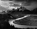
The Teton Range is a mountain range of the Rocky Mountains in North America. It extends for approximately 40 miles (64 km) in a north–south direction...
8 KB (810 words) - 23:34, 3 August 2025

river flows northward into Montana between the northern Absaroka Range and the Gallatin Range in Paradise Valley. The river emerges from the mountains...
48 KB (4,416 words) - 00:48, 16 July 2025
Rocky Mountains. The summit of Francs Peak is the highest point of the Absaroka Range. The summit of Twilight Peak is the highest point of the West Needle...
114 KB (9,527 words) - 19:12, 29 June 2025
Walt Longmire (redirect from Absaroka County)
the county seat of fictional Absaroka County, named after the real-life Absaroka Native Americans, the Absaroka Range, and the 1930s effort to declare...
25 KB (3,250 words) - 02:50, 11 May 2025

296. The pass is located on Chief Joseph Scenic Byway and crosses the Absaroka Range. Dead Indian Creek runs at the base of the pass. Near the pass are also...
6 KB (690 words) - 21:29, 29 July 2025

feet (3,330 m) is a prominent mountain peak on the western edge of the Absaroka Range near Emigrant, Montana. The peak is flanked by Emigrant Gulch on the...
2 KB (129 words) - 09:56, 5 January 2025

River Basin, and includes portions of the Wind River Range, Owl Creek Mountains, and Absaroka Range. The Wind River Indian Reservation is the seventh-largest...
60 KB (7,028 words) - 02:39, 29 May 2025

below the name of the primary range. Some of these ranges extend into Colorado, Montana, Idaho, and Utah. Absaroka Range, Park County, Wyoming, 43°57′40″N...
25 KB (5,401 words) - 05:04, 17 July 2025

peoples of the Great Basin, such as the Shoshones and Absarokas (Crow) Native Americans, lived in the range beginning 7000 and 9000 years ago. Villages as high...
19 KB (2,042 words) - 17:00, 15 July 2025
Traversed by North Two Ocean Creek Location Teton County, Wyoming Range Absaroka Range Coordinates 44°02′33″N 110°10′30″W / 44.04250°N 110.17500°W /...
7 KB (632 words) - 22:23, 1 June 2025
mountain peak in the Absaroka Range near Livingston, Montana. The peak is located within the Gallatin National Forest and the Absaroka-Beartooth Wilderness...
1 KB (48 words) - 10:02, 5 January 2025

Rocky Mountains. The summit of Francs Peak is the highest point of the Absaroka Range. The summit of Lizard Head Peak is the highest point of the Cirque of...
46 KB (3,446 words) - 10:01, 5 January 2025