
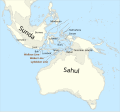
The Barat Daya Islands (Indonesian: Kepulauan Barat Daya) are a group of islands in the Maluku province of Indonesia. The Indonesian phrase barat daya means...
11 KB (768 words) - 06:10, 25 April 2024

Lesser Sunda Islands are, from west to east: Bali, Lombok, Sumbawa, Flores, Sumba, Savu, Rote, Timor, Atauro, Alor archipelago, Barat Daya Islands, and Tanimbar...
16 KB (1,743 words) - 22:18, 13 June 2024
(Indonesian: Pulau Damer), also called Kenli Island, is a small volcanic island in the Barat Daya Islands group in Indonesia's Maluku province, on the...
3 KB (304 words) - 09:18, 1 April 2024

Rote Timor Alor Archipelago Atauro Barat Daya Islands Tanimbar Islands Banda Arc Komodo (island) List of islands of Indonesia Malay Archipelago Nusantara...
3 KB (261 words) - 03:12, 1 February 2024

Romang is an island, part of the Barat Daya Islands in Indonesia, located at 7°35′00″S 127°26′00″E / 7.5833333°S 127.4333333°E / -7.5833333; 127.4333333...
2 KB (170 words) - 10:45, 1 April 2024
Wetar (redirect from Wetar Island)
tropical island which belongs to the Indonesian province of Maluku and is the largest island of the Maluku Barat Daya Islands (literally Southwest Islands) Regency...
7 KB (694 words) - 10:05, 1 April 2024
Liran (category Barat Daya Islands)
(Kabupaten Maluku Barat Daya). The East Timorese island Atauro is 12 km to the southwest. Liran is the westernmost of the Barat Daya Islands in the province...
2 KB (165 words) - 04:02, 11 March 2023

Trangan Wokam Babar Banda Barat Daya Islands Damer Liran Romang Wetar Boano Buru Gorong archipelago Kai Islands Kelang Leti Islands Lakor Leti Moa Manipa...
16 KB (1,016 words) - 08:13, 21 April 2024
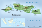
islands, Letti, Moa and Lakor; each of the three islands now constitutes a separate administrative district (kecamatan) within the Maluku Barat Daya Regency...
4 KB (402 words) - 06:25, 25 April 2024

Islands, Kai Islands, and the Barat Daya Islands except for Wetar. The islands in the ecoregion are part of Wallacea, a group of indonesian islands which...
8 KB (881 words) - 21:06, 11 May 2024
Barat Daya Regency of Maluku province. Tepa (a town with a population of about 2,000 people) is the administrative center of the former Babar Islands...
7 KB (911 words) - 09:05, 1 April 2024
located at the south of Strait of Manipa near Ceram. To the west is Lucipara Islands, to the east is Banda Islands and the south Barat Daya Islands. v t e...
388 bytes (56 words) - 22:15, 20 April 2020
Maluku Islands Sunda Islands Greater Sunda Islands Borneo Java Sulawesi Sumatra Lesser Sunda Islands Alor Archipelago Bali Barat Daya Islands Flores Komodo...
34 KB (3,046 words) - 22:37, 3 June 2024
Nyata (redirect from Nyata island)
Nyata is an island in the Barat Daya Islands in the Banda Sea. It is northwest of Romang, in the Banda Sea. Nyata at GEOnet Names Server 07°31′14″S 127°17′19″E...
437 bytes (51 words) - 22:36, 25 April 2022

Mount Nila (category Barat Daya Islands)
volcano forms completely an isolated 5 × 6 km wide of island with the same name in the Barat Daya Islands of the Banda Sea, Indonesia. The volcano comprises...
1 KB (101 words) - 22:54, 22 May 2024

Southwest Papua (redirect from Papua barat daya)
Southwest Papua (Indonesian: Papua Barat Daya) is the 38th province of Indonesia to be created, and was split off from West Papua on 8 December 2022. Despite...
56 KB (5,520 words) - 15:09, 14 June 2024
Kisar (redirect from Kisar Island)
geochemistry all indicate that the island belongs geologically with the other islands of the Outer Banda Arc. This series of islands formed when the northern edge...
12 KB (1,318 words) - 09:57, 1 April 2024
and Barat Daya Islands (except for Wetar) in the southeastern Banda Sea form the Banda Sea Islands moist deciduous forests ecoregion. These islands are...
15 KB (1,515 words) - 00:33, 2 January 2024

Tenggara Barat). On 24 June 2008 the western districts of this Regency were split off to create the Southwest Maluku Regency (Kabupaten Maluku Barat Daya), leaving...
8 KB (420 words) - 04:12, 2 June 2024
forests: Banda Sea Islands moist deciduous forests (Kai Islands, Tanimbar Islands, Babar Islands, Leti Islands, eastern Barat Daya Islands) Buru rain forests...
15 KB (1,539 words) - 06:56, 12 June 2024
Mount Serua (redirect from Serua Island)
Serua is a volcanic island located in the Banda Sea, Indonesia. Administratively it is part of the Maluku Tengah Regency, Maluku Province. The main village...
2 KB (103 words) - 03:03, 4 December 2023
List of archipelagos (category Lists of islands)
Islands Barat Daya Islands Babar Islands Boo Islands Derawan Islands Erà Islands Gili Islands Gorong Archipelago Hinako Islands Kangean Islands Karakaralong...
32 KB (2,638 words) - 20:44, 30 May 2024

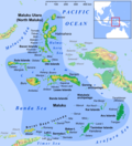
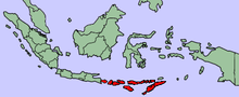
Southwest Maluku Regency (redirect from Maluku Barat Daya)
Kabupaten Maluku Barat Daya) is a regency of Maluku Province, Indonesia. Geographically it forms the most eastern portion of the Lesser Sunda Islands, although...
12 KB (626 words) - 04:16, 2 June 2024
Manuk (category Barat Daya Islands)
Manuk is an uninhabited volcanic island located in the Banda Sea, Indonesia. Administratively it is part of the Maluku Tengah Regency, Maluku Province...
2 KB (95 words) - 15:11, 13 November 2023

Maluku (province) (category Maluku Islands)
Lease Islands (Kepulauan Lease) includes Saparua, Nusa Laut and Haruku Islands Seram Southwestern Islands (Barat Daya Islands) includes Wetar Island, Kisar...
50 KB (5,341 words) - 15:12, 2 April 2024

in an area that ranges from Rote Island across Timor and the Barat Daya Islands to Selaru (one of the Tanimbar Islands). This comparison table (a small...
8 KB (620 words) - 20:48, 1 May 2024
Maluku Barat Daya" (in Indonesian). December 17, 2021. "M 6.0 - South Sandwich Islands region". earthquake.usgs.gov. "M 6.0 - Prince Edward Islands region"...
258 KB (11,959 words) - 22:47, 9 June 2024
Flores, Sumba, Timor, Alor archipelago, Barat Daya Islands, and Tanimbar Islands. This list is arranged by island in alphabetical order. The respective...
2 KB (181 words) - 11:42, 5 February 2024
Mdona Hyera (category Barat Daya Islands)
The Sermata Islands or Sematang Islands (formerly called Mdona Hyera), is a small group of islands within the Southwest Maluku Regency, part of Maluku...
2 KB (238 words) - 10:44, 1 April 2024

List of rivers of East Nusa Tenggara (category Rivers of Lesser Sunda Islands)
Sunda Islands. The main islands in the province are, from west to east: Flores, Sumba, Timor, Alor Archipelago, Barat Daya Islands, and Tanimbar Islands. Benanain...
2 KB (187 words) - 11:47, 5 February 2024