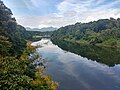
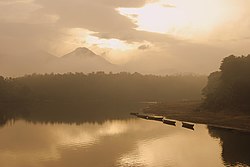
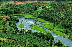
Chaliyar River (Malayalam: [tʃaːlijaːr]) is the fourth longest river in Kerala at 169 km in length. The Chaliyar is also known as Chulika River, Nilambur...
13 KB (1,034 words) - 08:28, 2 March 2025

located close to the Nilgiris range of the Western Ghats on the banks of the Chaliyar River. This place is also known as 'Teak Town' because of the abundance...
19 KB (1,681 words) - 09:49, 3 July 2025

district of India. The district has four major rivers, namely Bharathappuzha, Chaliyar, Kadalundippuzha, and Tirur Puzha, out of which the first three are also...
241 KB (19,100 words) - 19:15, 14 July 2025

Panchayat of Nilambur Taluk, Malappuram District, Kerala, India bordering Chaliyar and Koodaranji Grama Panchayats of Kozhikode district. Kakkadampoyil is...
4 KB (437 words) - 16:48, 4 June 2025
when India separated from the African continent. The Iruvanjippuzha and Chaliyar rivers, both originating in the Western Ghats, flow westward towards the...
164 KB (12,999 words) - 14:47, 30 July 2025
River Chaliyar Kondotty Taluk, Malappuram District, State of Kerala, India. East and some north part of Vazhakkad bordering with River Chaliyar, South...
5 KB (367 words) - 00:28, 17 April 2025
K. A. Rahman (redirect from Legend of the Chaliyar)
popularly known as Adhrehyaka or simply Adreyi, was the founder leader of the Chaliyar agitation in Kerala, India. Adreyi was the third son of Kavungal Kunhoyi...
5 KB (621 words) - 23:44, 17 April 2025

at the estuary of Chaliyar (River Beypore) in Kozhikode district of Kerala, India. Chaliyam forms an island, bounded by the Chaliyar in the north, and...
15 KB (1,517 words) - 23:22, 23 February 2025

William Denison. Denison barb is endemic to the Achenkovil, Pamba and Chaliyar rivers. Specifically, they are found in four locations — Cheenkannipuzha...
10 KB (1,063 words) - 09:21, 15 July 2025

shore of the river Chaliyar. Many farmers belong to Edavannappara and they depend mainly on the water from Chaliyar. So Chaliyar is known as the vein...
8 KB (606 words) - 02:04, 14 July 2025
Taluk under British Malabar District was the land between two rivers, Chaliyar and Kadalundi River. On west it was bound by the Nilgiri Mountains. It...
19 KB (1,836 words) - 09:58, 1 July 2025

important rivers from north to south are the Valapattanam 110 km (68 mi), Chaliyar 169 km (105 mi), Kadalundipuzha 130 km (81 mi), Bharathappuzha 209 km (130 mi)...
29 KB (3,164 words) - 11:14, 25 June 2025
Areekode is a town on the banks of the Chaliyar River in Areekode Grama Panchayat in Malappuram district, India. It was part of the Malabar district in...
6 KB (398 words) - 16:26, 12 May 2025

or Iruvanjipuzha, is a major tributary of River Chaliyar flowing in Kerala. It joins into Chaliyar at Koolimadu near Cheruvadi. Its major tributary is...
5 KB (296 words) - 20:40, 15 June 2025
in Kerala. The eastern regions in the districts of Wayanad, Malappuram (Chaliyar valley at Nilambur), and Palakkad (Attappadi Valley), which together form...
293 KB (26,998 words) - 09:34, 1 August 2025
Bharathapuzha; 209 kilometres (130 mi), Pamba; 176 kilometres (109 mi), Chaliyar; 169 kilometres (105 mi), Kadalundipuzha; 130 kilometres (81 mi), Chalakudipuzha;...
14 KB (1,162 words) - 14:04, 31 May 2025
India. Attappadi valley in Palakkad district along with the neighbouring Chaliyar valley of the Nilambur region (Eastern Eranad region) in Malappuram district...
23 KB (2,409 words) - 18:31, 15 June 2025
In Kerala State of India. Kizhuparamba is situated on the banks of the Chaliyar River and on the border of Malappuram and Kozhikode districts. Kizhuparamba...
9 KB (764 words) - 05:17, 10 May 2025

Munderi, Malappuram (section Chaliyar River)
forests lead to Chooralmala (near Meppadi) in Wayanad district. River Chaliyar originates from the Elampalari Hills, which is located near the meeting...
6 KB (414 words) - 12:54, 22 November 2024

Kaveri River, originates at Wayanad. Wayanad district, along with the Chaliyar valley in the neighbouring Nilambur (Eastern Eranad region) in Malappuram...
73 KB (7,048 words) - 15:41, 10 July 2025

means "field".) Mavoor is located 21 km east of Kozhikode city, beside the Chaliyar River. Until the 1960s, Mavoor was like any other village in Kerala. During...
9 KB (839 words) - 09:34, 24 May 2025
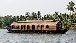
India. It is located opposite to Chaliyam, the estuary where the river Chaliyar empties into the Arabian Sea. Beypore is part of Kozhikode Municipal Corporation...
18 KB (2,041 words) - 11:40, 17 May 2025

Arabs chose Beypore for construction of dhows, as there was a port and Chaliyar has deep waters. With the arrival of modern transport methods, Uru construction...
6 KB (724 words) - 13:57, 20 January 2025

Government Primary Health Centre, Mampad Hi Care Clinic Rahmath Hospital Chaliyar Asif Saheer-Indian former football player MAMPAD RAHMAN Former national...
5 KB (362 words) - 14:25, 26 June 2025

of 45 metres (148 ft) and is 22 km (13.7 mi) long. It is linked to the Chaliyar by a man-made canal on the south side of the small timber village of Kallayi...
2 KB (158 words) - 04:13, 26 April 2025

northern bank of Chaliyar, became Northern Parappanad. Kadalundi, Vallikkunnu, and Parappanangadi, on the southern bank of Chaliyar became Southern Parappanad...
14 KB (853 words) - 16:48, 1 August 2025

the banks of Iruvanjippuzha River, one of the major tributaries of the Chaliyar River. Mukkam is under Kozhikode Taluk, Thiruvambady Assembly Constituency...
7 KB (305 words) - 02:51, 30 June 2025
is the first community reserve in Kerala. The Kadalundi River and the Chaliyar river, two of the longest rivers of Kerala, merges with the Arabian Sea...
16 KB (1,398 words) - 08:55, 5 April 2025

the Kozhikode-Nilambur-Gudalur state highway and near the banks of the Chaliyar River. The Koyilandy-Edavanna state highway ends here. Edavanna is part...
3 KB (74 words) - 08:37, 2 August 2025
Feroke was built by the British in 1883. Feroke, on the southern bank of Chaliyar river, was adjacent to the kingdom of Parappanad during medieval period...
21 KB (1,787 words) - 22:02, 10 July 2025