
Deep-ocean Assessment and Reporting of Tsunamis (DART) is a component of an enhanced tsunami warning system. By logging changes in seafloor temperature...
14 KB (1,825 words) - 11:48, 24 March 2025

the world. Deep ocean tsunami sensor detection of an event. In 1995, NOAA began developing the Deep-ocean Assessment and Reporting of Tsunamis (DART) system...
12 KB (1,198 words) - 15:38, 3 May 2025
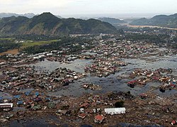
a tsunami is in deep water, it has little height and a network of sensors is needed to detect it. Tsunamis are more frequent in the Pacific Ocean than...
179 KB (19,041 words) - 07:27, 24 May 2025

ACARS (redirect from Aircraft Communication Addressing and Reporting System)
Communications Addressing and Reporting System) is a digital data communication system for transmission of short messages between aircraft and ground stations via...
16 KB (1,849 words) - 20:56, 22 May 2025

Teletsunami (redirect from Ocean-wide tsunami)
India, and Somalia. It was the first teletsunami to have extensive video evidence. Cumbre Vieja tsunami hazard Deep-ocean Assessment and Reporting of Tsunamis...
15 KB (1,763 words) - 11:41, 1 February 2025
tsunamis. The tsunami warning system has been in use since the mid-2000s. A warning system for the Indian Ocean was prompted by the 2004 Indian Ocean...
6 KB (685 words) - 00:36, 13 May 2025

developing the Deep-ocean Assessment and Reporting of Tsunamis (DART) system. By 2001, an array of six stations had been deployed in the Pacific Ocean. Beginning...
17 KB (1,508 words) - 11:08, 27 January 2025

Physical oceanography (redirect from Ocean physics)
oceanography is the study of physical conditions and physical processes within the ocean, especially the motions and physical properties of ocean waters. Physical...
36 KB (4,538 words) - 09:53, 12 May 2025
Dart (section Arts, entertainment and media)
transfer model used in remote sensing Deep-ocean Assessment and Reporting of Tsunamis, a component of an enhanced tsunami warning system Direct analysis in...
5 KB (697 words) - 12:25, 16 January 2025
gauges, eight Deep-ocean Assessment and Reporting of Tsunamis (DART) stations, eight atmospheric pressure time series, spectral analysis and computer simulation...
206 KB (18,452 words) - 14:16, 22 May 2025

tsunami arrived, giving them some time to evacuate areas likely to be affected. Oceans portal Tsunamis portal Deep-ocean Assessment and Reporting of Tsunamis...
24 KB (2,563 words) - 00:11, 12 June 2025
Weather ship (redirect from Ocean Weather Station)
primarily located in the north Atlantic and north Pacific oceans, reporting via radio. The vessels aided in search and rescue operations, supported transatlantic...
31 KB (3,627 words) - 18:22, 4 April 2025

Meteorology (redirect from Slight Risk Of Severe Thunderstorms)
with large bodies of water. Meteorologists study meteorological phenomena driven by solar radiation, Earth's rotation, ocean currents and other factors....
97 KB (10,193 words) - 19:37, 10 June 2025
Meteotsunami (redirect from Meteorological tsunami)
and three people were swept off a jetty, two seriously injured, when a six-foot wave struck the Barnegat Inlet. Deep-ocean Assessment and Reporting of...
13 KB (1,062 words) - 01:42, 21 April 2025
complement other systems, such as DART (Deep-ocean Assessment and Reporting of Tsunamis). With operating lives of 15 to 25 years, SMART cables are expected...
21 KB (2,106 words) - 00:47, 15 May 2025

Sea surface temperature (category Pages displaying short descriptions of redirect targets via Module:Annotated link)
in ocean heat content and ocean stratification. The increase of both ocean surface temperature and deeper ocean temperature is an important effect of climate...
43 KB (4,825 words) - 23:17, 8 June 2025
Global Sea Level Observing System (category Meteorological data and networks)
Global Sea Level Observing System does not compete with Deep-ocean Assessment and Reporting of Tsunamis as most GLOSS transducers are located close to land...
3 KB (392 words) - 00:25, 18 January 2024
pilots in observing and reporting weather while in flight. Reports submitted by these pilots are annotated with /AWC at the end of the remarks section.: 33 ...
11 KB (1,489 words) - 20:25, 29 December 2024

Weather balloon (category Meteorological instrumentation and equipment)
Scientists and environmentalists have raised concerns about weather balloons' environmental impact. The latex material, which can persist in the ocean for extended...
13 KB (1,306 words) - 02:08, 26 February 2025

the quality and volume of ocean data since the IPCC Fourth Assessment Report and the resulting improvement in confidence in the description of surface salinity...
24 KB (2,842 words) - 03:28, 26 April 2025
National Data Buoy Center (category National Environmental Satellite, Data, and Information Service)
Conductivity and water current are measured at selected stations. A new task is the operation of the DART (Deep-ocean Assessment and Reporting of Tsunamis) buoys...
5 KB (617 words) - 04:02, 6 January 2024
Laboratory (PMEL) in Seattle, Washington, designed Deep-ocean Assessment and Reporting of Tsunamis (DART-II) technology, which provides two-way communication...
15 KB (1,590 words) - 22:28, 12 April 2025

a large margin of uncertainty. Generally, landslide-induced tsunamis decay more quickly with distance than earthquake-induced tsunamis, as the former...
66 KB (8,243 words) - 11:03, 9 June 2025
Weather forecasting (redirect from Weather forecasting and prediction)
atmosphere, the land, and the ocean; the error involved in measuring the initial conditions; and an incomplete understanding of atmospheric and related processes...
76 KB (7,772 words) - 17:28, 8 June 2025

METAR (redirect from Aviation routine weather report METAR)
METAR is a format for reporting weather information. A METAR weather report is predominantly used by aircraft pilots, and by meteorologists, who use aggregated...
39 KB (2,979 words) - 22:01, 14 March 2025

Dropsonde (category Meteorological instrumentation and equipment)
while flying over the ocean to obtain meteorological data on the structure of hurricanes deemed to be of possible concern to coastal and inland locations in...
8 KB (861 words) - 19:04, 7 October 2024
ability to provide a fast and accurate assessment of the data quality. Ocean Networks Canada is in the process of implementing real-time quality control...
16 KB (1,422 words) - 06:12, 6 February 2025

Ring of Fire, tsunamis occur most frequently in the Pacific Ocean, but are a worldwide natural phenomenon. They are possible wherever large bodies of water...
176 KB (7,108 words) - 22:38, 8 June 2025
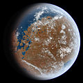
from tsunamis, as seen by HiRISE. The tsunamis were probably caused by asteroids striking the ocean. Boulders that were picked up, carried, and dropped...
45 KB (5,232 words) - 01:52, 10 June 2025

Center. National Oceanic and Atmospheric Administration. Archived from the original on 2008-07-04. "RPG SW BUILD 10.0 – INCLUDES REPORTING FOR SW 41 RDA"...
12 KB (1,459 words) - 04:29, 25 February 2025