
is also known as a geodetic network, reference network, control point network, or simply control network. A geodetic control network consists of stable...
7 KB (718 words) - 14:11, 14 May 2024


uncertainties. Merton Davies tied this crater into an extensive geodetic control network of the planet Mars based on Mariner 9 and earlier photographs....
6 KB (547 words) - 16:03, 21 May 2025

A geodetic datum or geodetic system (also: geodetic reference datum, geodetic reference system, or geodetic reference frame, or terrestrial reference...
32 KB (3,377 words) - 03:19, 15 May 2025

year in advance) and maps of India. Surveys: geodetic datum, geodetic control network, topographical control, geophysical surveys, cadastral surveying,...
14 KB (1,177 words) - 16:21, 1 April 2025

gravity anomalies (e.g. voids), and for establishing the vertical geodetic control network. Atom interferometric and atomic fountain methods are used for...
26 KB (3,187 words) - 21:16, 14 June 2025

The World Geodetic System (WGS) is a standard used in cartography, geodesy, and satellite navigation including GPS. The current version, WGS 84, defines...
24 KB (2,842 words) - 03:41, 26 April 2025

A. I.; "The Rotation Period, Direction of the North Pole, and Geodetic Control Network of Venus", Journal of Geophysical Research, vol. 97, no. 8, 1992...
61 KB (4,755 words) - 18:19, 15 June 2025

of national intelligence studies; the establishment of world geodetic control networks by both satellite and conventional triangulation methods; and...
16 KB (2,092 words) - 19:47, 6 June 2025

Geographic coordinate system (section Geodetic datum)
A geographic coordinate system (GCS) is a spherical or geodetic coordinate system for measuring and communicating positions directly on Earth as latitude...
23 KB (2,540 words) - 22:18, 14 May 2025
information system data products, color and photometric data products, a geodetic control network tied to radar altimetry, and a database of plume-search observations...
5 KB (504 words) - 09:46, 23 October 2024

Zakharov, "The Rotation Period, Direction of the North Pole, and Geodetic Control Network of Venus," Journal of Geophysical Research, Vol. 97, £8, pp. 13...
19 KB (2,166 words) - 18:42, 29 March 2025

establishing a system of horizontal measurement in the United States, known as geodetic datum. In 1913, the datum was adopted across all of North America, and...
15 KB (1,486 words) - 23:10, 30 March 2025

Cassini, of NEAR and Magellan. He was responsible for creating the geodetic control network for the mapping of the surface of Mars, and thus had the honor...
15 KB (1,997 words) - 14:02, 4 June 2025
The National Geodetic Survey (NGS) is a United States federal agency based in Washington, D.C. that defines and manages a national coordinate system, providing...
7 KB (762 words) - 13:07, 11 April 2025
gravitational field and how these properties change over time. geodetic control network geodetic datum A coordinate system and set of reference points used...
276 KB (28,404 words) - 21:41, 11 June 2025

Arc measurement (category Geodetic surveys)
al.). Struve measured a geodetic control network via triangulation between the Arctic Sea and the Black Sea, the Struve Geodetic Arc. This is a partial...
9 KB (957 words) - 15:22, 6 February 2025

Caryńska Church ruins View from Wołosaty View from Wyżna Pass Geodetic control network point 2nd class survey marker Bieszczady Mountains Brzegi Górne...
7 KB (398 words) - 20:59, 18 August 2024
operates as the National Geodetic Institute, adopting the reference ellipsoid, developing and maintaining the geodetic control network, defining the national...
14 KB (702 words) - 01:12, 13 March 2025

than a century later, Kokalj's survey team installed a precise geodetic control network around the falls and remeasured the drops with reflector-less electronic...
7 KB (824 words) - 10:09, 23 May 2025

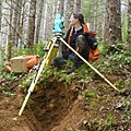
Triangulation station (redirect from Geodetic point)
sometimes informally as a trig, is a fixed surveying station, used in geodetic surveying and other surveying projects in its vicinity. The station is...
15 KB (1,740 words) - 05:20, 8 June 2025

1950", EPSG:4230) is a geodetic datum which was defined after World War II for the international connection of geodetic networks. Some of the important...
8 KB (923 words) - 15:13, 6 February 2025

Transcontinental Traverse (category United States Coast and Geodetic Survey)
Beltsville sites became part of a worldwide satellite geodesy network. Geodetic control network Great Trigonometrical Survey of India The High-precision Transcontinental...
8 KB (836 words) - 10:28, 27 May 2025

vertical control surveying in the United States based upon the General Adjustment of the North American Datum of 1988. It superseded the National Geodetic Vertical...
7 KB (730 words) - 01:21, 16 June 2025

among the earliest in the federal government: United States Coast and Geodetic Survey, formed in 1807 Weather Bureau of the United States, formed in 1870...
51 KB (4,995 words) - 02:30, 28 May 2025
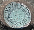
Survey marker (redirect from Geodetic mark)
survey monuments, or geodetic marks, are objects placed to mark key survey points on the Earth's surface. They are used in geodetic and land surveying....
10 KB (1,243 words) - 10:35, 27 May 2025
Surveying (section Plane vs. geodetic surveying)
standards. Standards control accuracy, surveying credentials, monumentation of boundaries and maintenance of geodetic networks. Many nations devolve...
57 KB (7,282 words) - 07:24, 12 March 2025

continually in their studies. The International Geodetic Association, which had covered Europe with a network of fundamental longitudes, took an interest...
17 KB (1,851 words) - 20:40, 2 May 2025
Global Positioning System (redirect from MObile System for Accurate ICBM Control)
Pacific Northwest Geodetic Array". cwu.edu. Archived from the original on September 11, 2014. Retrieved October 10, 2014. Arms Control Association.Missile...
184 KB (19,110 words) - 17:35, 15 June 2025

The squadron's initial role was to establish geodetic survey control, establish topographic survey control for mapping, compile and field complete preliminary...
42 KB (5,597 words) - 12:15, 8 June 2025