The Geographic Names Information System (GNIS) is a database of name and location information about more than two million physical and cultural features...
31 KB (3,688 words) - 04:11, 10 June 2025
China portal Geography portal Canada Geographic Information System China Historical Geographic Information System Geographic information system Geoinformatics...
9 KB (994 words) - 14:49, 2 May 2025
geographic location or geographic position). It is also called geospatial data and information,[citation needed] georeferenced data and information,[citation...
3 KB (259 words) - 13:26, 18 May 2025
locations in the Geographic Names Information System. The names of post offices have historically been used to back up claims about the name of a community...
16 KB (1,597 words) - 23:25, 18 February 2025
The BC Geographical Names (formerly BC Geographical Names Information System or BCGNIS) is a geographic name web service and database for the Canadian...
1 KB (106 words) - 08:17, 30 December 2024
pp. 97–100 Goodwin 2021, p. 285 "MacNaughton Mountain". Geographic Names Information System. United States Geological Survey, United States Department...
22 KB (2,069 words) - 11:32, 13 May 2025

List of mountain peaks of Montana (category Geographic coordinate lists)
Geodetic Survey. Retrieved June 14, 2016. "Granite Peak". Geographic Names Information System. United States Geological Survey, United States Department...
51 KB (4,717 words) - 10:01, 5 January 2025
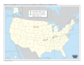
middle'". CNBC. 7 February 2021. U.S. Geological Survey Geographic Names Information System: Geographic Center of the Conterminous United States In the Middle...
11 KB (1,292 words) - 23:46, 1 June 2025
Puerto Rico List of swamps of Puerto Rico "Bano Grade Pool". Geographic Names Information System. United States Geological Survey, United States Department...
17 KB (1,098 words) - 06:42, 30 April 2025

Elk River Chain of Lakes Watershed (section Geography)
River". Geographic Names Information System. United States Geological Survey, United States Department of the Interior. "Elk River". Geographic Names Information...
14 KB (2,149 words) - 20:24, 21 February 2025

S. Geological Survey Geographic Names Information System: Jones Creek U.S. Geological Survey Geographic Names Information System: Deer Creek U.S. Geological...
7 KB (704 words) - 07:30, 3 February 2025

Geographic Names Information System: Mud Creek U.S. Geological Survey Geographic Names Information System: Mud Lake U.S. Geological Survey Geographic...
6 KB (752 words) - 05:25, 4 February 2025
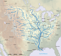
List of longest rivers of the United States (category Geographic coordinate lists)
coordinates are from the Geographic Names Information System (United States Geological Survey) or the Canadian Geographical Names Data Base except for the...
60 KB (3,200 words) - 06:43, 30 April 2025
List of mountain peaks of Colorado (category Geographic coordinate lists)
Geodetic Survey. Retrieved May 18, 2016. "Mount Elbert". Geographic Names Information System. United States Geological Survey, United States Department...
58 KB (6,673 words) - 18:33, 9 May 2025
Antarctic Place-names Committee. British Antarctic Survey - NERC. Retrieved 5 December 2020. "Barrett Buttress". Geographic Names Information System. United States...
25 KB (3,658 words) - 18:50, 4 February 2025
Geographic Names Information System. United States Geological Survey, United States Department of the Interior. Foscue, Virginia (1989). Place Names in...
141 KB (3,642 words) - 16:50, 26 June 2025
List of lakes of West Virginia (category Geographic coordinate lists)
CITEREFDe_Hart1988 (help) Geographic Names Information System; United States Geological Survey. "Geographic Names Information System: Feature Detail Report...
111 KB (5,020 words) - 02:29, 8 July 2025

Interior. Retrieved September 22, 2011. "Bullhead Mountain". Geographic Names Information System. United States Geological Survey, United States Department...
6 KB (544 words) - 13:44, 3 May 2025
List of the highest major summits of Colorado (category Geographic coordinate lists)
Geodetic Survey. Retrieved May 18, 2016. "Mount Elbert". Geographic Names Information System. United States Geological Survey, United States Department...
40 KB (7,379 words) - 10:02, 5 January 2025

Cumming Township, Michigan (section Geography)
Geological Survey Geographic Names Information System: Cumming Township, Michigan U.S. Geological Survey Geographic Names Information System: Camp Lu Lay Lea...
9 KB (951 words) - 16:31, 22 April 2024

List of mountain peaks of California (category Geographic coordinate lists)
Geodetic Survey. Retrieved June 8, 2016. "Mount Whitney". Geographic Names Information System. United States Geological Survey, United States Department...
54 KB (5,512 words) - 19:16, 5 January 2025
List of mountain ranges in Idaho (category Geographic coordinate lists)
Mountains". Geographic Names Information System. United States Geological Survey, United States Department of the Interior. "Arco Hills". Geographic Names Information...
28 KB (1,969 words) - 22:35, 21 March 2025

Arkansas River (category Geography of Tulsa, Oklahoma)
River". Geographic Names Information System. United States Geological Survey. October 13, 1978. Retrieved March 19, 2025. "Lake Creek". Geographic Names Information...
48 KB (3,897 words) - 17:49, 16 June 2025

Rumble Goat Mountain Matanuska Formation "Chugach Mountains". Geographic Names Information System. United States Geological Survey, United States Department...
10 KB (1,008 words) - 18:41, 6 June 2025
Geographic Names Information System. United States Geological Survey. Retrieved 2021-08-29. "Austhjelmen Peak". Geographic Names Information System....
22 KB (2,632 words) - 16:14, 28 July 2023
Summit Post. Retrieved October 31, 2016. "Flattop Mountain". Geographic Names Information System. United States Geological Survey, United States Department...
23 KB (1,669 words) - 19:17, 5 January 2025
INCITS 38:2009. The codes are used in Geographic Names Information System, overseen by the U.S. Board on Geographic Names. The codes were assigned by NIST...
15 KB (717 words) - 17:51, 4 January 2025

Clay Township, Michigan (section Geography)
Geological Survey Geographic Names Information System: Clay Township, Michigan U.S. Geological Survey Geographic Names Information System: Bedore, Michigan...
20 KB (2,154 words) - 21:27, 7 July 2025

Bay of Isles (section Named features)
Bay of Isles in January–February, 1983. "Bay of Isles". Geographic Names Information System. United States Geological Survey, United States Department...
12 KB (1,583 words) - 22:43, 23 March 2025

List of mountain peaks of Washington (category Geographic coordinate lists)
Geographic Names Information System. United States Geological Survey, United States Department of the Interior. "Mount Adams (Pahto)". Geographical Names...
61 KB (4,671 words) - 01:17, 30 January 2025